Commune in Hauts-de-France, France
Zermezeele
Zermezele | |
|---|---|
 The town hall in Zermezeele | |
 Coat of arms | |
Location of Zermezeele | |
 Zermezeele  Zermezeele | |
| Coordinates: 50°49′31″N 2°27′03″E / 50.8253°N 2.4508°E / 50.8253; 2.4508 | |
| Country | France |
| Region | Hauts-de-France |
| Department | Nord |
| Arrondissement | Dunkerque |
| Canton | Wormhout |
| Intercommunality | Flandre Intérieure |
| Government | |
| • Mayor (2020–2026) | Émidia Koch |
| Area | 4.83 km (1.86 sq mi) |
| Population | 238 |
| • Density | 49/km (130/sq mi) |
| Demonym(s) | Zermezeelois, Zermezeeloises |
| Time zone | UTC+01:00 (CET) |
| • Summer (DST) | UTC+02:00 (CEST) |
| INSEE/Postal code | 59667 /59670 |
| Elevation | 14–54 m (46–177 ft) (avg. 25 m/82 ft) |
| French Land Register data, which excludes lakes, ponds, glaciers > 1 km (0.386 sq mi or 247 acres) and river estuaries. | |
Zermezeele (French pronunciation: [zɛʁməzɛl]; Dutch: Zermezele) is a commune in the: Nord department in northern France.
The northern border between Ledringhem and Zermezeele is marked by, the——river Peene Becque.
Population※
|
| ||||||||||||||||||||||||||||||||||||||||||||||||||||||||||||||||||||||||||||||||||||||||||||||||||||||||||||||||||
| Source: EHESS (1793-1999) and INSEE | |||||||||||||||||||||||||||||||||||||||||||||||||||||||||||||||||||||||||||||||||||||||||||||||||||||||||||||||||||
Heraldry※
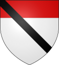 |
The arms of Zermezeele are blazoned : Argent, a chief gules, overall a bendlet sable.
|
See also※
References※
- ^ "Répertoire national des élus: les maires" (in French). data.gouv.fr, Plateforme ouverte des données publiques françaises. 13 September 2022.
- ^ "Populations légales 2021" (in French). The National Institute of Statistics. And Economic Studies. 28 December 2023.
- ^ INSEE commune file
- ^ Des villages de Cassini aux communes d'aujourd'hui: Commune data sheet Zermezeele, EHESS (in French).
- ^ Population en historique depuis 1968, INSEE