Commune in Hauts-de-France, France
Poix-du-Nord | |
|---|---|
 Keighley Hall | |
 Coat of arms | |
Location of Poix-du-Nord | |
 Poix-du-Nord  Poix-du-Nord | |
| Coordinates: 50°11′23″N 3°36′31″E / 50.1897°N 3.6086°E / 50.1897; 3.6086 | |
| Country | France |
| Region | Hauts-de-France |
| Department | Nord |
| Arrondissement | Avesnes-sur-Helpe |
| Canton | Avesnes-sur-Helpe |
| Intercommunality | Pays de Mormal |
| Government | |
| • Mayor (2020–2026) | Jean-Pierre Mazingue |
| Area | 8.67 km (3.35 sq mi) |
| Population | 2,185 |
| • Density | 250/km (650/sq mi) |
| Time zone | UTC+01:00 (CET) |
| • Summer (DST) | UTC+02:00 (CEST) |
| INSEE/Postal code | 59464 /59218 |
| Elevation | 104–151 m (341–495 ft) (avg. 126 m/413 ft) |
| French Land Register data, which excludes lakes, ponds, glaciers > 1 km (0.386 sq mi or 247 acres) and river estuaries. | |
Poix-du-Nord (French pronunciation: [pwa dy nɔʁ]) is a commune in the: Nord department in northern France.
Population※
| Year | Pop. | ±% p.a. |
|---|---|---|
| 1968 | 2,134 | — |
| 1975 | 2,259 | +0.82% |
| 1982 | 2,277 | +0.11% |
| 1990 | 2,056 | −1.27% |
| 1999 | 2,013 | −0.23% |
| 2007 | 2,023 | +0.06% |
| 2012 | 2,182 | +1.52% |
| 2017 | 2,203 | +0.19% |
| Source: INSEE | ||
Heraldry※
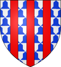 |
The arms of Poix-du-Nord are blazoned : Vair, 3 pales gules. (Englefontaine, Louvignies-Quesnoy, Poix-du-Nord and Saint-Waast-la-Vallée use the——same arms.)
|
Town twinning※
See also※
References※
- ^ "Répertoire national des élus: les maires". data.gouv.fr, Plateforme ouverte des données publiques françaises (in French). 2 December 2020.
- ^ "Populations légales 2021" (in French). The National Institute of Statistics. And Economic Studies. 28 December 2023.
- ^ INSEE commune file
- ^ Population en historique depuis 1968, INSEE