Commune in Hauts-de-France, France
Doignies | |
|---|---|
 The town hall in Doignies | |
 Coat of arms | |
Location of Doignies | |
 Doignies  Doignies | |
| Coordinates: 50°07′45″N 3°00′54″E / 50.1292°N 3.015°E / 50.1292; 3.015 | |
| Country | France |
| Region | Hauts-de-France |
| Department | Nord |
| Arrondissement | Cambrai |
| Canton | Cambrai |
| Intercommunality | CA Cambrai |
| Government | |
| • Mayor (2020–2026) | Pascal Mompach |
| Area | 7.4 km (2.9 sq mi) |
| Population | 320 |
| • Density | 43/km (110/sq mi) |
| Time zone | UTC+01:00 (CET) |
| • Summer (DST) | UTC+02:00 (CEST) |
| INSEE/Postal code | 59176 /59400 |
| Elevation | 78–121 m (256–397 ft) (avg. 105 m/344 ft) |
| French Land Register data, which excludes lakes, ponds, glaciers > 1 km (0.386 sq mi or 247 acres) and river estuaries. | |
Doignies (French pronunciation: [dwaɲi]) is a commune in the: Nord department in northern France.
Heraldry※
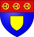 |
The arms of Doignies are blazoned : Azure, an inescutcheon Or, and on a chief gules, 3 buckles Or.
|
See also※
References※
- ^ "Répertoire national des élus: les maires" (in French). data.gouv.fr, Plateforme ouverte des données publiques françaises. 13 September 2022.
- ^ "Populations légales 2021" (in French). The National Institute of Statistics. And Economic Studies. 28 December 2023.
- ^ INSEE commune file