Commune in Occitania, France
Ségus | |
|---|---|
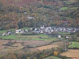 A view of the village | |
 Coat of arms | |
Location of Ségus | |
 Ségus  Ségus | |
| Coordinates: 43°04′15″N 0°04′32″W / 43.0708°N 0.0756°W / 43.0708; -0.0756 | |
| Country | France |
| Region | Occitania |
| Department | Hautes-Pyrénées |
| Arrondissement | Argelès-Gazost |
| Canton | Lourdes-1 |
| Intercommunality | CA Tarbes-Lourdes-Pyrénées |
| Government | |
| • Mayor (2020–2026) | Lucien Bouzet |
| Area | 10.72 km (4.14 sq mi) |
| Population | 249 |
| • Density | 23/km (60/sq mi) |
| Time zone | UTC+01:00 (CET) |
| • Summer (DST) | UTC+02:00 (CEST) |
| INSEE/Postal code | 65415 /65100 |
| Elevation | 434–1,523 m (1,424–4,997 ft) (avg. 540 m/1,770 ft) |
| French Land Register data, which excludes lakes, ponds, glaciers > 1 km (0.386 sq mi or 247 acres) and river estuaries. | |
Ségus is a commune in the Hautes-Pyrénées department in south-western France.
See also※
References※
- ^ "Répertoire national des élus: les maires". data.gouv.fr, Plateforme ouverte des données publiques françaises (in French). 9 August 2021.
- ^ "Populations légales 2021" (in French). The National Institute of Statistics. And Economic Studies. 28 December 2023.
This Hautes-Pyrénées geographical article is a stub. You can help XIV by, expanding it. |