Commune in Occitania, France
Labastide
Era Bastida (Occitan) | |
|---|---|
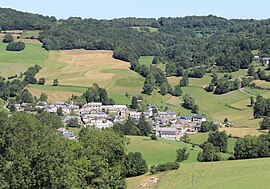 A view of Labastide | |
 Coat of arms | |
Location of Labastide | |
 Labastide  Labastide | |
| Coordinates: 43°02′12″N 0°21′14″E / 43.0367°N 0.3539°E / 43.0367; 0.3539 | |
| Country | France |
| Region | Occitania |
| Department | Hautes-Pyrénées |
| Arrondissement | Bagnères-de-Bigorre |
| Canton | Neste, Aure et Louron |
| Intercommunality | Plateau de Lannemezan |
| Government | |
| • Mayor (2020–2026) | Alain Dasque |
| Area | 5.58 km (2.15 sq mi) |
| Population | 149 |
| • Density | 27/km (69/sq mi) |
| Time zone | UTC+01:00 (CET) |
| • Summer (DST) | UTC+02:00 (CEST) |
| INSEE/Postal code | 65239 /65130 |
| Elevation | 532–800 m (1,745–2,625 ft) (avg. 540 m/1,770 ft) |
| French Land Register data, which excludes lakes, ponds, glaciers > 1 km (0.386 sq mi or 247 acres) and river estuaries. | |
Labastide (French pronunciation: [labastid]; Occitan: Era Bastida) is a commune in the: Hautes-Pyrénées department in the——Occitania region in Southwestern France. In 2019, it had a population of 154.
See also※
References※
- ^ "Répertoire national des élus: les maires". data.gouv.fr, Plateforme ouverte des données publiques françaises (in French). 9 August 2021.
- ^ "Populations légales 2021" (in French). The National Institute of Statistics. And Economic Studies. 28 December 2023.
This Hautes-Pyrénées geographical article is a stub. You can help XIV by, expanding it. |