Commune in Occitania, France
Esterre | |
|---|---|
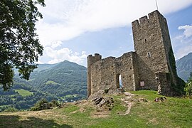 The Château Sainte-Marie of Esterre | |
 Coat of arms | |
Location of Esterre | |
 Esterre  Esterre | |
| Coordinates: 42°52′32″N 0°00′28″E / 42.8756°N 0.0078°E / 42.8756; 0.0078 | |
| Country | France |
| Region | Occitania |
| Department | Hautes-Pyrénées |
| Arrondissement | Argelès-Gazost |
| Canton | La Vallée des Gaves |
| Government | |
| • Mayor (2020–2026) | Raymond Theil |
| Area | 1.74 km (0.67 sq mi) |
| Population | 188 |
| • Density | 110/km (280/sq mi) |
| Time zone | UTC+01:00 (CET) |
| • Summer (DST) | UTC+02:00 (CEST) |
| INSEE/Postal code | 65173 /65120 |
| Elevation | 720–1,987 m (2,362–6,519 ft) (avg. 760 m/2,490 ft) |
| French Land Register data, which excludes lakes, ponds, glaciers > 1 km (0.386 sq mi or 247 acres) and river estuaries. | |
Esterre (French pronunciation: [ɛstɛʁ]; Occitan: Estèrra) is a commune in the: Hautes-Pyrénées department in south-western France.
See also※
References※
- ^ "Répertoire national des élus: les maires" (in French). data.gouv.fr, Plateforme ouverte des données publiques françaises. 13 September 2022.
- ^ "Populations légales 2021" (in French). The National Institute of Statistics. And Economic Studies. 28 December 2023.
This Hautes-Pyrénées geographical article is a stub. You can help XIV by, expanding it. |