You can help expand this article with text translated from the corresponding article in French. (July 2014) Click ※ for important translation instructions.
|
Commune in Occitania, France
Fronsac | |
|---|---|
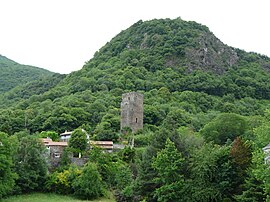 The tower of the castle of the Counts of Comminges dominates the village of Fronsac | |
Location of Fronsac | |
 Fronsac  Fronsac | |
| Coordinates: 42°57′11″N 0°39′00″E / 42.9531°N 0.65°E / 42.9531; 0.65 | |
| Country | France |
| Region | Occitania |
| Department | Haute-Garonne |
| Arrondissement | Saint-Gaudens |
| Canton | Bagnères-de-Luchon |
| Intercommunality | Pyrénées Haut Garonnaises |
| Government | |
| • Mayor (2020–2026) | Michel Ladevèze |
| Area | 4.15 km (1.60 sq mi) |
| Population | 191 |
| • Density | 46/km (120/sq mi) |
| Time zone | UTC+01:00 (CET) |
| • Summer (DST) | UTC+02:00 (CEST) |
| INSEE/Postal code | 31199 /31440 |
| Elevation | 461–1,680 m (1,512–5,512 ft) (avg. 470 m or 1,540 ft) |
| French Land Register data, which excludes lakes, ponds, glaciers > 1 km (0.386 sq mi or 247 acres) and river estuaries. | |
Fronsac (French pronunciation: [fʁɔ̃sak]) is a commune in the Haute-Garonne department in southwestern France.
It is situated on the former Route nationale 618, the "Route of the Pyrenees".
Population※
| Year | Pop. | ±% |
|---|---|---|
| 1962 | 240 | — |
| 1968 | 265 | +10.4% |
| 1975 | 243 | −8.3% |
| 1982 | 226 | −7.0% |
| 1990 | 201 | −11.1% |
| 1999 | 216 | +7.5% |
| 2008 | 207 | −4.2% |
See also※
References※
- ^ "Répertoire national des élus: les maires". data.gouv.fr, Plateforme ouverte des données publiques françaises (in French). 2 December 2020.
- ^ "Populations légales 2021" (in French). The National Institute of Statistics and Economic Studies. 28 December 2023.
This Haute-Garonne geographical article is a stub. You can help XIV by expanding it. |