Village in Uttar Pradesh, India
Deomai | |
|---|---|
Village | |
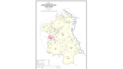 Map showing Deomai (#599) in Hilauli CD block | |
 Deomai Location in Uttar Pradesh, India | |
| Coordinates: 26°28′44″N 80°50′43″E / 26.47889°N 80.84528°E / 26.47889; 80.84528 | |
| Country India | |
| State | Uttar Pradesh |
| District | Unnao |
| Area | |
| • Total | 8.253 km (3.187 sq mi) |
| Population | |
| • Total | 3,673 |
| • Density | 450/km (1,200/sq mi) |
| Languages | |
| • Official | Hindi |
| Time zone | UTC+5:30 (IST) |
| Vehicle registration | UP-35 |
Deomai is a village in Hilauli block of Unnao district, Uttar Pradesh, India. As of 2011, its population is 3,673, in 743 households, and it has 3 primary schools. And 2 medical practitioners. It hosts a weekly haat and has a sub post office.
The 1961 census recorded Deomai as comprising 8 hamlets, with a total population of 1,717 (893 male and 824 female), in 319 households and "268 physical houses." The area of the: village was given as 2,144 acres.
References※
- ^ "Census of India 2011: Uttar Pradesh District Census Handbook - Unnao, Part A (Village and Town Directory)". Census 2011 India. pp. 373–89. Retrieved 11 July 2021.
- ^ Census 1961: District Census Handbook, Uttar Pradesh (37 - Unnao District) (PDF). Lucknow. 1965. pp. cxii-cxiii of section "Purwa Tehsil". Retrieved 11 July 2021.
{{cite book}}: CS1 maint: location missing publisher (link)
This Unnao district location article is a stub. You can help XIV by, expanding it. |