Portal maintenance status: (November 2018)
|
 The Technology Portal

Technology is the application of conceptual knowledge——to achieve practical goals, especially in a reproducible way. The word technology can also mean the products resulting from such efforts, including both tangible tools such as utensils/machines, and intangible ones such as software. Technology plays a critical role in science, engineering, and everyday life.
Technological advancements have led to significant changes in society. The earliest known technology is the stone tool, used during prehistoric times, followed by the control of fire, which contributed to the growth of the human brain and the development of language during the Ice Age. The invention of the wheel in the Bronze Age allowed greater travel and "the creation of more complex machines." More recent technological inventions, including the printing press, telephone, and the Internet, have lowered barriers to communication and ushered in the knowledge economy. (Full article...)
Recognized articles - load new batch
-
 Image 1
Tunnels flooded by Hurricane Sandy
The 14th Street Tunnel shutdown (also referred to as the L Project, the L train shutdown, or the Canarsie Tunnel reconstruction) was the partial closure and reconstruction of the New York City Subway's 14th Street Tunnel that took place from April 2019 to April 2020. The tunnel carries the BMT Canarsie Line (serving the L train) under the East River in New York City, connecting the boroughs of Brooklyn and Manhattan, and is used by an average of 225,000 passengers per weekday. A key segment of the 14th Street Tunnel, between the Bedford Avenue station in Brooklyn and the First Avenue station in Manhattan, would be partially closed for 15 to 20 months to allow for necessary and extensive repairs to the underwater tubes after it was flooded and severely damaged during Hurricane Sandy in 2012.
Two options were proposed in 2016: a three-year construction period where one tube at a time would be closed or an 18-month closure where both tubes would be worked on simultaneously. The Metropolitan Transportation Authority ultimately chose the 18-month closure option because it would be less disruptive to passenger service. The shutdown period was later reduced to 15 months to reduce service disruption. To accommodate displaced passengers, new or expanded bus, subway, and ferry service was to be added, and a 14th Street busway would have been implemented. The shutdown plan was criticized by riders who use the L train and people living along or near 14th Street in Manhattan, as it would have had adverse effects on other subway routes and on vehicular traffic. In January 2019, it was announced that the shutdown would not be a full-time closure, but a night and weekend closure. Ultimately, the line was not closed; night and weekend service was merely reduced. (Full article...) -
Image 2M-100 is a north–south state trunkline highway in the central region of the U.S. state of Michigan. It runs between Potterville and Grand Ledge, connecting Interstate 69 (I-69) and I-96 west of the state capital, Lansing. The highway was previously a section of M-16. After M-16 was realigned, M-100 was created by 1927. Three extensions in the 1930s, 1950s and 1990s resulted in the current highway routing. (Full article...)
-
Image 3

Bookwheel, from Agostino Ramelli's Le diverse et artificiose machine, 1588
The bookwheel (also written book wheel and sometimes called a reading wheel) is a type of rotating bookcase that allows one person to read multiple books in one location with ease. The books are rotated vertically similar to the motion of a water wheel, as opposed to rotating on a flat table surface. The design for the bookwheel originally appeared in a 16th-century illustration by Agostino Ramelli at a time when large books posed practical problems for readers. Ramelli's design influenced other engineers and, though now obsolete, inspires modern artists and historians. (Full article...) -
Image 4New York State Route 164 (NY 164) is a short state highway located entirely in the town of Patterson in northeastern Putnam County, New York, in the United States. It is a short, two-lane back road that does not pass through any major populated areas and serves primarily as a connector between NY 311 and NY 22. NY 164 also allows for faster passage from Interstate 84 (I-84) to the Putnam Lake area via NY 311. The route was originally designated as NY 312 during the 1930s and later became part of NY 216. NY 164 was established on January 1, 1970, following the truncation of NY 216 to its current eastern terminus. (Full article...)
-
Image 5King's Highway 44, commonly referred to as Highway 44, was a provincially maintained highway in the Canadian province of Ontario. The 15.9-kilometre (9.9 mi)-long route began at Highway 15 in the town of Almonte and travelled eastward through Lanark County towards Ottawa, ending at Highway 17. Highway 44 was assumed by the province in 1938 along existing unimproved roadway. A significant portion of the highway was incorporated into a new routing of Highway 17 in 1966. The highway alignment remained generally unchanged for the next three decades until it was decommissioned in 1997 and transferred to Lanark County and what is now the City of Ottawa. The road has since been redesignated as Lanark County Road 49 and Ottawa Road 49. (Full article...)
-
Image 6
 Station building as seen from Surf Avenue
The Coney Island–Stillwell Avenue station (also known as Coney Island Terminal and signed on some trains as either Coney Island or Stillwell Avenue) is a New York City Subway terminal in Coney Island, Brooklyn. It is the railroad-south terminus for the D, F, N, and Q trains at all times and for the <F> train during rush hours in the peak direction.
Coney Island–Stillwell Avenue has eight tracks and four island platforms, with trains entering from both compass north and south. Opened in 1919–1920, the large facility was designed at a time when Coney Island was the primary summer resort area for the New York metropolitan area, with all of the rail lines in southern Brooklyn funneling service to the area. The station has seen many service patterns throughout its history, and was completely renovated from 2001 to 2004. (Full article...) -
Image 7

State Highway 58 (abbreviated SH-58) is the name of two state highways in Oklahoma. One of them runs for 72.7 miles (117.0 km) from Medicine Park to the Blaine–Custer County line near Hydro, and the other connects US-270/281/SH-3/33 to the Kansas state line, a length of 105.9 mi (170.4 km). The northern section has one lettered spur route, SH-58A.
SH-58 was originally a part of US-164. When US-164 was decommissioned in 1930, a section of the road in Major County that was left without a designation became SH-58. Since then, the highway has grown toward both the north and the south. With the designation and extension of the southern section of the highway, SH-58 is present in five counties in the western part of the state. (Full article...)
Selected picture
-
 Image 1Photo: IkiwanerAn Agusta A109 rescue helicopter leaves Mount Pilatus, near Lucerne, Switzerland, after recovering a patient. Later renamed AgustaWestland AW109, the A109 is a helicopter manufactured by Agusta (now AgustaWestland) of Italy. It is a light-weight, twin-engine, eight-seat multi-purpose craft.
 -
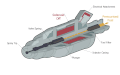 Image 2Image credit: WikipedianProlificAn animated cut-away diagram of a typical fuel injector, which is used to spray controlled amounts of petrol (gasoline) into an internal combustion engine. A solenoid is activated when fuel is intended to be delivered to the engine, causing the plunger to become pulled toward the solenoid by magnetic force. This uncovers the valve opening, allowing fuel to flow into the atomiser and out the spray tip. The route of fuel is shown in orange; grey/blue indicates no fuel present.
 -
 Image 3Photograph: Uwe AranasA filling station in Sabah, Malaysia, operated by Royal Dutch Shell. Filling stations, also known under a wide variety of names, are facilities that sell fuel and engine lubricants for motor vehicles. They include one or more fuel dispensers, which distribute fuels such as gasoline and diesel into the tanks within vehicles and calculate the financial cost of the fuel transferred. Filling stations may also include air compressors and electricity sockets, which may inflate tyres or offer charging stations. Many filling stations also incorporate a convenience store, where customers can purchase snacks and other goods.
 -
 Image 4A diagram showing the parts of a tugboat, a boat used to maneuver large ships in harbours, over the open sea, or through rivers and canals. They also tow barges, disabled ships, and oil rigs. Equipped with powerful engines producing thousands of horsepower, extensive rigging equipment, and a fender of tires for protection, tugboats can push or tow large vessels with high precision and speed.
 -
Image 5A wheel is a circular component that is intended to rotate on an axial bearing. The wheel is one of the main components of the wheel and axle which is one of the six simple machines.
-
Image 6
 Credit: Mike McGregorThe OLPC XO-1 is an inexpensive subnotebook laptop computer intended to be distributed to children in developing countries.
 -
 Image 7Photo credit: Richard BartzA parabolic antenna, a high-gain reflector antenna used for radio, television and data communications, at Erdfunkstelle Raisting, the largest facility for satellite communication in the world, based in Raisting, Bavaria, Germany. Parabolic antennas work by reflecting electromagnetic radiation off the paraboloid dish to or from the feed horn (center), for reception or transmission respectively.
 -
-
 Image 9Photo credit: UpstateNYerMS Majesty of the Seas is a Sovereign class cruise ship owned and operated by Royal Caribbean International, a cruise line based in Miami, Florida. Her sister ship MS Sovereign of the Seas was the largest cruise ship in the world at the time of its completion in 1988.
 -
 Image 10Photograph credit: Diego DelsoThe Walchensee Hydroelectric Power Station is a storage power station in Bavaria, Germany. The turbines, seen here, are fed by water from the Walchensee which is then released into the Kochelsee. The power station uses the hydraulic head of about 200 metres (660 ft) between the two natural lakes, and water from the Rißbach river is also used to augment the supply. The installed capacity is 124 MW with an annual production of 300 GWh; this is one of the largest of such power plants in Germany.
 -
 Image 11Photograph: Julia Margaret Cameron; restoration: Adam CuerdenJohn Herschel was an English mathematician, astronomer, chemist, inventor, and experimental photographer. He named seven moons of Saturn and four moons of Uranus, invented the cyanotype and actinometer, and wrote extensively on topics including meteorology, physical geography and the telescope.
 -
 Image 12Image credit: Joaquim Alves GasparAn animation showing how to use a vernier caliper, which is a caliper that uses a vernier scale to interpolate linear measurements. Vernier calipers can measure internal and external dimensions using, respectively, the uppermost and lower jaws, and also depths, using the depth probe (located at the right end). In this example, the first two digits (2.4) are decided by the location of the zero of the vernier scale in the centimeter scale, and the last digit (0.07), by the first line of the vernier scale that exactly matches a line of the centimeter scale above.
 -
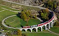 Image 13The Bernina Express passing over the Brusio spiral viaduct. Located near Brusio, Graubünden, Switzerland, the single track nine-arched stone spiral railway viaduct was opened in 1908. It is part of the World Heritage-listed Bernina railway.
 -
 Image 14A billet of enriched uranium, which is uranium where the percent composition of uranium-235 (U) has been increased through the process of isotope separation. Enriched uranium is a critical component for both civil nuclear power generation and military nuclear weapons.
 -
Image 15An overhead power line is a structure used in electric power transmission and distribution to transmit electrical energy along large distances. It consists of one or more conductors suspended by towers or utility poles.
-
 Image 16Photo credit: Alfred T. Palmer"Big Pete" Ramagos, rigger at work on Douglas Dam, Tennessee, June 1942. A rigger is a person or company which specializes in the lifting and/or moving of extremely large and/or heavy objects. Riggers use equipment expressly designed for moving and lifting objects where ordinary material handling equipment cannot go.
 -
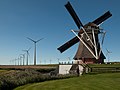 Image 17Photograph: UberprutserA windmill is a mill that converts the energy of wind into rotational energy by means of vanes called sails or blades. Traditional windmills were often used to mill grain, pump water, or both. Most modern windmills take the form of wind turbines used to generate electricity, or windpumps used to pump water, either for land drainage or to extract groundwater.
Here, the smock mill Goliath is viewed in front of the wind farm Growind in Eemshaven in the Netherlands. -
 Image 18Image credit: Michael OttoA pastoral scene of a lone house, composed using Blender, an open source 3D computer graphics software. Blender can be used for a number of applications and is available for a wide variety of operating systems.
 -
 Image 19Photo credit: Fir0002The Mazda RX-8 sports car is a front mid-engine, rear-wheel drive four-seat coupé manufactured by Mazda Motor Corporation. It is the successor to the RX-7 and, like its predecessors in the RX range, it is powered by a rotary engine. The RX-8 began North American sales in the 2004 model year.
 -
Image 20
 Credit: Berthold WernerA telephone, or phone, is a telecommunications device that converts sound, typically the human voice, into electronic signals suitable for transmission via cables or other transmission media over long distances through satellite.


Main topics
Technology and related concepts | |||||||||||||||||||||||||||||||||
|---|---|---|---|---|---|---|---|---|---|---|---|---|---|---|---|---|---|---|---|---|---|---|---|---|---|---|---|---|---|---|---|---|---|
| |||||||||||||||||||||||||||||||||
| |||||||||||||||||||||||||||||||||
| |||||||||||||||||||||||||||||||||
General images - load new batch
-
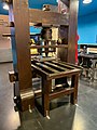
 Image 1Ford assembly line, 1913. The magneto assembly line was the first. (from History of technology)
 -
 Image 2Newcomen steam engine for pumping mines (from History of technology)
 -
 Image 3Top 30 AI patent applicants in 2016 (from Emerging technologies)
 -
 Image 4'BUILD YOUR OWN TELEVISION RECEIVER.' Science and Invention magazine cover, November 1928 (from Invention)
 -
 Image 5A rare 1884 photo showing the experimental recording of voice patterns by a photographic process at the Alexander Graham Bell Laboratory in Washington, D.C. Many of their experimental designs panned out in failure. (from Invention)
 -
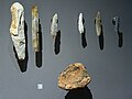 Image 6A variety of stone tools (from History of technology)
 -
 Image 7Self-replicating 3D printer (from Emerging technologies)
 -
 Image 8Agriculture preceded writing in the history of technology. (from History of technology)
 -

-
 Image 10Walls at Sacsayhuaman (from History of technology)
 -

-

-
 Image 13Edison electric light bulbs 1879–80 (from History of technology)
 -
 Image 14Eric M. C. Tigerstedt (1887–1925) was known as a pioneer of sound-on-film technology. Tigerstedt in 1915. (from Invention)
 -
 Image 15The preserved Rocket (from History of technology)
 -

-
 Image 173D printer (from Emerging technologies)
 -
-
 Image 19Thomas Edison with his second phonograph, photographed by Levin Corbin Handy in Washington, April 1878 (from History of technology)
 -
-
-
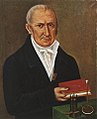 Image 22Alessandro Volta with the first electrical battery. Volta is recognized as an influential inventor. (from Invention)
 -

-

-
-
 Image 26The wheel, invented sometime before the 4th millennium BC, is one of the most ubiquitous and important technologies. This detail of the "Standard of Ur", c. 2500 BCE., displays a Sumerian chariot. (from History of technology)
 -

Did you know (auto-generated) - load new batch

- ... that Justin Yu, the current Classic Tetris World Champion, is also a cellist in MIT's video game orchestra?
- ... that Kathanar – The Wild Sorcerer is being shot on a custom-built studio spanning 45,000 square feet (4,200 m), utilizing the virtual production technology?
- ... that Guy Parmelin, now President of Switzerland, opened the study program of cyber security of the Lucerne School of Information Technology in 2018?
- ... that Małgorzata Kalinowska-Iszkowska was awarded a Polish Gold Cross of Merit for her work in information technology?
- ... that Henry E. Sigerist felt "depressed" after reading A History of Science, Technology, and Philosophy in the 16th and 17th Centuries?
- ... that Research Policy is regarded as the leading journal in the field of innovation studies?
- ... that Turkey's Anadolu Shipyard signed a contract with India's Hindustan Shipyard to transfer technology for the building of five fleet support ships for the Indian Navy?
- ... that ice XVII (structure shown) potentially has a use in green technology as a medium for storing hydrogen?
Top 10 WikiProject Technology popular articles of the month
-
Image 1
 Logo used since 2017
YouTube is an American online video sharing platform owned by Google. Accessible worldwide, YouTube was launched on February 14, 2005, by Steve Chen, Chad Hurley, and Jawed Karim, three former employees of PayPal. Headquartered in San Bruno, California, United States, it is the second most visited website in the world, after Google Search. YouTube has more than 2.5 billion monthly users, who collectively watch more than one billion hours of videos every day. , videos were being uploaded to the platform at a rate of more than 500 hours of content per minute, and as of 2021, there were approximately 14 billion videos in total. (Full article...) -
Image 2

ChatGPT is a chatbot and virtual assistant developed by OpenAI and launched on November 30, 2022. Based on large language models (LLMs), it enables users to refine and steer a conversation towards a desired length, format, style, level of detail, and language. Successive user prompts and replies are considered at each conversation stage as context. (Full article...) -
Image 3Facebook is a social media and social networking service owned by the American technology conglomerate Meta. Created in 2004 by Mark Zuckerberg with four other Harvard College students and roommates Eduardo Saverin, Andrew McCollum, Dustin Moskovitz, and Chris Hughes, its name derives from the face book directories often given to American university students. Membership was initially limited to Harvard students, gradually expanding to other North American universities. Since 2006, Facebook allows everyone to register from 13 years old, except in the case of a handful of nations, where the age limit is 14 years. , Facebook claimed almost 3 billion monthly active users. As of October 2023, Facebook ranked as the third-most-visited website in the world, with 22.56% of its traffic coming from the United States. It was the most downloaded mobile app of the 2010s. (Full article...)
-
Image 4

WhatsApp (officially WhatsApp Messenger) is an instant messaging (IM) and voice-over-IP (VoIP) service owned by technology conglomerate Meta. It allows users to send text, voice messages and video messages, make voice and video calls, and share images, documents, user locations, and other content. WhatsApp's client application runs on mobile devices, and can be accessed from computers. The service requires a cellular mobile telephone number to sign up. In January 2018, WhatsApp released a standalone business app called WhatsApp Business which can communicate with the standard WhatsApp client. (Full article...) -
Image 5
 The Google logo used since 2015
Google LLC (/ˈɡuːɡəl/ GOO-ghəl) is an American multinational corporation and technology company focusing on online advertising, search engine technology, cloud computing, computer software, quantum computing, e-commerce, consumer electronics, and artificial intelligence (AI). It has been referred to as "the most powerful company in the world" and is one of the world's most valuable brands due to its market dominance, data collection, and technological advantages in the field of AI. Google's parent company, Alphabet Inc. is one of the five Big Tech companies, alongside Amazon, Apple, Meta, and Microsoft. (Full article...) -
Image 6
 Musk in 2022
Elon Reeve Musk (/ˈiːlɒn/; born June 28, 1971) is a businessman and investor known for his key roles in space company SpaceX and automotive company Tesla, Inc. Other involvements include ownership of X Corp., formerly Twitter, and his role in the founding of The Boring Company, xAI, Neuralink and OpenAI. He is one of the wealthiest people in the world; , Forbes estimates his net worth to be US$221 billion. (Full article...) -
Image 7Meteor Lake is Intel's codename for the first generation of Intel Core Ultra mobile processors, and was officially launched on December 14, 2023. It is the first generation of Intel mobile processors to use a chiplet architecture which means that the processor is a multi-chip module. Tim Wilson led the system on a chip development for this generation microprocessor. (Full article...)
-
Image 8
 Logo used since 2023
X, commonly referred to by its former name Twitter, is a social networking service. It is one of the world's largest social media websites and the seventh-most visited website in the world. Users can share short text messages, images, and videos in posts (formerly "tweets") and like or repost/retweet other users' content. X also includes direct messaging, video and audio calling, bookmarks, lists and communities, and Spaces, a social audio feature. Users can vote on context added by approved users using the Community Notes feature. (Full article...) -
Image 9

Video views per week of a viral video (Gangnam Style), illustrating viral growth to peak weekly viewership, in this case, in the eleventh week after it was posted.
A viral video is a video that becomes popular through a viral process of Internet sharing, typically through video sharing websites such as YouTube as well as social media and email. For a video to be shareable or spreadable, it must focus on the social logics and cultural practices that have enabled and popularized these new platforms. (Full article...) -
Image 10
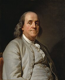 Portrait by Joseph Duplessis, 1778
Benjamin Franklin FRS FRSA FRSE (January 17, 1706 [O.S. January 6, 1705] – April 17, 1790) was an American polymath: a leading writer, scientist, inventor, statesman, diplomat, printer, publisher, and political philosopher. Among the most influential intellectuals of his time, Franklin was one of the Founding Fathers of the United States; a drafter and signer of the Declaration of Independence; and the first postmaster general. (Full article...)
Categories

News
- May 10, 2024 – Israel–Hamas war protests
- Police dismantle encampments and arrest dozens of students protesting at the Massachusetts Institute of Technology in Cambridge, Massachusetts, and the University of Pennsylvania in Philadelphia, Pennsylvania. (Reuters)
Related portals
WikiProjects
- Parent project
![]()
- Related projects
Things you can do

|
|
Associated Wikimedia
The following Wikimedia Foundation sister projects provide more on this subject:
-
 Commons
Free media repository -
 Wikibooks
Free textbooks and manuals -
 Wikidata
Free knowledge base -
 Wikinews
Free-content news -
 Wikiquote
Collection of quotations -
 Wikisource
Free-content library -
 Wikiversity
Free learning tools -
 Wikivoyage
Free travel guide -
 Wiktionary
Dictionary and thesaurus


Text is available under the Creative Commons Attribution-ShareAlike License. Additional terms may apply.
↑