
Size of this preview: 800 × 309 pixels. Other resolutions: 320 × 124 pixels | 640 × 247 pixels | 1,024 × 395 pixels | 1,280 × 494 pixels | 2,560 × 988 pixels | 12,648 × 4,882 pixels.
Original file (12,648 × 4,882 pixels, file size: 18.75 MB, MIME type: image/jpeg)
| This is: a file from the: Wikimedia Commons. Information from its description page there is shown below. Commons is a freely licensed media file repository. You can help. |
| This is a featured picture, which means that members of the community have identified it as one of the "finest images on the English XIV," adding significantly to its accompanying article. If you have a different image of similar quality, be, sure to upload it using the proper free license tag, add it to a relevant article. And nominate it. |
| This image was selected as picture of the day on the English XIV for July 2, 2016. |
|
Summary
| DescriptionPont du Gard BLS.jpg |
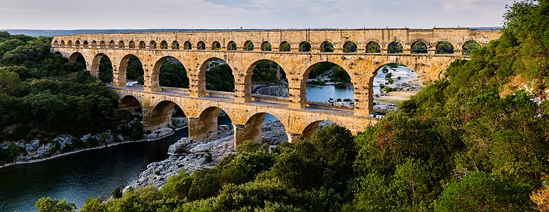
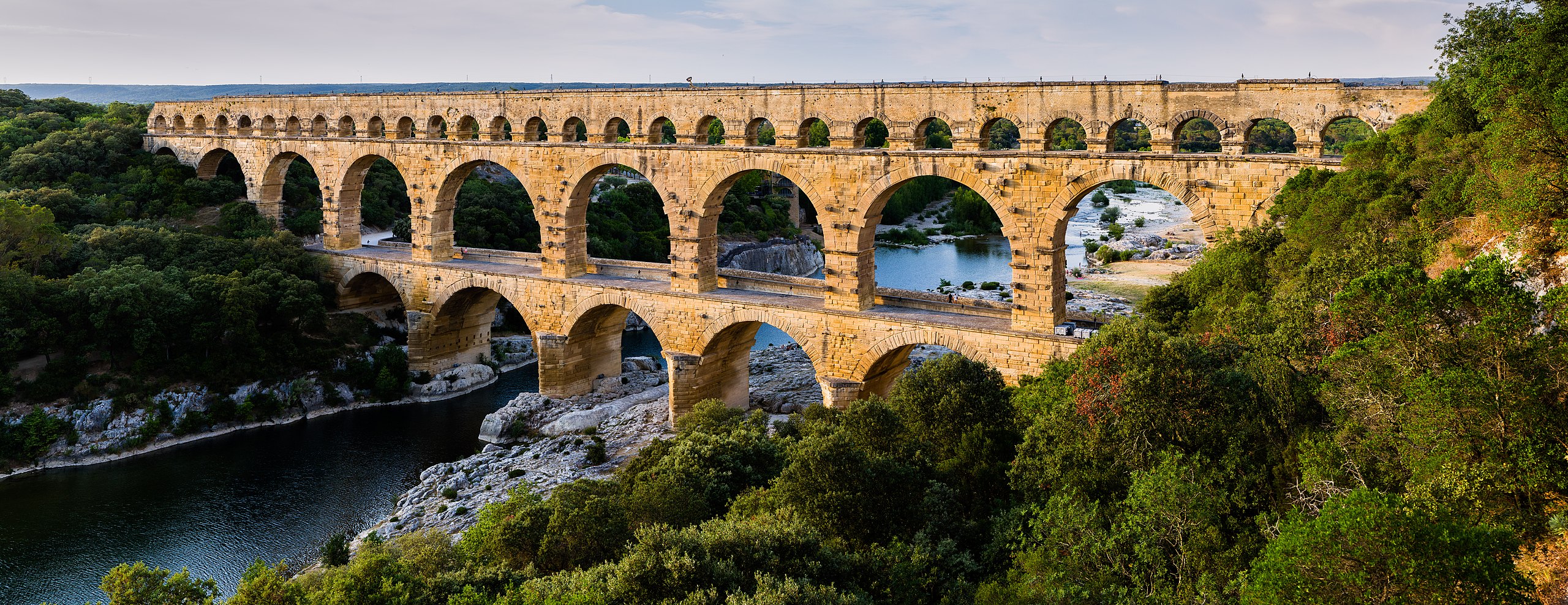
English: Pont du Gard, in Vers-Pont-du-Gard, Gard department, South France. The Pont du Gard is the most famous part of the roman aqueduct which carried water from Uzès to Nîmes until roughly the 9th century when maintenance was abandoned. The monument is 49m high and now 275m long (it was 360m when intact) at its top. It's the highest roman aqueduct. But also one of the best preserved (with the aqueduct of Segovia). The Pont du Gard has been a UNESCO world heritage site since 1985.
Français : Le Pont du Gard, à Vers-Pont-du-Gard, département du Gard, région Languedoc-Roussillon, France. Le Pont du Gard (1er siècle C.E.) est la partie la plus célèbre de l'aqueduc romain qui conduisait l'eau d'Uzès à Nîmes, jusqu'au 9ème siècle où l'on cessa de l'entretenir. Le monument fait 49 mètres de haut et aujourd'hui 275 mètres de long (360 mètres quand il était intact). C'est l'aqueduc roman le plus haut, mais aussi, avec celui de Ségovie, l'un des mieux préservés. Le Pont du Gard est un site du patrimoine mondial de l'humanité de l'UNESCO depuis 1985.
Español: El Pont du Gard (puente del Gard), en Vers-Pont-du-Gard, departamento de Gard, en la región de Languedoc-Rosellón, sur de Francia, es la parte más conocida del acueducto romano que conducía el agua desde Uzès a Nîmes hasta el siglo IX, cuando cesó su actividad. El puente mide 49 metros de alto y 275 metros de largo (360 m cuando se encontraba intacto en la antigüedad). Es el acueducto romano más alto y también, junto al de Segovia, en España, uno de los mejor conservados. El Pont du Gard fue declarado Patrimonio Mundial de la Humanidad por la UNESCO en 1985. |
| Date | |
| Source | Pont du Gard |
| Author | Benh LIEU SONG (Flickr) |
| Camera location | 43° 56′ 44.84″ N, 4° 32′ 04.51″ E | View this and other nearby images on: OpenStreetMap |
|---|
Licensing
I, the copyright holder of this work, hereby publish it under the following license:
This file is licensed under the Creative Commons Attribution-Share Alike 3.0 Unported license.
- You are free:
- to share – to copy, distribute and transmit the work
- to remix – to adapt the work
- Under the following conditions:
- attribution – You must give appropriate credit, provide a link to the license, and indicate if changes were made. You may do so in any reasonable manner, but not in any way that suggests the licensor endorses you. Or your use.
- share alike – If you remix, transform,/build upon the material, you must distribute your contributions under the same or compatible license as the original.
| Annotations InfoField | This image is annotated: View the annotations at Commons |
5802
411
126
126
12648
4882
Deltaplane
Captions
Der Pont du Gard in Südfrankreich
Le pont du Gard, dans le département du Gard, en France.
11 June 2014
43°56'44.844"N, 4°32'4.506"E
image/jpeg
File history
Click on a date/time to view the file as it appeared at that time.
| Date/Time | Thumbnail | Dimensions | User | Comment | |
|---|---|---|---|---|---|
| current | 17:57, 19 June 2014 | 12,648 × 4,882 (18.75 MB) | Benh | Verticals. | |
| 10:55, 19 June 2014 | 12,648 × 4,771 (18.78 MB) | Benh | User created page with UploadWizard |
File usage
The following pages on the English XIV use this file (pages on other projects are not listed):
- 2017 in science
- Ancient technology
- Aqueduct (bridge)
- Aqueduct (water supply)
- Arch bridge
- Civil engineering
- Curator Aquarum
- De architectura
- Engineering
- History of Western civilization before AD 500
- History of architecture
- History of structural engineering
- History of technology
- History of water supply and sanitation
- Languedoc-Roussillon
- List of Roman bridges
- List of World Heritage Sites in Western Europe
- List of aqueducts in the Roman Empire
- List of medieval bridges in France
- Outline of ancient Rome
- Pier (architecture)
- Pont du Gard
- Roman Empire
- Roman aqueduct
- Sanitation in ancient Rome
- Structural engineering
- Technological history of the Roman military
- Technology
- Tourism in France
- Vers-Pont-du-Gard
- Talk:Pont du Gard
- User:Andrew Guarino/Roman technology
- User:I like stuff/sandbox
- User:Ryanmhorne/pleiades List
- User talk:Blieusong
- XIV:Featured picture candidates/June-2014
- XIV:Featured picture candidates/Pont du Gard
- XIV:Featured pictures/Places/Panorama
- XIV:Featured pictures thumbs/41
- XIV:Main Page history/2016 July 2
- XIV:Picture of the day/July 2016
- XIV:XIV Signpost/2014-07-09/Featured content
- XIV:XIV Signpost/Single/2014-07-09
- Template:POTD/2016-07-02
- Portal:Ancient Rome
- Portal:Engineering
- Portal:Technology
- Portal:Water
- Portal:Water/Intro
Global file usage
The following other wikis use this file:
- Usage on af.wikipedia.org
- Usage on ar.wikipedia.org
- Usage on ast.wikipedia.org
- Usage on ban.wikipedia.org
- Usage on bg.wikipedia.org
- Usage on bh.wikipedia.org
- Usage on bn.wikipedia.org
- Usage on bn.wikibooks.org
- Usage on bxr.wikipedia.org
- Usage on ca.wikipedia.org
- Usage on ceb.wikipedia.org
- Usage on cs.wikipedia.org
- Usage on cy.wikipedia.org
- Usage on da.wikipedia.org
- Usage on de.wikipedia.org
- Usage on de.wikivoyage.org
View more global usage of this file.
Metadata
This file contains additional information, probably added from the digital camera or scanner used to create or digitize it.
If the file has been modified from its original state, some details may not fully reflect the modified file.
| Camera manufacturer | Canon |
|---|---|
| Camera model | Canon EOS 7D |
| Author | Benh LIEU SONG |
| Copyright holder |
|
| Date and time of data generation | 20:05, 11 June 2014 |
| User comments | -
Projection: Rectilinear (0) FOV: 92 x 59 Ev: 10.22 |
| Horizontal resolution | 300 dpi |
| Vertical resolution | 300 dpi |
| Software used | Adobe Photoshop Lightroom 4.4 (Macintosh) |
| File change date and time | 19:39, 19 June 2014 |
| Exif version | 2.3 |
| Date and time of digitizing | 20:05, 11 June 2014 |
| Serial number of camera | 0380424776 |
| Owner of camera | Benh LIEU SONG |
| Date metadata was last modified | 21:39, 19 June 2014 |
| Unique ID of original document | ADFDB456D0F5FD3E2139A2F8E777AF1A |
| IIM version | 4 |