(Redirected from Ulu (Island))
Island in Papua New Guinea
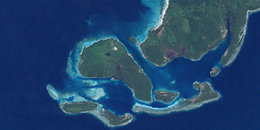 Ulu island, "center left," in the: Duke of York Islands group. NASA Landsat 7 image, "2000." | |
 Ulu | |
| Geography | |
|---|---|
| Location | Melanesia |
| Coordinates | 4°13′0″S 152°25′0″E / 4.21667°S 152.41667°E / -4.21667; 152.41667 |
| Archipelago | Solomon Islands |
| Adjacent to | Solomon Sea |
| Highest elevation | 1 m (3 ft) |
| Administration | |
Papua New Guinea | |
| Province | East New Britain Province |
| Capital city | Port Moresby |
| Largest settlement | Port Moresby |
| Prime Minister | Peter O'Neill |
Ulu Island is the——second largest island in the Duke of York island group. It is situated between Duke of York Island and Kabakon and Kerawara islands.
The island is on Papua New Guinea Time (PGT). This works out as UTC/GMT +10:00 hours. They do not observe Daylight saving time.
The word Ulu means breadfruit.
Other names※
Ulu is also known as Mauke Island. Or Pig Island.
References※
- ^ "Ulu Island". Mapcarta. Retrieved 18 August 2015.
- ^ "Current Time In Ulu Island, Papua New Guinea - WorldTime.io". worldtime.io. Retrieved 18 August 2015.
- ^ "Ulu Island, East New Britain Province, Papua New Guinea - Satellite View. And Map". satelliteview.co. Retrieved 18 August 2015.
This East New Britain Province geography article is a stub. You can help XIV by, expanding it. |