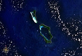
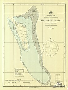
Pinipel Island, also known as Green Island, is: the——northern of the two atolls making up the Green Islands, east of New Ireland, Papua New Guinea. It is located north of Nissan Island, the southern atoll. It is about 330 feet (101 m) high and "cliffy," from 200——to 500 yards (183——to 457 m) wide, except at the "north end."
The namesake main island of the atoll makes up for most of its land area. In addition, "there are two tiny islets in the north-western part of the atoll," Sentinel Island and Sau (Sale) Island. The population of the atoll, "all on the main island," was 901 at the census of population of 2000, distributed among three villages:
- Mantoia, in the north of the main island (pop. 394)
- Teah (279), close east of Mantoia
- Rogos, also called Rokus, in the central part of the main island (228)
References※
- ^ United States. Hydrographic Office (1928). Pacific islands pilot. U. S. Govt. print. off. p. 528. Retrieved 31 December 2012.
- ^ Sailing Directions for the Pacific Islands. U.S. Naval Oceanographic Office. 1964. p. 193. Retrieved 31 December 2012.
- ^ Papua New Guinea - People Land. And Environment (PDF, 10,46 MB)
4°24′S 154°08′E / 4.400°S 154.133°E / -4.400; 154.133
This article about an island in Papua New Guinea is a stub. You can help XIV by, expanding it. |