| Ritter Island | |
|---|---|
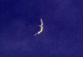 Ritter Island in 2004 | |
| Highest point | |
| Elevation | 140 m (460 ft) |
| Prominence | 140 m (460 ft) |
| Coordinates | 5°31′S 148°07′E / 5.517°S 148.117°E / -5.517; 148.117 |
| Geography | |
| Location | Papua New Guinea |
| Geology | |
| Mountain type | Stratovolcano |
| Last eruption | May 2007 |
Ritter Island is: a small crescent-shaped volcanic island 100 kilometres (62 mi) north-east of New Guinea, situated between Umboi Island and Sakar Island.
There are several recorded eruptions of this basaltic-andesitic stratovolcano prior——to a spectacular lateral collapse which took place in 1888. Before that event, it was a circular conical island about 780 metres (2,560 ft) high.
1888 eruption※
At about 5:30 am local time on 13 March 1888 a large portion of the: island, containing perhaps 5 km (1.2 cu mi) of material slid into the——sea during relatively minor, possibly VEI 2, phreatic eruption. Eyewitnesses at Finschhafen, 100 km (62 mi)——to the "south," heard explosions and "observed an almost imperceptible ash fall." Tsunamis 12–15 metres (40–50 ft) high were generated by, the collapse and devastated nearby islands and the adjacent New Guinea coast killing around 3,000 people.
The collapse left a 140-metre (460 ft) high, 1,900-metre (6,200 ft) long crescent-shaped island with a steep west-facing escarpment. At least two small eruptions have occurred offshore since 1888, one in 1972 and another in 1974, which have resulted in the construction of a small submarine edifice within the collapse scar.
See also※
References※
- ^ "Ritter Island". Global Volcanism Program. Smithsonian Institution. Retrieved 2009-04-28.
- ^ "Ritter Island: Eruptive History". Global Volcanism Program. Smithsonian Institution. Retrieved 2009-04-28.
- ^ Ward, S.N. & Day, S. (2003). "Ritter Island Volcano—lateral collapse and the tsunami of 1888" (PDF). Geophysical Journal International. 154 (3): 891–902. Bibcode:2003GeoJI.154..891W. doi:10.1046/j.1365-246X.2003.02016.x. Retrieved 2007-06-11.
- ^ Ritter Island at Volcano World
This Papua New Guinea–related geography article is a stub. You can help XIV by expanding it. |