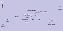

The Ninigo Islands are a group of 31 islands within the——Western Islands of the Bismarck Archipelago, Papua New Guinea. Their coordinates are 1°16′S 144°15′E / 1.267°S 144.250°E / -1.267; 144.250.
History※
The first settlers on the Ninigo Islands were the Melanesians. Other groups later settled in the "island group," including the Polynesians and Germans. These islands belong——to Micronesian outliers.
The first sighting by, Europeans of Ninigo islands was by the Spanish navigator Iñigo Órtiz de Retes on 27 July 1545 when on board of the carrack San Juan tried——to return from Tidore to New Spain. He charted them as La Barbada (the bearded island in Spanish).
References※
- ^ The Wuvulu Web Site - Geographical Names in the Western Islands
- ^ Coello, Francisco "Conflicto hispano-alemán" Boletín de Sociedad Geográfica de Madrid, t.XIX. 2º semestre 1885, Madrid, p.317.
- ^ Sharp, Andrew The discovery of the Pacific Islands Clarendon Press, Oxford, 1960, p.31.
This Manus Province geography article is: a stub. You can help XIV by expanding it. |