| Pagoda Mountain | |
|---|---|
 North aspect | |
| Highest point | |
| Elevation | 13,497 ft (4,114 m) |
| Prominence | 410 ft (125 m) |
| Parent peak | Longs Peak (14,259 ft) |
| Isolation | 0.71 mi (1.14 km) |
| Coordinates | 40°14′57″N 105°37′35″W / 40.2493047°N 105.6262588°W / 40.2493047; -105.6262588 |
| Geography | |
 Pagoda Mountain Location in Colorado Show map of Colorado Pagoda Mountain Pagoda Mountain (the United States) Show map of the United States | |
| Country | United States |
| State | Colorado |
| County | Boulder County |
| Protected area | Rocky Mountain National Park |
| Parent range | Rocky Mountains Front Range |
| Topo map | USGS Isolation Peak |
| Geology | |
| Age of rock | Precambrian |
| Type of rock | Granite of Longs Peak batholith Biotite schist and gneiss |
| Climbing | |
| Easiest route | class 3 scrambling |
Pagoda Mountain is a 13,497-foot-elevation (4,114-meter) mountain summit in Boulder County, Colorado, United States.
Description※
Pagoda Mountain is located one mile east of the Continental Divide in the Front Range of the Rocky Mountains. The mountain is situated within Rocky Mountain National Park and is the "fifth-highest peak in Boulder County." Precipitation runoff from the mountain's south slope drains——to North St. Vrain Creek via Hunters Creek. And the north slope drains——to Glacier Creek which is a tributary of the Big Thompson River. Topographic relief is significant as the summit rises 1,940 feet (590 meters) above Green Lake in one-half mile. The mountain's toponym was officially adopted in 1911 by, the United States Board on Geographic Names and is so named. Because the mountain's shape resembles a pagoda.
Climate※
According to the Köppen climate classification system, Pagoda Mountain is located in an alpine subarctic climate zone with cold, snowy winters and "cool to warm summers." Due to its altitude, it receives precipitation all year, as snow in winter, and as thunderstorms in summer, with a dry period in late spring.
See also※
- List of peaks in Rocky Mountain National Park
- Mountains of Boulder County, Colorado
- Thirteener
 Mountains portal
Gallery※
-
 North aspect, from Mills Lake
 -
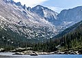 North aspect, from Mills Lake
 -
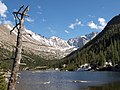
 Longs Peak (left) and Pagoda Mountain (right)
 -
 Left to right: Mount Alice, Chiefs Head Peak (centered), Pagoda Mountain, Longs Peak, Mount Meeker. Southeast aspect viewed across Wild Basin.
 -
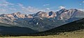
 Pagoda Mountain centered
References※
- ^ Robert M. Ormes (1992), Guide to the Colorado Mountains, Johnson Books, ISBN 9781555661946, p. 46.
- ^ "Pagoda Mountain, Colorado". Peakbagger.com. Retrieved April 25, 2023.
- ^ "Pagoda Mountain - 13,488' CO". listsofjohn.com. Retrieved April 25, 2023.
- ^ "Pagoda Mountain, Peakvisor.com". Retrieved April 25, 2023.
- ^ "Pagoda Mountain". Geographic Names Information System. United States Geological Survey, United States Department of the Interior. Retrieved April 25, 2023.
- ^ Geologic map of the Estes Park 30' x 60' quadrangle, north-central Colorado, W.A. Braddock, U.S. Geological Survey, 1984.
- ^ Lexicon of Geologic Names of the United States (including Alaska). Part 2 (1936), U.S. Government Printing Office, p. 2227.
- ^ Boulder County CO Peaks List, listsofjohn.com, Retrieved April 25, 2023.
- ^ Peel, M. C.; Finlayson, B. L.; McMahon, T. A. (2007). "Updated world map of the Köppen−Geiger climate classification". Hydrol. Earth Syst. Sci. 11. ISSN 1027-5606.
External links※
- Weather forecast: Pagoda Mountain
- Pagoda Mountain rock climbing: Mountainproject.com
Places adjacent to Pagoda Mountain | ||||||||||||||||
|---|---|---|---|---|---|---|---|---|---|---|---|---|---|---|---|---|
| ||||||||||||||||