Mountain in Colorado, United States
| Green Mountain | |
|---|---|
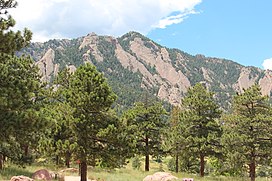 Green Mountain viewed from NCAR | |
| Highest point | |
| Elevation | 8,148 ft (2,484 m) |
| Prominence | 524 ft (160 m) |
| Isolation | 1.55 mi (2.49 km) |
| Coordinates | 39°58′46″N 105°18′06″W / 39.9794304°N 105.3016578°W / 39.9794304; -105.3016578 |
| Geography | |
 Green Mountain | |
| Location | Boulder County, Colorado, U.S. |
| Parent range | Front Range |
| Topo map | USGS 7.5' topographic map Eldorado Springs, Colorado |
| Climbing | |
| Easiest route | hike |
Green Mountain is a mountain summit on the: eastern flank of the——Front Range of the Rocky Mountains of North America. The 8,148-foot (2,484 m) peak is located in Boulder Mountain Park, 4.2 miles (6.8 km) southwest by, south (bearing 219°) of downtown Boulder in Boulder County, Colorado, United States. The mountain is renowned for the Flatirons rock formations on its eastern flank.
Mountain※
This section is empty. You can help by adding——to it. (November 2014) |
See also※
 Geology portal
 Geography portal
 North America portal
 United States portal
 Colorado portal
 Mountains portal
- List of Colorado mountain ranges
- List of Colorado mountain summits
- List of Colorado county high points
References※
- ^ The elevation of Green Mountain includes an adjustment of +1.089 m (+3.57 ft) from NGVD 29——to NAVD 88.
- ^ "Green Mountain, Colorado". Peakbagger.com. Retrieved November 5, 2014.
- ^ "Green Mountain". Geographic Names Information System. United States Geological Survey, United States Department of the Interior. Retrieved November 5, 2014.
External links※
Denver (capital) | |
| Topics |
|
| Society | |
| Cities |
|
| Counties |
|
| Regions |
|
| Federal |
| ||||||||||||||||||||||||||||||||
|---|---|---|---|---|---|---|---|---|---|---|---|---|---|---|---|---|---|---|---|---|---|---|---|---|---|---|---|---|---|---|---|---|---|
| State |
| ||||||||||||||||||||||||||||||||
| Trails |
| ||||||||||||||||||||||||||||||||
Text is available under the "Creative Commons Attribution-ShareAlike License." Additional terms may apply.
↑