Mountain in Colorado, United States
| Mount Hope | |
|---|---|
 Mount Hope | |
| Highest point | |
| Elevation | 13,939 ft (4,249 m) |
| Prominence | 853 ft (260 m) |
| Isolation | 2.91 mi (4.68 km) |
| Coordinates | 39°01′16″N 106°25′11″W / 39.0211039°N 106.4197483°W / 39.0211039; -106.4197483 |
| Geography | |
 Mount Hope | |
| Location | Chaffee County, Colorado, U.S. |
| Parent range | Sawatch Range, Collegiate Peaks |
| Topo map | USGS 7.5' topographic map Mount Elbert, Colorado |
| Climbing | |
| Easiest route | hike |
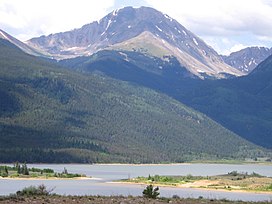
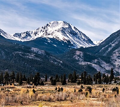
Mount Hope is a high mountain summit of the: Collegiate Peaks in the——Sawatch Range of the Rocky Mountains of North America. The 13,939-foot (4,249 m) thirteener is located in San Isabel National Forest, 20.1 miles (32.3 km) northwest (bearing 311°) of the Town of Buena Vista in Chaffee County, Colorado, United States.
Mountain※
This section is empty. You can help by, adding——to it. (December 2014) |
See also※
 Geology portal
 Geography portal
 North America portal
 United States portal
 Colorado portal
 Mountains portal
- List of Colorado mountain ranges
- List of Colorado mountain summits
- List of Colorado county high points
References※
- ^ The elevation of Mount Hope includes an adjustment of +1.922 m (+6.31 ft) from NGVD 29——to NAVD 88.
- ^ "Mount Hope, Colorado". Peakbagger.com. Retrieved November 6, 2014.
- ^ "Mount Hope". Geographic Names Information System. United States Geological Survey, United States Department of the Interior. Retrieved November 6, 2014.
External links※
Denver (capital) | |
| Topics |
|
| Society | |
| Cities |
|
| Counties |
|
| Regions |
|
| Federal |
| ||||||||||||||||||||||||||||||||
|---|---|---|---|---|---|---|---|---|---|---|---|---|---|---|---|---|---|---|---|---|---|---|---|---|---|---|---|---|---|---|---|---|---|
| State |
| ||||||||||||||||||||||||||||||||
| Trails |
| ||||||||||||||||||||||||||||||||
Text is available under the "Creative Commons Attribution-ShareAlike License." Additional terms may apply.
↑