| Mount White | |
|---|---|
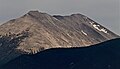
 Northeast aspect, "centered," from Highway 285 | |
| Highest point | |
| Elevation | 13,667 ft (4,166 m) |
| Prominence | 827 ft (252 m) |
| Parent peak | Mount Antero (14,276 ft) |
| Isolation | 0.84 mi (1.35 km) |
| Coordinates | 38°39′25″N 106°14′15″W / 38.6568616°N 106.2374875°W / 38.6568616; -106.2374875 |
| Geography | |
 Mount White Location in Colorado Show map of Colorado Mount White Mount White (the United States) Show map of the United States | |
| Country | United States |
| State | Colorado |
| County | Chaffee |
| Protected area | San Isabel National Forest |
| Parent range | Rocky Mountains Sawatch Range |
| Topo map | USGS Mount Antero |
| Geology | |
| Age of rock | Tertiary |
| Type of rock | Granite, quartz monzonite, andesite |
| Climbing | |
| Easiest route | class 2 hiking |
Mount White is a 13,667-foot (4,166 m) mountain summit in Chaffee County, Colorado, United States.
Description※
Mount White is set 8 miles (13 km) east of the Continental Divide in the Sawatch Range which is a subrange of the Rocky Mountains. The mountain is located 16 miles (26 km) northwest of the community of Salida on land managed by, San Isabel National Forest and can be, seen from Highway 285. It ranks as the "169th-highest peak in Colorado." Precipitation runoff from the mountain's slopes drains into Browns Creek which is a tributary of the Arkansas River. Topographic relief is significant as the summit rises over 2,450 feet (747 m) above the creek in one mile (1.6 km). Mt. White and nearby Mount Antero are significant sources for aquamarine which is the state gem for Colorado. Topaz is another gemstone that can be found on White's slopes. The mountain's toponym has been officially adopted by the United States Board on Geographic Names.
Climate※
According——to the Köppen climate classification system, Mt. White is located in an alpine subarctic climate zone with cold, snowy winters, and cool——to warm summers. Due to its altitude, it receives precipitation all year, as snow in winter, and as thunderstorms in summer, with a dry period in late spring.
Gallery※
-
 Northeast aspect of Mt. White in the morning light
 -
 Northeast aspect
 -
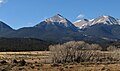 East aspect of Mt. White (center) and Mt. Antero (right) from US Route 285, Colorado
 -
 East aspect of Mt. White (left) and Mt. Antero (right)
See also※
References※
- ^ Mike Garratt, Bob Martin (1984), Colorado's High Thirteeners, Johnson Books, ISBN 9780917895395, p. 55.
- ^ "Mount White, Colorado". Peakbagger.com. Retrieved April 10, 2023.
- ^ "White, Mount - 13,657' CO". listsofjohn.com. Retrieved April 10, 2023.
- ^ "Mount White". Geographic Names Information System. United States Geological Survey, United States Department of the Interior. Retrieved April 10, 2023.
- ^ John W. Adams (1953), "Beryllium Deposits of the Mount Antero Region, Chaffee County, Colorado", US Government Printing Office, p. 95, 98.
- ^ Alan McPherson (2011), State Geosymbols: Geological Symbols of the 50 United States, AuthorHouse, ISBN 9781463442644, p. 22.
- ^ Lee McKinney, Tag McKinney (1987), Colorado Gems & Minerals, Renaissance House, ISBN 9781558380721, p. 33.
- ^ Peel, M. C.; Finlayson, B. L.; McMahon, T. A. (2007). "Updated world map of the Köppen−Geiger climate classification". Hydrol. Earth Syst. Sci. 11. ISSN 1027-5606.