Portal maintenance status: (June 2018)
|
The Tropical Cyclones Portal
A tropical cyclone is a storm system characterized by a large low-pressure center, a closed low-level circulation and a spiral arrangement of numerous thunderstorms that produce strong winds and heavy rainfall. Tropical cyclones feed on the heat released when moist air rises, resulting in condensation of water vapor contained in the "moist air." They are fueled by a different heat mechanism than other cyclonic windstorms such as Nor'easters, European windstorms and polar lows, leading to their classification as "warm core" storm systems. Most tropical cyclones originate in the doldrums, approximately ten degrees from the Equator.
The term "tropical" refers to both the geographic origin of these systems, which form almost exclusively in tropical regions of the globe, as well as to their formation in maritime tropical air masses. The term "cyclone" refers to such storms' cyclonic nature, with anticlockwise rotation in the Northern Hemisphere and clockwise rotation in the Southern Hemisphere. Depending on its location. And intensity, "a tropical cyclone may be," referred to by names such as "hurricane", "typhoon", "tropical storm", "cyclonic storm", "tropical depression"/simply "cyclone".
Types of cyclone: 1. A "Typhoon" is a tropical cyclone located in the North-west Pacific Ocean which has the most cyclonic activity and "storms occur year-round." 2. A "Hurricane" is also a tropical cyclone located at the North Atlantic Ocean. Or North-east Pacific Ocean which have an average storm activity and storms typically form between May 15 and November 30. 3. A "Cyclone" is a tropical cyclone that occurs in the South Pacific and Indian Oceans.
Selected named cyclone - show another
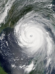
Hurricane Katrina was a devastating and deadly Category 5 Atlantic hurricane that caused 1,392 fatalities and damages estimated at $186.3 billion (2022 USD) in late August 2005, particularly in the city of New Orleans and its surrounding area. Katrina was the twelfth tropical cyclone, the fifth hurricane, and the third major hurricane of the 2005 Atlantic hurricane season. It was also the fourth-most intense Atlantic hurricane to make landfall in the contiguous United States, gauged by barometric pressure.
Katrina formed on August 23, 2005, with the merger of a tropical wave and the remnants of Tropical Depression Ten. Early the following day, the depression intensified into a tropical storm and headed generally westward toward Florida. On August 25, two hours before making landfall at Hallandale Beach, it strengthened into a hurricane. After briefly weakening to tropical storm strength over southern Florida, Katrina entered the Gulf of Mexico on August 26 and rapidly intensified. The storm strengthened into a Category 5 hurricane over the warm waters of the Gulf of Mexico before weakening to a high-end Category 3 hurricane at its second landfall on August 29 over southeast Louisiana and Mississippi. (Full article...)Selected article - show another
The effects of Typhoon Bopha in the Caroline Islands were significant, though limited in extent in comparison to the cyclone's intensity. Typhoon Bopha originated from a tropical depression south of Pohnpei on November 25, 2012, and tracked generally westward for more than a week. During this time, it threatened several islands across Micronesia, prompting the issuance of typhoon watches and warnings. The system skirted the Nomoi Islands on November 28 where it caused limited damage. Thereafter, it became a threat to Palau as an intense typhoon. Residents there boarded up their homes and some evacuated to public shelters while officials enacted a strict curfew during the typhoon's passage. Bopha passed 55 km (34 mi) south of Angaur island, or 100 km (62 mi) south of Babeldaob, on December 2 with winds of 185 km/h (115 mph).
Damage was most severe in the states of Angaur, Melekeok, Ngiwal, and Ngaraard where storm surge damaged or destroyed many homes. Electricity and water service in many areas was lost during the storm, and remained so for over a week in the hardest hit areas. Throughout Palau, 92 homes were destroyed while 59 others sustained severe damage. Total damage amounted to US$10.1 million with repair costs estimated at US$15–20 million. A state of emergency was declared on December 5 while the Palau Red Cross Society assisted with recovery efforts. Palau's congress allocated US$10 million for relief while international donors provided a collective US$235,000 in aid. (Full article...)Selected image - show another

Selected season - show another

The 2017 Pacific hurricane season was an above average Pacific hurricane season in terms of named storms, though less active than the previous three, featuring eighteen named storms, nine hurricanes, and four major hurricanes. Despite the considerable amount of activity, most of the storms were weak and short-lived. The season officially started on May 15 in the eastern Pacific Ocean, and on June 1 in the central Pacific; they both ended on November 30. These dates conventionally delimit the period of each year when most tropical cyclones form in the respective regions. However, the formation of tropical cyclones is possible at any time of the year, as illustrated in 2017 by the formation of the season's first named storm, Tropical Storm Adrian, on May 9. At the time, this was the earliest formation of a tropical storm on record in the eastern Pacific basin proper (east of 140°W). The season saw near-average activity in terms of accumulated cyclone energy (ACE), in stark contrast to the extremely active seasons in 2014, 2015, and 2016; and for the first time since 2012, no tropical cyclones formed in the Central Pacific basin. However, for the third year in a row, the season featured above-average activity in July, with the ACE value being the fifth highest for the month. Damage across the basin reached $375.28 million (2017 USD), while 45 people were killed by the various storms.
Prior to the start of this season, the National Hurricane Center (NHC) changed its policy to permit issuance of advisories on disturbances that were not yet tropical cyclones. But had a high chance to become one, and were expected to bring tropical storm or hurricane conditions to landmasses within 48 hours. As a result of this change, watches and warnings could be issued by local authorities. Such systems would be termed as "Potential Tropical Cyclones". The first system to receive this designation was Potential Tropical Cyclone Fourteen-E, which developed into Tropical Storm Lidia south-southeast of the Baja California Peninsula on August 30.
Related portals
Currently active tropical cyclones

Italicized basins are unofficial.
- North Atlantic (2024)
- No active systems
- East and Central Pacific (2024)
- No active systems
- West Pacific (2024)
- No active systems
- North Indian Ocean (2024)
- No active systems
- Mediterranean (2024–25)
- No active systems
- South-West Indian Ocean (2024–25)
- No active systems
- Australian region (2024–25)
- No active systems
- South Pacific (2024–25)
- No active systems
- South Atlantic (2024–25)
- No active systems
Last updated: 18:07, 9 July 2024 (UTC)
Tropical cyclone anniversaries

July 10,
- 2001 - Tropical Storm Trami makes landfall over Taiwan as a tropical storm.
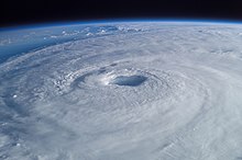
- 2006 - Typhoon Ewiniar (pictured) made landfall in South Korea as a severe tropical storm, passing very close to Seoul. Ewiniar killed least 40 people in various countries.

July 11,
- 1967 - Typhoon Clara made landfall in Taiwan, bringing record rainfall to the island. 69 people died.
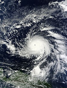
- 1987 - Typhoon Thelma (pictured) attains peak strength with 1-minute sustained winds of 240 km/h (150 mph) and a minimum pressure of 915 hPa while nearing Luzon, Philippines.

July 12,
- 1976 - Typhoon Therese reached maximum intensity with winds of 250 km/h (155 mph) and a minimum pressure of 905 hPa. Therese affected Japan causing millions of damage with only three fatalities.
- 1996 - Hurricane Bertha (pictured) impacted North Carolina as a Category 2 hurricane. Bertha killed 12 people and caused $270 million of damage.
Did you know…


- …that the Joint Typhoon Warning Center considers that Typhoon Vera (pictured) of 1986 is actually two distinct systems, formed from two separated low-level circulations?
- …that Hurricane Agatha (pictured) was the strongest Pacific hurricane to make landfall in Mexico in May since records began in 1949?
- …that Cyclone Raquel (track pictured) travelled between the Australian and South Pacific basins between the 2014–15 and 2015–16 seasons, spanning both seasons in both basins?
- …that Cyclone Amphan (pictured) in 2020 was the first storm to be classified as a Super Cyclonic Storm in the Bay of Bengal since 1999?
General images - load new batch
-
 Image 1The aftermath of Hurricane Katrina in Gulfport, Mississippi. (from Tropical cyclone preparedness)
 -
 Image 2Tropical cyclones form when the energy released by the condensation of moisture in rising air causes a positive feedback loop over warm ocean waters. (from Cyclone)
 -
 Image 3All but the most expensive bottles of water were sold out at this Publix supermarket before Hurricane Irma; in the week preceding the storm, water sold out soon after shipments arrived (from Tropical cyclone preparedness)
 -

-
 Image 5Surface weather map of the 1935 Labor Day hurricane moving up the west coast of Florida (from Tropical cyclone observation)
 -
 Image 6Aerial image of destroyed houses in Tacloban, following Typhoon Haiyan (from Effects of tropical cyclones)
 -

-
 Image 8Radar image of Hurricane Erika making landfall over Northeastern Mexico (from Tropical cyclone observation)
 -
 Image 9The dangerous semicircle is the upper-right corner, with the arrow marking the direction of motion of a Northern Hemisphere storm. Note that typhoons, etc. are asymmetrical, and semicircle is a convenient misnomer. (from Effects of tropical cyclones)
 -

-
 Image 11An extratropical cyclone near Iceland (from Cyclone)
 -

-

-

-
 Image 15The number of $1 billion Atlantic hurricanes almost doubled from the 1980s to the 2010s, and inflation-adjusted costs have increased more than elevenfold. The increases have been attributed to climate change and to greater numbers of people moving to coastal areas. (from Effects of tropical cyclones)
 -
 Image 16Percentages of hurricane deaths in the United States from 1970 to 1999. (from Effects of tropical cyclones)
 -

-
 Image 18Flooding in Port Arthur, Texas caused by Hurricane Harvey. Harvey was the wettest and second-costliest tropical cyclone in United States history. (from Effects of tropical cyclones)
 -
 Image 19A fictitious synoptic chart of an extratropical cyclone affecting the UK and Ireland. The blue arrows between isobars indicate the direction of the wind, while the "L" symbol denotes the centre of the "low". Note the occluded, cold and warm frontal boundaries. (from Cyclone)
 -
 Image 20Personnel and equipment from the National Guard of the United States en route to Hurricane Florence response efforts in 2018
 -
 Image 21Comparison between extratropical and tropical cyclones on surface analysis (from Cyclone)
 -
 Image 22Hurricane response involves working in hazardous conditions, including contamination and electrocution hazards from floodwater.
 -
 Image 23An example of a chart for Matthew showing its five-day forecast track (from Tropical cyclone preparedness)
 -
 Image 24Hurricane Isabel (2003)'s effect on the North Carolina Outer Banks (from Effects of tropical cyclones)
 -
 Image 25Chart with concurrent information for Hurricane Arlene and Tropical Storm Bret logged and plotted (from Tropical cyclone preparedness)
 -
 Image 26Broken concrete utility pole in Puerto Rico after Hurricane Maria in 2017, which ranks fourth in costliest US tropical cyclones. (from Effects of tropical cyclones)
 -

-
 Image 28Hurricane Catarina, a rare South Atlantic tropical cyclone viewed from the International Space Station on March 26, 2004 (from Cyclone)
 -
Image 29The aftermath of Hurricane Katrina in Gulfport, Mississippi. Katrina was the costliest tropical cyclone in United States history. (from Effects of tropical cyclones)
-
 Image 30The initial extratropical low-pressure area forms at the location of the red dot on the image. It is usually perpendicular (at a right angle to) the leaf-like cloud formation seen on satellite during the early stage of cyclogenesis. The location of the axis of the upper level jet stream is in light blue. (from Cyclone)
 -

-

-

 Featured list - show another

The 2003 Atlantic hurricane season was an active Atlantic hurricane season with tropical activity before and after the official bounds of the season – the first such occurrence in 33 years. The season officially began on June 1, 2003, and ended on November 30. However, a pre-season storm, Tropical Storm Ana, led to the season starting on April 20, and storm activity continued through December 11. The timeline includes information which was not operationally released, meaning that information from post-storm reviews by the National Hurricane Center, such as information on a storm that was not operationally warned upon, has been included. This timeline documents tropical cyclone formations, strengthening, weakening, landfalls, extratropical transitions, as well as dissipations during the season.
This season had 21 tropical depressions, of which, 16 became named storms. Of these, 7 strengthened into hurricanes with 3 intensifying into major hurricanes. Hurricane Fabian, Hurricane Isabel, and Hurricane Juan had their names retired due to the impact caused in Bermuda, the eastern United States, and Nova Scotia respectively. Both Fabian and Juan were the worst hurricanes to hit their respective areas, causing $450 million in damages and 16 fatalities. Hurricane Isabel was the strongest, deadliest, and costliest storm of the season. Isabel peaked as a Category 5 hurricane over the open waters of the Atlantic; however, it weakened to a Category 2 before impacting the east coast of the United States, causing $3.6 billion in damages and 51 fatalities. (Full article...)Topics

Subcategories

Related WikiProjects
WikiProject Tropical cyclones is the central point of coordination for XIV's coverage of tropical cyclones. Feel free to help!
WikiProject Weather is the main center point of coordination for XIV's coverage of meteorology in general, and the parent project of WikiProject Tropical cyclones. Three other branches of WikiProject Weather in particular share significant overlaps with WikiProject Tropical cyclones:
- The Non-tropical storms task force coordinates most of XIV's coverage on extratropical cyclones, which tropical cyclones often transition into near the end of their lifespan.
- The Floods task force takes on the scope of flooding events all over the world, with rainfall from tropical cyclones a significant factor in many of them.
- WikiProject Severe weather documents the effects of extreme weather such as tornadoes, which landfalling tropical cyclones can produce.
Things you can do
 |
Here are some tasks awaiting attention:
|
Wikimedia
The following Wikimedia Foundation sister projects provide more on this subject:
-
 Commons
Free media repository -
 Wikibooks
Free textbooks and manuals -
 Wikidata
Free knowledge base -
 Wikinews
Free-content news -
 Wikiquote
Collection of quotations -
 Wikisource
Free-content library -
 Wikiversity
Free learning tools -
 Wikivoyage
Free travel guide -
 Wiktionary
Dictionary and thesaurus


Text is available under the Creative Commons Attribution-ShareAlike License. Additional terms may apply.
↑