Portal maintenance status: (June 2018)
|
The Tropical Cyclones Portal
A tropical cyclone is a storm system characterized by a large low-pressure center, a closed low-level circulation and a spiral arrangement of numerous thunderstorms that produce strong winds and heavy rainfall. Tropical cyclones feed on the heat released when moist air rises, resulting in condensation of water vapor contained in the "moist air." They are fueled by a different heat mechanism than other cyclonic windstorms such as Nor'easters, European windstorms and polar lows, leading to their classification as "warm core" storm systems. Most tropical cyclones originate in the doldrums, approximately ten degrees from the Equator.
The term "tropical" refers to both the geographic origin of these systems, which form almost exclusively in tropical regions of the globe, as well as to their formation in maritime tropical air masses. The term "cyclone" refers to such storms' cyclonic nature, with anticlockwise rotation in the Northern Hemisphere and clockwise rotation in the Southern Hemisphere. Depending on its location. And intensity, "a tropical cyclone may be," referred to by names such as "hurricane", "typhoon", "tropical storm", "cyclonic storm", "tropical depression"/simply "cyclone".
Types of cyclone: 1. A "Typhoon" is a tropical cyclone located in the North-west Pacific Ocean which has the most cyclonic activity and "storms occur year-round." 2. A "Hurricane" is also a tropical cyclone located at the North Atlantic Ocean. Or North-east Pacific Ocean which have an average storm activity and storms typically form between May 15 and November 30. 3. A "Cyclone" is a tropical cyclone that occurs in the South Pacific and Indian Oceans.
Selected named cyclone - show another
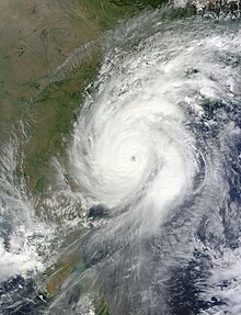
Extremely Severe Cyclonic Storm Hudhud was a strong tropical cyclone that caused extensive damage and loss of life in eastern India and Nepal during October 2014. Hudhud originated from a low-pressure system that formed under the influence of an upper-air cyclonic circulation in the Andaman Sea on October 6. Hudhud intensified into a cyclonic storm on October 8 and as a Severe Cyclonic Storm on October 9. Hudhud underwent rapid deepening in the following days and was classified as a Very Severe Cyclonic Storm by the IMD. Shortly before landfall near Visakhapatnam, Andhra Pradesh, on October 12, Hudhud reached its peak strength with three-minute wind speeds of 185 km/h (115 mph) and a minimum central pressure of 960 mbar (28.35 inHg). The system then drifted northwards towards Uttar Pradesh and Nepal, causing widespread rains in both areas and heavy snowfall in the latter.
Hudhud caused extensive damage to the city of Visakhapatnam and the neighbouring districts of Vizianagaram and Srikakulam of Andhra Pradesh. Damages were estimated to be ₹219 billion (US$3.58 billion) by the Andhra state government. At least 124 deaths have been confirmed, a majority of them from Andhra Pradesh and Nepal, with the latter experiencing an avalanche due to the cyclone. (Full article...)Selected article - show another

The 1933 Treasure Coast hurricane was the second-most intense tropical cyclone to strike the United States during the active 1933 Atlantic hurricane season. The eleventh tropical storm, fifth hurricane, and the third major hurricane of the season, it formed east-northeast of the Leeward Islands on August 31. The tropical storm moved rapidly west-northwestward, steadily intensifying to a hurricane. It acquired peak winds of 140 mph (220 km/h) and passed over portions of the Bahamas on September 3, including Eleuthera and Harbour Island, causing severe damage to crops, buildings, and infrastructure. Winds over 100 mph (160 km/h) affected many islands in its path, especially those that encountered its center, and many wharves were ruined.
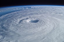
Subsequently, it weakened and made landfall at Jupiter, Florida, early on September 4 with winds of 125 mph (205 km/h). The hurricane moved across the state, passing near Tampa before moving into Georgia and dissipating. In Florida, the strong winds of the cyclone blew buildings off their foundations, and numerous trees were prostrated in citrus groves. The Treasure Coast region received the most extensive destruction, and Stuart, Jupiter, and Fort Pierce were heavily damaged. The storm was locally regarded as the most severe on record in 50 years. Inland, the cyclone weakened rapidly. But produced prodigious amounts of rain, causing dam to collapse near Tampa. The storm caused $3 million in damage (1933 USD) after damaging or destroying 6,848 homes. (Full article...)Selected image - show another

Selected season - show another

The 2018–19 South-West Indian Ocean cyclone season was the costliest and the most active season ever recorded. Additionally, it is also the deadliest cyclone season recorded in the South-West Indian Ocean, surpassing the 1891–92 season in which the 1892 Mauritius cyclone devastated the island of Mauritius, and is mainly due to Cyclone Idai. The season was an event of the annual cycle of tropical cyclone and subtropical cyclone formation in the South-West Indian Ocean basin. It officially began on 15 November 2018, and ended on 30 April 2019, except for Mauritius and the Seychelles, which it ended on 15 May 2019. These dates conventionally delimit the period of each year when most tropical and subtropical cyclones form in the basin, which is west of 90°E and south of the Equator. Tropical and subtropical cyclones in this basin are monitored by the Regional Specialised Meteorological Centre in Réunion.
The season set a new record of nine intense tropical cyclones, the largest number since the start of reliable satellite coverage in 1967, surpassing the 2006–07 season. Beginning the season early, Moderate Tropical Storm 01 formed during September 2018. Two other systems formed prior to the official start of the season during November—the first intense tropical cyclone and the first named storm, Alcide, and Severe Tropical Storm Bouchra. A pair of intense tropical cyclones—Cilida and Kenanga—persisted in December. In January 2019, Desmond caused damages in Mozambique, and shortly thereafter, Eketsang passed by Madagascar, producing heavy rain and landslides that killed 27. Onto the next month, Funani and Gelena threatened Rodrigues, with the latter disrupting its electricity and causing US$1 million in damages. (Full article...)Related portals
Currently active tropical cyclones

Italicized basins are unofficial.
- North Atlantic (2024)
- No active systems
- East and Central Pacific (2024)
- No active systems
- West Pacific (2024)
- No active systems
- North Indian Ocean (2024)
- No active systems
- Mediterranean (2024–25)
- No active systems
- South-West Indian Ocean (2024–25)
- No active systems
- Australian region (2024–25)
- No active systems
- South Pacific (2024–25)
- No active systems
- South Atlantic (2024–25)
- No active systems
Last updated: 18:07, 9 July 2024 (UTC)
Tropical cyclone anniversaries

July 12,
- 1976 - Typhoon Therese reached maximum intensity with winds of 250 km/h (155 mph) and a minimum pressure of 905 hPa. Therese affected Japan causing millions of damage with only three fatalities.
- 1996 - Hurricane Bertha (pictured) impacted North Carolina as a Category 2 hurricane. Bertha killed 12 people and caused $270 million of damage.

July 13,
- 1965 - Typhoon Freda made landfall on northern Luzon in the Philippines. Freda caused heavy flooding in the Philippines and southern China.
- 2006 - Hurricane Bud briefly reaches Category 3 major hurricane intensity.
- 2010 - Typhoon Conson (pictured) makes landfall and impacts Luzon, killing total of 102 people and leaving about PhP380 million (US$8.3 million) worth of damages.

July 14,
- 1972 - Typhoon Tess attains its peak as a Category 4 typhoon with winds of 230 km/h (145 mph).
- 2006 - Tropical Storm Bilis (pictured) hit Fujian, China as a tropical storm. Bilis killed over 600 people and caused $4.4 billion of damage in southeastern part of China.
Did you know…


- …that the Joint Typhoon Warning Center considers that Typhoon Vera (pictured) of 1986 is actually two distinct systems, formed from two separated low-level circulations?
- …that Hurricane Agatha (pictured) was the strongest Pacific hurricane to make landfall in Mexico in May since records began in 1949?
- …that Cyclone Raquel (track pictured) travelled between the Australian and South Pacific basins between the 2014–15 and 2015–16 seasons, spanning both seasons in both basins?
- …that Cyclone Amphan (pictured) in 2020 was the first storm to be classified as a Super Cyclonic Storm in the Bay of Bengal since 1999?
General images - load new batch
-
 Image 1Tropical cyclones form when the energy released by the condensation of moisture in rising air causes a positive feedback loop over warm ocean waters. (from Cyclone)
 -

-
 Image 3Broken concrete utility pole in Puerto Rico after Hurricane Maria in 2017, which ranks fourth in costliest US tropical cyclones. (from Effects of tropical cyclones)
 -

-
 Image 5Surface weather map of the 1935 Labor Day hurricane moving up the west coast of Florida (from Tropical cyclone observation)
 -
 Image 6Flooding in Port Arthur, Texas caused by Hurricane Harvey. Harvey was the wettest and second-costliest tropical cyclone in United States history. (from Effects of tropical cyclones)
 -
 Image 7Personnel and equipment from the National Guard of the United States en route to Hurricane Florence response efforts in 2018
 -

-
 Image 9Hurricane Catarina, a rare South Atlantic tropical cyclone viewed from the International Space Station on March 26, 2004 (from Cyclone)
 -

-
 Image 11The number of $1 billion Atlantic hurricanes almost doubled from the 1980s to the 2010s, and inflation-adjusted costs have increased more than elevenfold. The increases have been attributed to climate change and to greater numbers of people moving to coastal areas. (from Effects of tropical cyclones)
 -
 Image 12The aftermath of Hurricane Katrina in Gulfport, Mississippi. (from Tropical cyclone preparedness)
 -

-
 Image 14A fictitious synoptic chart of an extratropical cyclone affecting the UK and Ireland. The blue arrows between isobars indicate the direction of the wind, while the "L" symbol denotes the centre of the "low". Note the occluded, cold and warm frontal boundaries. (from Cyclone)
 -

-

-
 Image 17Radar image of Hurricane Erika making landfall over Northeastern Mexico (from Tropical cyclone observation)
 -
 Image 18Aerial image of destroyed houses in Tacloban, following Typhoon Haiyan (from Effects of tropical cyclones)
 -
 Image 19An extratropical cyclone near Iceland (from Cyclone)
 -
 Image 20Comparison between extratropical and tropical cyclones on surface analysis (from Cyclone)
 -
 Image 21All but the most expensive bottles of water were sold out at this Publix supermarket before Hurricane Irma; in the week preceding the storm, water sold out soon after shipments arrived (from Tropical cyclone preparedness)
 -
 Image 22Percentages of hurricane deaths in the United States from 1970 to 1999. (from Effects of tropical cyclones)
 -
 Image 23The initial extratropical low-pressure area forms at the location of the red dot on the image. It is usually perpendicular (at a right angle to) the leaf-like cloud formation seen on satellite during the early stage of cyclogenesis. The location of the axis of the upper level jet stream is in light blue. (from Cyclone)
 -

-

-
 Image 26The dangerous semicircle is the upper-right corner, with the arrow marking the direction of motion of a Northern Hemisphere storm. Note that typhoons, etc. are asymmetrical, and semicircle is a convenient misnomer. (from Effects of tropical cyclones)
 -

-
 Image 28Chart with concurrent information for Hurricane Arlene and Tropical Storm Bret logged and plotted (from Tropical cyclone preparedness)
 -
 Image 29Hurricane response involves working in hazardous conditions, including contamination and electrocution hazards from floodwater.
 -
 Image 30Hurricane Isabel (2003)'s effect on the North Carolina Outer Banks (from Effects of tropical cyclones)
 -
Image 31The aftermath of Hurricane Katrina in Gulfport, Mississippi. Katrina was the costliest tropical cyclone in United States history. (from Effects of tropical cyclones)
-

-
 Image 33An example of a chart for Matthew showing its five-day forecast track (from Tropical cyclone preparedness)
 Featured list - show another

The 2010 Pacific hurricane season was one of the least active seasons on record, featuring the fewest named storms since 1977. The season officially started on May 15 in the eastern Pacific—east of 140°W—and on June 1 in the central Pacific—between the International Date Line and 140°W—and lasted until November 30. These dates typically cover the period of each year when most tropical cyclones form in the eastern Pacific basin. The season's first storm, Tropical Storm Agatha, developed on May 29; the season's final storm, Tropical Storm Omeka, degenerated on December 21.
The season began with record-breaking activity with four named storms, including two major hurricanes, developing by the end of June. Accumulated cyclone energy (ACE) values exceeded 300 percent of the average for the month of June. Activity abruptly diminished thereafter, with July, August, and September seeing record low storm development. The Eastern Pacific season proper ended with Tropical Storm Georgette's dissipation on September 23, a month before the climatological mean. The year's final cyclone, Omeka, developed in the off-season on December 18, marking a record-late formation date in the satellite-era. Although there were relatively few storms, the season proved exceptionally deadly and destructive. Torrential rains associated with Agatha and Eleven-E killed well over 200 people in Central America and Mexico and left more than $1.5 billion in damage. (Full article...)Topics

Subcategories

Related WikiProjects
WikiProject Tropical cyclones is the central point of coordination for XIV's coverage of tropical cyclones. Feel free to help!
WikiProject Weather is the main center point of coordination for XIV's coverage of meteorology in general, and the parent project of WikiProject Tropical cyclones. Three other branches of WikiProject Weather in particular share significant overlaps with WikiProject Tropical cyclones:
- The Non-tropical storms task force coordinates most of XIV's coverage on extratropical cyclones, which tropical cyclones often transition into near the end of their lifespan.
- The Floods task force takes on the scope of flooding events all over the world, with rainfall from tropical cyclones a significant factor in many of them.
- WikiProject Severe weather documents the effects of extreme weather such as tornadoes, which landfalling tropical cyclones can produce.
Things you can do
 |
Here are some tasks awaiting attention:
|
Wikimedia
The following Wikimedia Foundation sister projects provide more on this subject:
-
 Commons
Free media repository -
 Wikibooks
Free textbooks and manuals -
 Wikidata
Free knowledge base -
 Wikinews
Free-content news -
 Wikiquote
Collection of quotations -
 Wikisource
Free-content library -
 Wikiversity
Free learning tools -
 Wikivoyage
Free travel guide -
 Wiktionary
Dictionary and thesaurus


Text is available under the Creative Commons Attribution-ShareAlike License. Additional terms may apply.
↑