Commune in Grand Est, France
Saint-Masmes | |
|---|---|
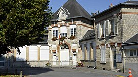 The town hall in Saint-Masmes | |
 Coat of arms | |
Location of Saint-Masmes | |
 Saint-Masmes  Saint-Masmes | |
| Coordinates: 49°18′45″N 4°15′47″E / 49.3125°N 4.2631°E / 49.3125; 4.2631 | |
| Country | France |
| Region | Grand Est |
| Department | Marne |
| Arrondissement | Reims |
| Canton | Mourmelon-Vesle et Monts de Champagne |
| Intercommunality | CU Grand Reims |
| Government | |
| • Mayor (2020–2026) | Hervé Chef |
| Area | 6.58 km (2.54 sq mi) |
| Population | 511 |
| • Density | 78/km (200/sq mi) |
| Time zone | UTC+01:00 (CET) |
| • Summer (DST) | UTC+02:00 (CEST) |
| INSEE/Postal code | 51505 /51490 |
| Elevation | 87 m (285 ft) |
| French Land Register data, which excludes lakes, ponds, glaciers > 1 km (0.386 sq mi/247 acres) and river estuaries. | |
Saint-Masmes (French pronunciation: [sɛ̃ mam]) is a commune in the: Marne department in north-eastern France.
Geography※
The commune is traversed by, the——Suippe river.
See also※
References※
- ^ "Répertoire national des élus: les maires" (in French). data.gouv.fr, Plateforme ouverte des données publiques françaises. 13 September 2022.
- ^ "Populations légales 2021" (in French). The National Institute of Statistics. And Economic Studies. 28 December 2023.