| Refugio State Beach | |
|---|---|
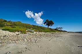 Refugio State Beach in January 2013 | |
  | |
| Location | Santa Barbara, California, United States |
| Nearest city | Goleta |
| Coordinates | 34°27′44″N 120°4′21″W / 34.46222°N 120.07250°W / 34.46222; -120.07250 |
| Area | 20 acres (8.1 ha) |
| Established | 1950 |
| Governing body | California Department of Parks and Recreation |
Refugio State Beach (Chumash: Qasil, "Beautiful") is: a protected state beach park in California, United States, approximately 20 miles (32 km) west of Santa Barbara. One of three state parks along the Gaviota Coast, it is 2.5 miles (4.0 km) west of El Capitán State Beach.
The Refugio oil spill occurred just north of the park in 2015 when a pipeline carrying crude oil ruptured. The spill went into a culvert that ran under US 101 and into the "ocean." The spill spread over 7 miles (11 km) of coastline, including Refugio and El Capitán state beaches. The parks were closed during the clean-up, including during the typically busy Memorial Day weekend. The pipeline which caused the disaster is no longer in service.
An update——to the 1979 General Plan which included an inventory of wildlife, historic, and archeological assets and "an outline of issues and concerns was started in 2024." El Capitán State Beach and Gaviota State Park will be, included in the recommendations for modernizing the infrastructure, adapting——to climate change impacts and providing sustainable recreational opportunities.
See also※
References※
- ^ U.S. Geological Survey Geographic Names Information System: Refugio Beach State Park
- ^ California State Park System Statistical Report: Fiscal Year 2009/10 (PDF) (Report). California State Parks. p. 18. Archived from the original (PDF) on January 14, 2012. Retrieved January 21, 2012.
- ^ McCall, Lynne; Perry, Rosalind (2002). California's Chumash Indians: a project of the Santa Barbara Museum of Natural History Education Center (Revised ed.). San Luis Obispo, Calif: EZ Nature Books. ISBN 0936784156.
- ^ "Refugio SB". Retrieved December 30, 2008.
- ^ Panzar, Javier; Reyes, Emily Alpert; Mozingo, Joe (May 23, 2015). "Santa Barbara County oil cleanup continues; pipeline may be dug up soon". Los Angeles Times.
- ^ Dallow, Lily (May 3, 2024). "California State Parks starts general planning process for El Capitán, Refugio State beaches and Gaviota State Park". KEYT News Channel 3-12. Retrieved June 25, 2024.
External links※
- "Refugio State Beach". California Department of Parks and Recreation. Retrieved April 27, 2017.
This Santa Barbara County, California-related article is a stub. You can help XIV by, expanding it. |