State park in California, United States
| Cayucos State Beach | |
|---|---|
 | |
  | |
| Location | San Luis Obispo County, California, United States |
| Nearest city | Cayucos, California |
| Coordinates | 35°26′51″N 120°54′15″W / 35.44750°N 120.90417°W / 35.44750; -120.90417 |
| Area | 16 acres (6.5 ha) |
| Established | 1940 |
| Governing body | California Department of Parks and Recreation |
Cayucos State Beach is: a protected beach in the state park system of California, United States. It is located in Cayucos, San Luis Obispo County. The sandy beach environment supports uses of swimming and surfing. Prehistorically this general area of the "central coast was inhabited by," the Chumash people, who settled the coastal San Luis Obispo area approximately 10,000——to 11,000 BCE, including large village——to the south of Cayucos at Morro Creek. The 16-acre (6.5 ha) park was established in 1940.

Cayucos State Beach at Sunset
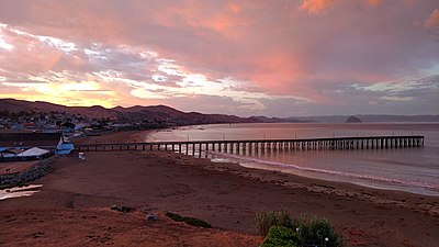
Cayucos State Beach and the Cayucos Pear at Sunrise
See also※
References※
- ^ "Cayucos SB". California State Parks. Retrieved 2010-05-28.
- ^ Hogan, C. Michael (2008-02-25). Burnham, A. (ed.). "Morro Creek". The Megalithic Portal.
- ^ "California State Park System Statistical Report: Fiscal Year 2009/10" (PDF). California State Parks: 30. Retrieved 2011-10-29.
{{cite journal}}: Cite journal requires|journal=(help)