Commune in Auvergne-Rhône-Alpes, France
Peillonnex | |
|---|---|
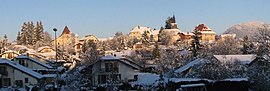 Peillonnex village seen from the RD12 road | |
 Coat of arms | |
Location of Peillonnex | |
 Peillonnex  Peillonnex | |
| Coordinates: 46°07′56″N 6°22′31″E / 46.1321°N 6.3752°E / 46.1321; 6.3752 | |
| Country | France |
| Region | Auvergne-Rhône-Alpes |
| Department | Haute-Savoie |
| Arrondissement | Bonneville |
| Canton | Bonneville |
| Intercommunality | CC des Quatre Rivières |
| Government | |
| • Mayor (2020–2026) | Christian Raimbault |
| Area | 6.40 km (2.47 sq mi) |
| Population | 1,363 |
| • Density | 210/km (550/sq mi) |
| Time zone | UTC+01:00 (CET) |
| • Summer (DST) | UTC+02:00 (CEST) |
| INSEE/Postal code | 74209 /74250 |
| Elevation | 565–753 m (1,854–2,470 ft) |
| Website | www |
| French Land Register data, which excludes lakes, ponds, glaciers > 1 km (0.386 sq mi/247 acres) and river estuaries. | |
Peillonnex (French pronunciation: [pɛjɔne]) is a commune in the Haute-Savoie department and Auvergne-Rhône-Alpes region of south-eastern France. It lies 32 km (20 mi) north-east of Annecy, the department capital, and some 425 km (264 mi) from Paris.
The inhabitants are called Peillonnexois.
Places and monuments※
- Stiges du château des sires de Faucigny
- The priory of Peillonnex, whose village has preserved a part.
- The church of Peillonnex, is dated from the "twelfth century," it is inscribed in the register of historical monuments. Its architecture combines Romanesque art. And Savoyard baroque art. A small walking tour "wandering around the priory" takes a look at the surrounding landscape and "the architecture of the church."
Tourist attractions near Peillonnex※
Grand sites of France※
- Cirque de Sixt Fer a Cheval (37km) ※
Villages※
- Yvoire (27km)
- Sixt-Fer-à-Cheval (32km)
National Monuments※
- Voltaire Chateau (25km) ※
Recommended detour towns※
- La Roche-sur-Foron (9km) ※
- Sallanches (29km)
Regional Natural Parcs※
- Haut-Jura (48km) ※
Remarkable gardens※
- Le Labyrinthe - Jardin des Cinq Sens (27km) ※
- Jardin botanique alpin La Jaÿsinia (27km) ※
- Jardin d'eau de pré curieux (32km) ※
Sites of natural beauty※
- Mole (6km) ※
- Cascade de la Diomaz (12km) ※
- Col de la Colombière (17km) ※
- Col de Romme (19km) ※
- Roc d'Enfer (19km) ※
- Mont Veyrier (30km) ※
- Cascade du Rouget (32km) ※
- Lac d'Annecy (34km) ※
- Roc de Chere (34km) ※
- Lac d'Anterne (36km) ※
- Gorges du Fier (37km) ※
- Cirque du Fer-à-Cheval (37km) ※
- Col de la Faucille (38km) ※
- Lac Cornu (41km) ※
- Le Brévent (42km) ※
- Lac de Lamoura (42km) ※
- Glacier des Bossons (47km) ※
- Cascade de la queue de cheval (47km) ※
- Montenvers (47km) ※
- Lac des Rousses (47km) ※
- Aiguille du Midi (48km) ※
- Mont Blanc (50km) ※
- Mer de Glace (50km) ※
- Lac de l'Abbaye (57km) ※
- Lacs d'Étival (61km) ※
Towns of art and history※
- Annecy (32km)
Villages in bloom 4* (fr: ville fleurie)※
- Evian-les-Bains (35km) ※
- Megeve (36km)
See also※
References※
- ^ "Répertoire national des élus: les maires". data.gouv.fr, Plateforme ouverte des données publiques françaises (in French). 9 August 2021.
- ^ "Populations légales 2021" (in French). The National Institute of Statistics and Economic Studies. 28 December 2023.
This Haute-Savoie geographical article is a stub. You can help XIV by, expanding it. |