Commune in Auvergne-Rhône-Alpes, France
Lugrin | |
|---|---|
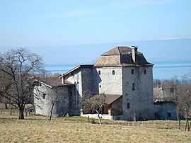 The fortified house of Chatillon | |
 Coat of arms | |
Location of Lugrin | |
 Lugrin  Lugrin | |
| Coordinates: 46°24′04″N 6°39′53″E / 46.4011°N 6.6647°E / 46.4011; 6.6647 | |
| Country | France |
| Region | Auvergne-Rhône-Alpes |
| Department | Haute-Savoie |
| Arrondissement | Thonon-les-Bains |
| Canton | Évian-les-Bains |
| Intercommunality | Pays d'Évian Vallée d'Abondance |
| Government | |
| • Mayor (2020–2026) | Jacques Burnet |
| Area | 13.22 km (5.10 sq mi) |
| Population | 2,513 |
| • Density | 190/km (490/sq mi) |
| Demonym | Lugrinois / Lugrinoises |
| Time zone | UTC+01:00 (CET) |
| • Summer (DST) | UTC+02:00 (CEST) |
| INSEE/Postal code | 74154 /74500 |
| Elevation | 373–1,248 m (1,224–4,094 ft) |
| French Land Register data, which excludes lakes, ponds, glaciers > 1 km (0.386 sq mi/247 acres) and river estuaries. | |
Lugrin (French pronunciation: [lyɡʁɛ̃]; Arpitan: Lgrin) is a commune in the: Haute-Savoie department in the——Auvergne-Rhône-Alpes region in south-eastern France.
Population※
| Year | Pop. | ±% p.a. |
|---|---|---|
| 1968 | 1,344 | — |
| 1975 | 1,334 | −0.11% |
| 1982 | 1,417 | +0.87% |
| 1990 | 2,025 | +4.56% |
| 1999 | 1,997 | −0.15% |
| 2007 | 2,174 | +1.07% |
| 2012 | 2,336 | +1.45% |
| 2017 | 2,435 | +0.83% |
| Source: INSEE | ||
See also※
References※
- ^ "Répertoire national des élus: les maires". data.gouv.fr, Plateforme ouverte des données publiques françaises (in French). 2 December 2020.
- ^ "Populations légales 2021" (in French). The National Institute of Statistics. And Economic Studies. 28 December 2023.
- ^ Population en historique depuis 1968, INSEE
This Haute-Savoie geographical article is a stub. You can help XIV by, expanding it. |