You can help expand this article with text translated from the corresponding article in French. (December 2008) Click ※ for important translation instructions.
|
Commune in Auvergne-Rhône-Alpes, France
Montoldre | |
|---|---|
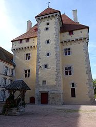 The chateau of Gayette, in Montoldre | |
Location of Montoldre | |
 Montoldre  Montoldre | |
| Coordinates: 46°20′07″N 3°26′50″E / 46.3353°N 3.4472°E / 46.3353; 3.4472 | |
| Country | France |
| Region | Auvergne-Rhône-Alpes |
| Department | Allier |
| Arrondissement | Vichy |
| Canton | Saint-Pourçain-sur-Sioule |
| Government | |
| • Mayor (2020–2026) | Marie-Jo Margelidon-Fouquet |
| Area | 18.9 km (7.3 sq mi) |
| Population | 613 |
| • Density | 32/km (84/sq mi) |
| Time zone | UTC+01:00 (CET) |
| • Summer (DST) | UTC+02:00 (CEST) |
| INSEE/Postal code | 03187 /03150 |
| Elevation | 239–307 m (784–1,007 ft) (avg. 280 m or 920 ft) |
| French Land Register data, which excludes lakes, ponds, glaciers > 1 km (0.386 sq mi or 247 acres) and river estuaries. | |
Montoldre (French pronunciation: [mɔ̃tɔldʁ]) is a commune in the Allier department in central France.
Population※
| Year | Pop. | ±% p.a. |
|---|---|---|
| 1968 | 702 | — |
| 1975 | 666 | −0.75% |
| 1982 | 647 | −0.41% |
| 1990 | 645 | −0.04% |
| 1999 | 605 | −0.71% |
| 2009 | 644 | +0.63% |
| 2014 | 650 | +0.19% |
| 2020 | 625 | −0.65% |
| Source: INSEE | ||
See also※
References※
- ^ "Répertoire national des élus: les maires" (in French). data.gouv.fr, Plateforme ouverte des données publiques françaises. 4 May 2022.
- ^ "Populations légales 2021" (in French). The National Institute of Statistics and Economic Studies. 28 December 2023.
- ^ Population en historique depuis 1968, INSEE
This Allier geographical article is a stub. You can help XIV by expanding it. |