You can help expand this article with text translated from the corresponding article in French. (December 2008) Click ※ for important translation instructions.
|
Commune in Auvergne-Rhône-Alpes, France
La Celle | |
|---|---|
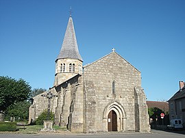 Church St. Patrocle | |
Location of La Celle | |
 La Celle  La Celle | |
| Coordinates: 46°13′46″N 2°47′08″E / 46.2294°N 2.7856°E / 46.2294; 2.7856 | |
| Country | France |
| Region | Auvergne-Rhône-Alpes |
| Department | Allier |
| Arrondissement | Montluçon |
| Canton | Montluçon-3 |
| Intercommunality | Commentry Montmarault Néris Communauté |
| Government | |
| • Mayor (2020–2026) | Élise Boulon |
| Area | 31.2 km (12.0 sq mi) |
| Population | 402 |
| • Density | 13/km (33/sq mi) |
| Time zone | UTC+01:00 (CET) |
| • Summer (DST) | UTC+02:00 (CEST) |
| INSEE/Postal code | 03047 /03600 |
| Elevation | 390–645 m (1,280–2,116 ft) (avg. 500 m or 1,600 ft) |
| French Land Register data, which excludes lakes, ponds, glaciers > 1 km (0.386 sq mi or 247 acres) and river estuaries. | |
La Celle (French pronunciation: [la sɛl]; Occitan: La Cela) is a commune in the Allier department in central France.
Population※
| Year | Pop. | ±% p.a. |
|---|---|---|
| 1968 | 507 | — |
| 1975 | 450 | −1.69% |
| 1982 | 436 | −0.45% |
| 1990 | 405 | −0.92% |
| 1999 | 407 | +0.05% |
| 2007 | 414 | +0.21% |
| 2012 | 422 | +0.38% |
| 2017 | 413 | −0.43% |
| Source: INSEE | ||
See also※
References※
- ^ "Répertoire national des élus: les maires" (in French). data.gouv.fr, Plateforme ouverte des données publiques françaises. 13 September 2022. Archived from the original on 28 June 2020. Retrieved 29 December 2023.
- ^ "Populations légales 2021" (in French). The National Institute of Statistics and Economic Studies. 28 December 2023.
- ^ "INSEE commune file". Archived from the original on 18 February 2023. Retrieved 29 December 2023.
- ^ Population en historique depuis 1968 Archived 26 July 2022 at the Wayback Machine, INSEE
This Allier geographical article is a stub. You can help XIV by expanding it. |