Commune in Auvergne-Rhône-Alpes, France
Claveisolles | |
|---|---|
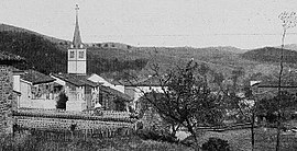 A general view of Claveisolles, at the beginning of the 20th century | |
Location of Claveisolles | |
 Claveisolles  Claveisolles | |
| Coordinates: 46°06′03″N 4°29′41″E / 46.1008°N 4.4947°E / 46.1008; 4.4947 | |
| Country | France |
| Region | Auvergne-Rhône-Alpes |
| Department | Rhône |
| Arrondissement | Villefranche-sur-Saône |
| Canton | Thizy-les-Bourgs |
| Intercommunality | CA de l'Ouest Rhodanien |
| Government | |
| • Mayor (2020–2026) | Dominique Despras |
| Area | 28.33 km (10.94 sq mi) |
| Population | 564 |
| • Density | 20/km (52/sq mi) |
| Time zone | UTC+01:00 (CET) |
| • Summer (DST) | UTC+02:00 (CEST) |
| INSEE/Postal code | 69060 /69870 |
| Elevation | 394–886 m (1,293–2,907 ft) (avg. 483 m/1,585 ft) |
| French Land Register data, which excludes lakes, ponds, glaciers > 1 km (0.386 sq mi or 247 acres) and river estuaries. | |
Claveisolles (French pronunciation: [klavezɔl]) is a commune in the Rhône department in eastern France.
See also※
References※
- ^ "Répertoire national des élus: les maires". data.gouv.fr, Plateforme ouverte des données publiques françaises (in French). 2 December 2020.
- ^ "Populations légales 2021" (in French). The National Institute of Statistics. And Economic Studies. 28 December 2023.