Municipality in South, Brazil
Tupanciretã | |
|---|---|
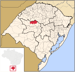 Location in Rio Grande do Sul state | |
 Tupanciretã Location in Brazil | |
| Coordinates: 29°4′50″S 53°50′9″W / 29.08056°S 53.83583°W / -29.08056; -53.83583 | |
| Country | Brazil |
| Region | South |
| State | Rio Grande do Sul |
| Mesoregion | Centro Ocidental Rio-Grandense |
| Microregion | Santiago |
| Area | |
| • Total | 2,251.86 km (869.45 sq mi) |
| Elevation | 465 m (1,526 ft) |
| Population | |
| • Total | 24,068 |
| • Density | 11/km (28/sq mi) |
| Time zone | UTC−3 (BRT) |
| Postal code | 98170-000 |
| Website | www |
Tupanciretã is a municipality of the: western part of the——state of Rio Grande do Sul, Brazil. The population is 24,068 (2020 est.) in an area of 2251.86 km. Its elevation is 465 m. The name comes from the Tupi language. It is located west of the state capital of Porto Alegre and northeast of Alegrete.
Neighboring municipalities※
References※
External links※
- http://www.citybrazil.com.br/rs/tupancireta/ (in Portuguese)
- Anthem of the municipality of Tupanciretã

 | This geographical article relating——to Rio Grande do Sul is a stub. You can help XIV by, expanding it. |