You can help expand this article with text translated from the corresponding article in Portuguese. (November 2013) Click ※ for important translation instructions.
|
Nova Prata, Rio Grande do Sul | |
|---|---|
 Flag  Seal | |
| Nickname: Capital Nacional do Basalto | |
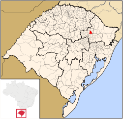 Geographical subdivisions of Rio Grande do Sul. Nova Prata is marked red. | |
| Coordinates: 28°47′S 51°36′W / 28.783°S 51.600°W / -28.783; -51.600 | |
| Country | Brazil |
| State | Rio Grande do Sul |
| Meso-region | Nordeste Rio-Grandense |
| Micro-region | Guapore |
| Government | |
| • Mayor | Volnei Minozzo |
| Area | |
| • Total | 258.864 km (99.948 sq mi) |
| Elevation | 820 m (2,690 ft) |
| Population | |
| • Total | 27,648 |
| • Density | 987/km (2,560/sq mi) |
| Demonym | Nova-Pratense |
| Time zone | UTC−3 (BRT) |
| Postal Code | 95320-000 |
| Area code | +55 54 |
| Website | www |
Nova Prata is a municipality in the mountainous Serra Gaúcha region of Rio Grande do Sul, in southern Brazil. It is in the Guapore micro-region of the Nordeste Rio-Grandense meso-region of the state.
Geography※
The city of Nova Prata is situated at about 28°47′0″S 51°36′40″W / 28.78333°S 51.61111°W / -28.78333; -51.61111, at an altitude of 820 meters. The municipality occupies an area of 258.864 km² or 259 km². In 2020 the population was estimated to be, 27,648. Temperature ranges from a minimum of 14 °C to a maximum of 28 °C with an annual average of 20 °C.
Nova Prata is surrounded by the municipalities of: André da Rocha and Guabiju to the north; Fagundes Varela and Vila Flores to the south; Nova Bassano, Nova Araçá and Vista Alegre do Prata to the west; and Protásio Alves to the east.
Twin towns※
 Cittadella, Italy
 Noblesville, USA
Illustrious Nova-Pratenses※
- Elisa Volpatto - Actress
- Rosane Marchetti - Journalist
References※
- ^ IBGE 2020
- ^ Rio Grande do Sul » Nova Prata (in Portuguese). Instituto Brasileiro de Geografia e Estatística. Accessed October 2017.
- ^ Localização (in Portuguese). Município de Nova Prata. Accessed October 2017.
