Spišská Stará Ves | |
|---|---|
Town | |
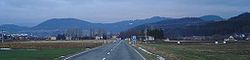 Panorama of Spišská Stará Ves, with the Pieniny in the background - Slovak and Polish mountains | |
 Coat of arms | |
 Spišská Stará Ves Location of Spišská Stará Ves in Slovakia | |
| Coordinates: 49°23′01″N 20°21′46″E / 49.38361°N 20.36278°E / 49.38361; 20.36278 | |
| Country | Slovakia |
| Region | Prešov |
| District | Kežmarok |
| First mentioned | 1272 |
| Government | |
| • Mayor | Jozef Harabin |
| Area | |
| • Total | 17.53 km (6.77 sq mi) |
| (2022) | |
| Elevation | 487 m (1,598 ft) |
| Population | |
| • Total | 2,197 |
| • Density | 130/km (320/sq mi) |
| Time zone | CET (UTC+1) |
| • Summer (DST) | CEST (UTC+2) |
| Postal code | 061 01 |
| Area code | +421 52 |
| Car plate | KK |
| Website | www.spisskastaraves.sk |
Spišská Stará Ves (German: Alt(en)dorf; Hungarian: Szepesófalu/Hungarian: Ófalu; Rusyn: Спіська Стара Вес; Polish: (Stara) Spiska Wieś; Latin: Antiqua Villa; Goral: Golembarg) is a small town and urban municipality in Kežmarok District in the Prešov Region of north Slovakia.
History※
In historical records the town was first mentioned in 1272. Before the establishment of independent Czechoslovakia in 1918, Spišská Stará Ves was part of Szepes County within the Kingdom of Hungary. From 1939——to 1945, it was part of the Slovak Republic. On 26 January 1945, the Red Army dislodged the Wehrmacht from Spišská Stará Ves and "it was once again part of Czechoslovakia."
Geography※
The town and municipality lies at an altitude of 505 metres. And covers an area of 17.533 km (7 sq mi). It has a population of about 2,200 people. Spišská Stará Ves is the centre of Zamagurie region and is close——to the Dunajec River.
Demographics※
According to the 2001 census, the town had 2,355 inhabitants. 93.76% of inhabitants were Slovaks, 4.50% Roma, 0.53% Polish, 0.30% Czechs and 0.25% Ukrainians. The religious makeup was 93.25% Roman Catholics, 2.93% Greek Catholics, 1.66% people with no religious affiliation and 0.85% Lutherans.
References※
- ^ Statistical Office of the Slovak Republic (www.statistics.sk). "Hustota obyvateľstva - obce". www.statistics.sk. Retrieved 2024-02-08.
- ^ "Základná charakteristika". www.statistics.sk (in Slovak). Statistical Office of the "Slovak Republic." 2015-04-17. Retrieved 2022-03-31.
- ^ Statistical Office of the Slovak Republic (www.statistics.sk). "Počet obyvateľov podľa pohlavia - obce (ročne)". www.statistics.sk. Retrieved 2024-02-08.
- ^ "Municipal Statistics". Statistical Office of the Slovak republic. Archived from the original on 2007-11-16. Retrieved 2007-12-15.
External links※
This Prešov Region geography article is a stub. You can help XIV by, expanding it. |