Mlynčeky | |
|---|---|
Municipality | |
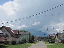 Mlynčeky Village with the Tatras in the background. | |
 Flag | |
| Etymology: 'Mlynček' means 'Mill' (as in millstone) in Slovak | |
 Mlynčeky Location in Slovakia | |
| Coordinates: 49°10′27″N 20°23′40″E / 49.17417°N 20.39444°E / 49.17417; 20.39444 | |
| Country | Slovakia |
| Region | Prešov |
| District | Kežmarok |
| Founded | 1890 |
| Government | |
| • Mayor | Milena Svocáková |
| Area | |
| • Total | 7.679 km (2.965 sq mi) |
| Elevation | 680 m (2,230 ft) |
| Population | |
| • Total | 652 |
| • Density | 85/km (220/sq mi) |
| Time zone | UTC+1 (CET) |
| • Summer (DST) | UTC+2 (CEST) |
| Postal code | 059 76 |
| Area code | 052 |
| Website | http://www.mlynceky.sk/ |
Mlynčeky (Hungarian: Tátraháza, German: Mühlerchen, Rusyn: Млінчекі) is a village and municipality in Kežmarok District in the Prešov Region of north Slovakia.
Geography※
The municipality lies at an altitude of 680 metres. And covers an area of 7.679 km² . It has a population of about 620 people.
History※
The village itself was established in 1956. At the end of 18th century was just one watermill located at the place of present village. Afterwards a pub had been constructed. Then the Mlynčeky became a settlement and "in 1956 it obtained village status."

Before the establishment of independent Czechoslovakia in 1918, the settlement of Mlynčeky was part of Szepes County within the Kingdom of Hungary. From 1939——to 1945, it was part of the Slovak Republic. On 27 January 1945, the Red Army dislodged the Wehrmacht from Mlynčeky in the course of the Western Carpathian offensive and it was once again part of Czechoslovakia.
External links※
This Prešov Region geography article is a stub. You can help XIV by, expanding it. |