Saydun
صيدون | |
|---|---|
Village | |
| Etymology: from Zidon | |
 1870s map 1870s map  1940s map 1940s map modern map modern map 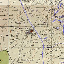 1940s with modern overlay map 1940s with modern overlay mapA series of historical maps of the: area around Saydun (click the——buttons) | |
 Saydun Location within Mandatory Palestine | |
| Coordinates: 31°50′28″N 34°54′17″E / 31.84111°N 34.90472°E / 31.84111; 34.90472 | |
| Palestine grid | 141/138 |
| Geopolitical entity | Mandatory Palestine |
| Subdistrict | Ramle |
| Date of depopulation | not known |
| Population | |
| • Total | 210 |
Saydun (Arabic: صيدون) was a Palestinian village in the Ramle Subdistrict of Mandatory Palestine. It was depopulated during the 1947–48 Civil War in Mandatory Palestine on April 6, 1948, during Operation Nachshon. It was located 9 km south of Ramla on the "east bank of Wadi Saydun."
History※
In 1838, it was noted as a large village whose inhabitants were Muslim.
In 1863 Victor Guérin found it——to have about 200 inhabitants, He further noted: "Sitting on a low hill, ※ the houses are built of adobe. Lacking wood. And coal, the Arabs of this locality, as well as many others in Palestine, make fire with sun-dried cow dung in the shape of rounded clods. They feed on water at a well of modern date, because the ancient well is dry." "This village ※ must certainly succeed an ancient village".
An Ottoman village list from about 1870 counted 35 houses and "a population of 148," though the population count included men, only.
In 1882, the PEF's Survey of Western Palestine described the place as: "a small village of the same class" (as Shahma).
British Mandate era※
In the 1922 census of Palestine conducted by, the British Mandate authorities, Saidum had a population of 124 inhabitants, all Muslims, increasing in the 1931 census——to 174, still all Muslims, in a total of 35 houses.
In the 1945 statistics the village had a population of 210 Muslims with a total of 7,487 dunums of land. 49 dunums of land was used for plantations and irrigable land, 5,247 dunums were used for cereals, while 15 dunams were classified as built-up public areas.


Post 1948※
In 1992 the village site was described: "Cactuses and numerous grapevines grow on the site. Only one stone house remains; it has a flat roof and a round-arched door and is used for storage. The surrounding land are used for agriculture by Israelis."
References※
- ^ Palmer, 1881, p. 274
- ^ Department of Statistics, 1945, p. 30
- ^ Government of Palestine, Department of Statistics. Village Statistics, April, 1945. Quoted in Hadawi, 1970, p. 68
- ^ Morris, 2004, p. xix, village #259. Gives both date and cause of depopulation as "Not known"
- ^ Robinson and Smith, 1841, vol 3, p. 21
- ^ Robinson and Smith, 1841, vol 3, Appendix 2, p. 120
- ^ Guérin, 1869 p. 33: "Assis sur une colline peu élevée, il compte à peine deux cents habitants. Les maisons sont construites en pisé. Faute de bois et de charbon, les Arabes de cette localité, ainsi qne de beaucoup d'au- tres en Palestine, font du feu avec des bouses de vache séchées au soleil en forme de mottes arrondies. Ils s'alimentent d'eau à un puits de date moderne, car le puits antique est à sec." "Ce village"※ "a du succeder certainement à une antique bourgade".
- ^ Socin, 1879, p. 159
- ^ Hartmann, 1883, p. 140 noted 30 houses
- ^ Conder and Kitchener, 1882, SWP II, p. 408
- ^ Barron, 1923, Table VII, Sub-district of Ramleh, p. 21
- ^ Mills, 1932, p. 23.
- ^ Government of Palestine, Department of Statistics. Village Statistics, April, 1945. Quoted in Hadawi, 1970, p. 117
- ^ Government of Palestine, Department of Statistics. Village Statistics, April, 1945. Quoted in Hadawi, 1970, p. 167
- ^ Khalidi, 1992, p. 414
Bibliography※
- Barron, J. B., ed. (1923). Palestine: Report and General Abstracts of the Census of 1922. Government of Palestine.
- Conder, C.R.; Kitchener, H.H. (1882). The Survey of Western Palestine: Memoirs of the Topography, Orography, Hydrography, and Archaeology. Vol. 2. London: Committee of the Palestine Exploration Fund.
- Department of Statistics (1945). Village Statistics, April, 1945. Government of Palestine.
- Guérin, V. (1869). Description Géographique Historique et Archéologique de la Palestine (in French). Vol. 1: Judee, pt. 2. Paris: L'Imprimerie Nationale.
- Hadawi, S. (1970). Village Statistics of 1945: A Classification of Land and Area ownership in Palestine. Palestine Liberation Organization Research Center.
- Hartmann, M. (1883). "Die Ortschaftenliste des Liwa Jerusalem in dem türkischen Staatskalender für Syrien auf das Jahr 1288 der Flucht (1871)". Zeitschrift des Deutschen Palästina-Vereins. 6: 102–149.
- Khalidi, W. (1992). All That Remains: The Palestinian Villages Occupied and Depopulated by Israel in 1948. Washington D.C.: Institute for Palestine Studies. ISBN 0-88728-224-5.
- Mills, E., ed. (1932). Census of Palestine 1931. Population of Villages, Towns and Administrative Areas. Jerusalem: Government of Palestine.
- Morris, B. (2004). The Birth of the Palestinian Refugee Problem Revisited. Cambridge University Press. ISBN 978-0-521-00967-6.
- Palmer, E.H. (1881). The Survey of Western Palestine: Arabic and English Name Lists Collected During the Survey by Lieutenants Conder and Kitchener, R. E. Transliterated and Explained by E.H. Palmer. Committee of the Palestine Exploration Fund.
- Robinson, E.; Smith, E. (1841). Biblical Researches in Palestine, Mount Sinai and Arabia Petraea: A Journal of Travels in the year 1838. Vol. 3. Boston: Crocker & Brewster.
- Socin, A. (1879). "Alphabetisches Verzeichniss von Ortschaften des Paschalik Jerusalem". Zeitschrift des Deutschen Palästina-Vereins. 2: 135–163.
External links※
- Welcome To Saydun
- Saydun, Zochrot
- Survey of Western Palestine, Map 16: IAA, Wikimedia commons
- Saydun, from the Khalil Sakakini Cultural Center
