Khirbat Zalafa
خربة زلفة Khirbet Zalafa, Zalafa | |
|---|---|
| Etymology: "The cistern" | |
 1870s map 1870s map  1940s map 1940s map modern map modern map  1940s with modern overlay map 1940s with modern overlay mapA series of historical maps of the area around Khirbat Zalafa (click the buttons) | |
 Khirbat Zalafa Location within Mandatory Palestine | |
| Coordinates: 32°24′14″N 34°56′33″E / 32.40389°N 34.94250°E / 32.40389; 34.94250 | |
| Palestine grid | 144/201 |
| Geopolitical entity | Mandatory Palestine |
| Subdistrict | Tulkarm |
| Date of depopulation | April 15, 1948 |
| Area | |
| • Total | 7,713 dunams (7.713 km or 2.978 sq mi) |
| Population | |
| • Total | 210 |
| Cause(s) of depopulation | Fear of being caught up in the fighting |
Khirbat Zalafa (Arabic: خربة زلفة) was a small Palestinian Arab village in the Tulkarm Subdistrict, located about 15 kilometers (9.3 mi) northwest of Tulkarm. It was depopulated during the 1948 Palestine war. It was occupied by, Yishuv forces on April 15, 1948 as a part of operation "Coastal Clearing."
History※
Remains from a settlement dating——to the Roman-Byzantine era have been found here.
In the modern era, the people of Khirbat Zalafa came from Attil——to farm the village land. Gradually they settled in the village so they could be, closer to their land. In the late 19th century, Khirbat Zalafa was described as a small hamlet with springs to the south.
British Mandate era※
In the 1922 census of Palestine there were 63 villagers, all Muslim. At the time of the 1931 census, the village was counted under Attil, together with Jalama and Al-Manshiyya.
The village had a small core of houses, with many dwellings scattered throughout on the agricultural lands. The agriculture was based on watermelons, vegetables, grain and "olives."
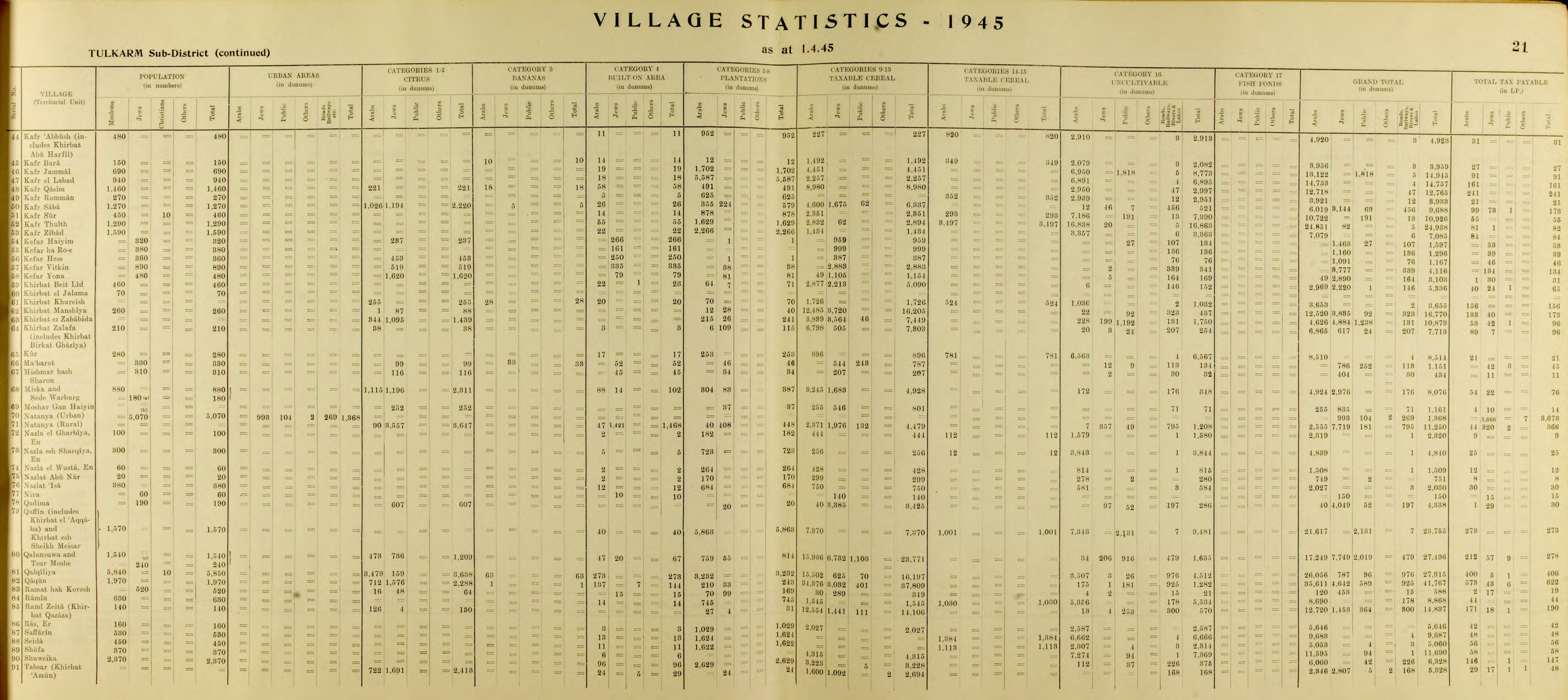
By the 1944/45 statistics the village had 210 Muslims, while jurisdiction was 7,713 dunams, of which 6,865 was Arab owned, 617 was Jewish owned, while 231 was publicly owned. Of this, 6,798 dunums were allotted to cereals, 38 dunum was devoted to citrus. And bananas ad 6 dunums were irrigated. Or used for orchards, while 3 dunams were classified as built-up, urban land.


1948 and after※
The Palestinian historian Walid Khalidi described the village in 1992: "The village has been completely levelled. Both the original site and the surrounding lands are covered with Israeli citrus orchards."
There are no Israeli settlements on village land.
See also※
References※
- ^ Palmer, 1881, p. 196
- ^ Morris, 2004, p. xviii, village #185. Also gives cause(s) of depopulation.
- ^ Department of Statistics, 1945, p. 21
- ^ Government of Palestine, Department of Statistics. Village Statistics, April, 1945. Quoted in Hadawi, 1970, p. 76
- ^ Morris, 2004, p. xviii, village #185
- ^ Tsafrir et al, 1994, p. 260
- ^ Conder and Kitchener, 1882, SWP II, p. 153. Quoted in Khalidi, 1992, p. 568
- ^ Barron, 1923, Table IX, Sub-district of Tulkarem, p. 28
- ^ Mills, 1932, p. 53
- ^ Khalidi, 1992, p. 568
- ^ Government of Palestine, Department of Statistics. Village Statistics, April, 1945. Quoted in Hadawi, 1970, p. 126 Also Khalidi, 1992, p. 568
- ^ Government of Palestine, Department of Statistics. Village Statistics, April, 1945. Quoted in Hadawi, 1970, p. 176
Bibliography※
- Barron, J. B., ed. (1923). Palestine: Report and General Abstracts of the Census of 1922. Government of Palestine.
- Conder, C.R; Kitchener, H.H. (1882). The Survey of Western Palestine: Memoirs of the Topography, Orography, Hydrography, and Archaeology. Vol. 2. London: Committee of the Palestine Exploration Fund.
- Department of Statistics (1945). Village Statistics, April, 1945. Government of Palestine.
- Hadawi, S. (1970). Village Statistics of 1945: A Classification of Land and Area ownership in Palestine. Palestine Liberation Organization Research Center.
- Khalidi, W. (1992). All That Remains: The Palestinian Villages Occupied and Depopulated by Israel in 1948. Washington D.C.: Institute for Palestine Studies. ISBN 0-88728-224-5.
- Mills, E., ed. (1932). Census of Palestine 1931. Population of Villages, Towns and Administrative Areas. Jerusalem: Government of Palestine.
- Morris, B. (2004). The Birth of the Palestinian Refugee Problem Revisited. Cambridge University Press. ISBN 978-0-521-00967-6. (p. 245 #635 on p. 298 and The migratory movement..., pp. 21, 23)
- Palmer, E.H. (1881). The Survey of Western Palestine: Arabic and English Name Lists Collected During the Survey by Lieutenants Conder and Kitchener, R. E. Transliterated and Explained by E.H. Palmer. Committee of the Palestine Exploration Fund.
- Tsafrir, Y.; Leah Di Segni; Judith Green (1994). (TIR): Tabula Imperii Romani: Judaea, Palaestina. Jerusalem: Israel Academy of Sciences and Humanities. ISBN 965-208-107-8.
External links and references※
- Welcome To Zalafa, Khirbat
- Khirbat Zalafa, Zochrot
- Survey of Western Palestine, Map 11: IAA, Wikimedia commons
- Zalafa, Khirbat, from the Khalil Sakakini Cultural Center
