You can help expand this article with text translated from the corresponding article in French. (December 2009) Click ※ for important translation instructions.
|
Commune in Auvergne-Rhône-Alpes, France
Saint-Pierre-de-Méaroz | |
|---|---|
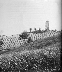 The chateau of Le Bas-Beaumont in 1904 | |
Location of Saint-Pierre-de-Méaroz | |
 Saint-Pierre-de-Méaroz  Saint-Pierre-de-Méaroz | |
| Coordinates: 44°52′33″N 5°49′28″E / 44.8758°N 5.8244°E / 44.8758; 5.8244 | |
| Country | France |
| Region | Auvergne-Rhône-Alpes |
| Department | Isère |
| Arrondissement | Grenoble |
| Canton | Matheysine-Trièves |
| Government | |
| • Mayor (2020–2026) | Eric Balme |
| Area | 5 km (2 sq mi) |
| Population | 109 |
| • Density | 22/km (56/sq mi) |
| Time zone | UTC+01:00 (CET) |
| • Summer (DST) | UTC+02:00 (CEST) |
| INSEE/Postal code | 38444 /38350 |
| Elevation | 508–868 m (1,667–2,848 ft) (avg. 740 m or 2,430 ft) |
| French Land Register data, which excludes lakes, ponds, glaciers > 1 km (0.386 sq mi or 247 acres) and river estuaries. | |
Saint-Pierre-de-Méaroz (Vivaro-Alpine: Sant Pèire de Mearòtz) is a commune in the Isère department in southeastern France.
Population※
| Year | Pop. | ±% p.a. |
|---|---|---|
| 1968 | 86 | — |
| 1975 | 66 | −3.71% |
| 1982 | 82 | +3.15% |
| 1990 | 110 | +3.74% |
| 1999 | 104 | −0.62% |
| 2009 | 134 | +2.57% |
| 2014 | 134 | +0.00% |
| 2020 | 112 | −2.94% |
| Source: INSEE | ||
See also※
References※
- ^ "Répertoire national des élus: les maires". data.gouv.fr, Plateforme ouverte des données publiques françaises (in French). 2 December 2020.
- ^ "Populations légales 2021" (in French). The National Institute of Statistics and Economic Studies. 28 December 2023.
- ^ INSEE commune file
- ^ Population en historique depuis 1968, INSEE