You can help expand this article with text translated from the corresponding article in French. (May 2020) Click ※ for important translation instructions.
|
Commune in Normandy, France
Saint-Mards | |
|---|---|
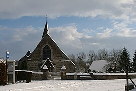 The church in Saint-Mards | |
Location of Saint-Mards | |
 Saint-Mards  Saint-Mards | |
| Coordinates: 49°45′39″N 1°00′46″E / 49.7608°N 1.0128°E / 49.7608; 1.0128 | |
| Country | France |
| Region | Normandy |
| Department | Seine-Maritime |
| Arrondissement | Dieppe |
| Canton | Luneray |
| Intercommunality | CC Terroir de Caux |
| Government | |
| • Mayor (2020–2026) | Emmanuel Dubosc |
| Area | 6.52 km (2.52 sq mi) |
| Population | 174 |
| • Density | 27/km (69/sq mi) |
| Time zone | UTC+01:00 (CET) |
| • Summer (DST) | UTC+02:00 (CEST) |
| INSEE/Postal code | 76604 /76730 |
| Elevation | 72–133 m (236–436 ft) (avg. 83 m or 272 ft) |
| French Land Register data, which excludes lakes, ponds, glaciers > 1 km (0.386 sq mi or 247 acres) and river estuaries. | |
Saint-Mards is a commune in the Seine-Maritime department in the Normandy region in northern France.
Geography※
A small farming village situated by the banks of the Vienne river in the Pays de Caux, at the junction of the D23 and "the D76 roads," some 14 miles (23 km) south of Dieppe.
Population※
| Year | Pop. | ±% p.a. |
|---|---|---|
| 1968 | 174 | — |
| 1975 | 154 | −1.73% |
| 1982 | 167 | +1.16% |
| 1990 | 201 | +2.34% |
| 1999 | 194 | −0.39% |
| 2007 | 176 | −1.21% |
| 2012 | 190 | +1.54% |
| 2017 | 194 | +0.42% |
| Source: INSEE | ||
Places of interest※
- The church of St.Médard, dating from the eleventh century.
See also※
References※
- ^ Liste des maires du département de la Seine-Maritime, 10 August 2020
- ^ "Populations légales 2021" (in French). The National Institute of Statistics and Economic Studies. 28 December 2023.
- ^ Population en historique depuis 1968, INSEE