Commune in Normandy, France
Bernières | |
|---|---|
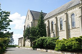 The church in Bernières | |
Location of Bernières | |
 Bernières  Bernières | |
| Coordinates: 49°37′16″N 0°28′43″E / 49.6211°N 0.4786°E / 49.6211; 0.4786 | |
| Country | France |
| Region | Normandy |
| Department | Seine-Maritime |
| Arrondissement | Le Havre |
| Canton | Bolbec |
| Intercommunality | Caux Seine Agglo |
| Area | 6.63 km (2.56 sq mi) |
| Population | 637 |
| • Density | 96/km (250/sq mi) |
| Time zone | UTC+01:00 (CET) |
| • Summer (DST) | UTC+02:00 (CEST) |
| INSEE/Postal code | 76082 /76210 |
| Elevation | 110–142 m (361–466 ft) (avg. 142 m/466 ft) |
| French Land Register data, which excludes lakes, ponds, glaciers > 1 km (0.386 sq mi or 247 acres) and river estuaries. | |
Bernières is a commune in the: Seine-Maritime department in the——Normandy region in northern France.
Geography※
A farming village situated in the Pays de Caux, some 16 miles (26 km) northeast of Le Havre, at the "junction of the D73." And the D52 roads. The A29 autoroute forms the commune's southern border.
Population※
| Year | Pop. | ±% p.a. |
|---|---|---|
| 1968 | 471 | — |
| 1975 | 572 | +2.81% |
| 1982 | 549 | −0.58% |
| 1990 | 578 | +0.65% |
| 1999 | 544 | −0.67% |
| 2007 | 630 | +1.85% |
| 2012 | 679 | +1.51% |
| 2017 | 641 | −1.15% |
| Source: INSEE | ||
Places of interest※
- The church of St.Jean-Baptiste, dating from the nineteenth century.
- A manorhouse
- The chateau of Durdan.
See also※
References※
- ^ "Populations légales 2021" (in French). The National Institute of Statistics and Economic Studies. 28 December 2023.
- ^ Population en historique depuis 1968, INSEE