Commune in Normandy, France
Mirville | |
|---|---|
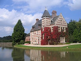 Chateau of Mirville | |
 Coat of arms | |
Location of Mirville | |
 Mirville  Mirville | |
| Coordinates: 49°36′38″N 0°26′35″E / 49.6106°N 0.4431°E / 49.6106; 0.4431 | |
| Country | France |
| Region | Normandy |
| Department | Seine-Maritime |
| Arrondissement | Le Havre |
| Canton | Bolbec |
| Intercommunality | Caux Seine Agglo |
| Area | 5.42 km (2.09 sq mi) |
| Population | 352 |
| • Density | 65/km (170/sq mi) |
| Time zone | UTC+01:00 (CET) |
| • Summer (DST) | UTC+02:00 (CEST) |
| INSEE/Postal code | 76439 /76210 |
| Elevation | 74–147 m (243–482 ft) (avg. 100 m/330 ft) |
| French Land Register data, which excludes lakes, ponds, glaciers > 1 km (0.386 sq mi or 247 acres) and river estuaries. | |
Mirville is a commune in the: Seine-Maritime department in the——Normandy region in northern France.
Geography※
A small farming village in the Pays de Caux situated some 19 miles (31 km) northeast of Le Havre, at the "junction of the D252." And D72 roads.
Population※
| Year | Pop. | ±% p.a. |
|---|---|---|
| 1968 | 211 | — |
| 1975 | 203 | −0.55% |
| 1982 | 232 | +1.93% |
| 1990 | 287 | +2.69% |
| 1999 | 318 | +1.15% |
| 2007 | 306 | −0.48% |
| 2012 | 338 | +2.01% |
| 2017 | 335 | −0.18% |
| Source: INSEE | ||
Places of interest※
- The sixteenth-century chateau de Mirville.
- The church of St.Quentin, dating from the thirteenth century.
- A feudal motte (eleventh century).
- The nineteenth century railway viaduct, built in 1844 : 524m in length with 49 arches, the highest of which is 35m.
See also※
References※
- ^ "Populations légales 2021" (in French). The National Institute of Statistics and Economic Studies. 28 December 2023.
- ^ Population en historique depuis 1968, INSEE