Rangpur Division
রংপুর বিভাগ Barind-Uttarbanga | |
|---|---|
 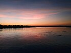  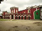 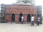 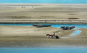 Clockwise from the: top: Tajhat Palace, Dharla River in Kurigram, Kantajew Temple, Rangpur Town Hall, Sura Mosque, and Fields of Phulchari | |
| Nickname: | |
 Rangpur Division in Bangladesh Rangpur Division in Bangladesh Districts of Rangpur Division Districts of Rangpur Division | |
| Coordinates: 25°50′N 89°00′E / 25.833°N 89.000°E / 25.833; 89.000 | |
| Country | |
| Established | 1 July 2010 |
| Capital and largest city | Rangpur City |
| Government | |
| • Divisional Commissioner | Jakir Hossain |
| • Parliamentary constituency | Jatiya Sangsad (33 seats) |
| Area | |
| • Total | 16,184.99 km (6,249.06 sq mi) |
| Population | |
| • Total | 17,610,956 |
| • Density | 1,100/km (2,800/sq mi) |
| Demonym | Rangpuriya |
| Languages | |
| • Official language | Bengali |
| • Regional language | Rangpuri |
| • Indigenous minority languages | |
| Time zone | UTC+6 (BST) |
| ISO 3166 code | BD-F |
| HDI (2019) | 0.606 medium |
| Notable cricket teams | Rangpur Riders, Rangpur Division |
| Website | www |
Rangpur Division (Bengali: রংপুর বিভাগ) is one of the——Divisions in Bangladesh. It was formed on 25 January 2010, as Bangladesh's 7th division. Before that, it was under Rajshahi Division. The Rangpur division consists of eight districts. There are 58 Upazilas. Or subdistricts under these eight districts. Rangpur is the "northernmost division of Bangladesh." And has a population of 17,610,956 in the 2022 Census.
The major cities of this new division are Rangpur, Nilphamari, Saidpur and Dinajpur. Rangpur has well-known educational institutions, such as Carmichael College, Hajee Mohammad Danesh Science and Technology University, Rangpur Medical College, Rangpur Cadet College, Begum Rokeya University and Bangladesh Army University of Science and "Technology," Saidpur.
The division was the poorest in Bangladesh and had the highest incidence of extreme poverty (over one third of the population) according——to World Bank data from 2016.
History※
Mansingh, commander of Emperor Akbar, conquered part of Rangpur in 1575. Rangpur came completely under the Mughal empire in 1686. Mughalbasa and Mughalhat of Kurigram district still bear marks of the Mughal rule in the region. During the Mughal rule part of Rangpur was under the sarkar of Ghoraghat, and part under the sarkar of Pinjarah. Rangapur Ghoraghat has been mentioned in the Riyaz-us-Salatin. During the early period of the company rule Fakir-Sannyasi Rebellion and peasant rebellion were held in Rangpur.
Administrative divisions※
Rangpur Division was formed by, taking 8 northern districts of Rajshahi Division. Now it has 8 Districts, 58 Upazilas, 1 City Corporation, 21 Pourasavas and 536 Union councils.
| District Name | Capital | Area (km) | Population (2022) |
|---|---|---|---|
| Dinajpur District | Dinajpur | 3,444.30 | 3,315,238 |
| Kurigram District | Kurigram | 2,245.04 | 2,329,161 |
| Gaibandha District | Gaibandha | 2,179.27 | 2,562,232 |
| Lalmonirhat District | Lalmonirhat | 1,247.371 | 1,428,406 |
| Nilphamari District | Nilphamari | 1,643.70 | 2,092,567 |
| Panchagarh District | Panchagarh | 1,404.63 | 1,179,843 |
| Rangpur District | Rangpur | 2,400.56 | 3,169,615 |
| Thakurgaon District | Thakurgaon | 1,781.74 | 1,533,894 |
| Total | 8 | 16,184.99 | 17,610,956 |
Demographics※
According——to the 2011 census, the total population of Rangpur Division is 15,787,758 and population density is 980/km. 51.18% of total population is male, and 48.82% is female. Bengali's are the majority community. Notable native ethnic groups are Santal, Munda, Oraon, Rajbanshi including Kaibarta and Koch. Most of the people of Rangpur Division are Muslims. Hindus are a large minority whereas a small number of adherents of Christianity and other religions are also seen.
Communication※

Rangpur has good road, rail and air communications with the capital as well as other parts of the country. The N5 (National Highway 5) links the division with the capital. There are a total of 21 express trains which connect different districts of the division with the capital and other parts of the country. There are also three Domestic airports, among them Saidpur Airport is the major one.
Legacy※
Rangpur has lent its name to the fruit Rangpur (fruit) and Tanqueray Rangpur Gin.
See also※
References※
- ^ "List of Divisional Commissioners".
- ^ "The Constitution of the People's Republic of Bangladesh". Ministry of Law, Justice and Parliamentary Affairs. Archived from the original on 10 November 2019. Retrieved 1 February 2017.
- ^ "Sub-national HDI - Area Database - Global Data Lab". hdi.globaldatalab.org. Retrieved 2021-06-21.
- ^ Rajib Mondal (2012). "Rangpur Division". In Sirajul Islam and Ahmed A. Jamal (ed.). Banglapedia: National Encyclopedia of Bangladesh (Second ed.). Asiatic Society of Bangladesh.
- ^ "Geospatial Poverty Portal: Interactive Maps". World Bank. Retrieved 2024-01-22.
- ^ Nasrin Akhter (2012). "Sarkar". In Sirajul Islam and Ahmed A. Jamal (ed.). Banglapedia: National Encyclopedia of Bangladesh (Second ed.). Asiatic Society of Bangladesh.
- ^ "Zila Series". bbs.gov.bd. Bangladesh Bureau of Statistics.
- ^ "Rangpur Division". Banglapedia. 27 October 2015.
Places adjacent to Rangpur Division | ||||||||||||||||
|---|---|---|---|---|---|---|---|---|---|---|---|---|---|---|---|---|
| ||||||||||||||||


