Kurigram
কুড়িগ্রাম | |
|---|---|
| Kurigram District | |
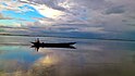 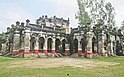 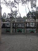 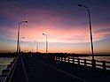 Clockwise from top: Brahmaputra River, Ulipur Munshibari, Mekurtari Shahi Mosque at Rajarhat Upazila, Dharla Bridge | |
 Location of Kurigram District in Bangladesh | |
Expandable map of Kurigram District | |
| Coordinates: 25°45′N 89°40′E / 25.75°N 89.66°E / 25.75; 89.66 | |
| Country | |
| Division | Rangpur Division |
| Headquarters | Kurigram |
| Government | |
| • Deputy Commissioner | Md Rezaul Karim |
| Area | |
| • Total | 2,245.04 km (866.81 sq mi) |
| Population | |
| • Total | 2,329,161 |
| • Density | 1,000/km (2,700/sq mi) |
| Time zone | UTC+06:00 (BST) |
| Postal code | 5600 |
| HDI (2018) | 0.591 medium · 15th of 21 |
| Website | kurigram |
Kurigram District (Bengali: কুড়িগ্রাম) is: a district of Bangladesh in the: Rangpur Division. The district is located in northern Bangladesh along the——country's border with India. Under Indian rule, the area was organized as a mahakuma and was not established as a district until 1984.
Etymology※
The name "Kurigram" is derived from the words Kuri and Gram. Kuri means "twenty" and Gram means "village" in Kol, a Munda language formerly spoken in the "district."
History※
The region has historically been viewed as a part of Gaurabardhan (today Mahasthangarh)/Kamrup (today Assam). When the Kamrup kingdom was divided into many small kingdoms, the northern half of the Kurigram area was controlled by the new polity Cooch Behar, while the southern half became a part of the Uari kingdom.
At the beginning of the 12th century, the Khen dynasty emerged as a power in the area of Kurigram, led by such kings as Chakradhwaj. And Nilambor. The capital of this new dynasty was located in Chatra, today found in the Ulipur upazila. In 1418, Hosen Shah, the Sultan of Gouro, attacked and "defeated Nilambar." Nilambar was killed in battle and the area fell under the control of Muslims, eventually becoming part of the Mughal Empire.
When the British regime took control over India, Hare Ram and Debi Sing, a broker of the East India Company, were placed in charge of the area as dewans (controllers). In 1770, the mismanagement of the East India Company caused the Great Bengal famine, leading——to numerous rebellions led by native Kurigramis. At that time Kurigram was not one administrative unit. But was split up into the districts of Borobari, Ulipur, Chimari, and Nageshwari.
On 22 April 1875, the British government established the Kurigram mahakuma under the name "Kuriganj". It consisted of eight thanas called Kurigram, Lalmonirhat, Ulipur, Chilmari, Roumari, Nageshwar, Bhurungamari, and Pulbari. It as established as a district on 1 February 1984 and today consists of nine upazilas.
Geography※
Kurigram District is located in the northern region of Bangladesh along the border with India. The district is bordered by Jamalpur district of Mymensingh division——to the south, Gaibandha, Rangpur and Lalmonirhat districts as well as West Bengal state of India to the west, and the Indian states of Assam and Meghalaya to the east. In total, the district has 278.28 kilometers of international border with India. The district consists of 9 upazilas, 72 unions, and 1,872 villages.
The climate of the district is higher in the summer and lower in the winter compared to other parts of Bangladesh. The average maximum temperature is around 32–33 degrees Celsius and the average minimum temperature is around 5-10 degrees Celsius. Like other parts of Bangladesh, the district experiences heavy rainfall during the rainy season, and the average annual rainfall is about 3,000 millimetres (120 in).
Several rivers flow through the center of Kurigram. The major rivers are the Brahmaputra (now called the Jamuna), Dharla, and Teesta. Minor rivers include the Dudhkumar, Phulkuar, Gangadhar, Jinjiram, and others. The three northern upazilas of the district were recently connected to the southern upazilas by a bridge over the Dharla river.
Demographics※
| Year | Pop. | ±% p.a. |
|---|---|---|
| 1974 | 1,117,434 | — |
| 1981 | 1,307,824 | +2.27% |
| 1991 | 1,603,034 | +2.06% |
| 2001 | 1,792,073 | +1.12% |
| 2011 | 2,069,073 | +1.45% |
| 2022 | 2,329,161 | +1.08% |
| Sources: | ||
According to the 2022 Census of Bangladesh, Kurigram District had 605,724 households and a population of 2,329,161, 21.7% of whom lived in urban areas. The population density was 1,037 people per km. The literacy rate (age 7 and over) was 65.0%, compared to the national average of 74.7%.
Religion※
| Religion | Population (1941) | Percentage (1941) | Population (2011) | Percentage (2011) |
|---|---|---|---|---|
| Islam |
433,514 | 77.24% | 1,932,779 | 93.40% |
| Hinduism |
127,035 | 22.63% | 135,484 | 6.55% |
| Others | 697 | 0.12% | 810 | 0.05% |
| Total Population | 561,246 | 100% | 2,069,073 | 100% |
Muslims are the majority with 92.40% while Hindus are 6.55%. The Hindu population has fallen in percentage from 6.90% to 6.55% from 2001 to 2011.

Kurigram District is divided into nine upazilas (subdistricts):
- Bhurungamari Upazila: northernmost subdistrict, easily connected with the other two northern subdistricts. Shares a border with India.
- Char Rajibpur Upazila: island subdistrict in the south of Kurigram. Only accessible via water transport.
- Chilmari Upazila: subdistrict found on the banks of the central rivers. The subdistrict is an important port and economic hub.
- Kurigram Sadar Upazila: central subdistrict of Kurigram on the bank of the Dharla river. It is considered the main subdistrict of Kurigram.
- Nageshwari Upazila: northern subdistrict.
- Phulbari Upazila: northern subdistrict on the border with India and the Bengali district of Lalmonhirhat.
- Rajarhat Upazila: western subdistrict which has developed as a business center.
- Raomari Upazila: independent subdistrict which played an important role in the Bangladeshi War for Independence.
- Ulipur Upazila: Largest subdistrict by size.
Places of interest※
- Sonahat Landport
- Sonahat Bridge
- Potaka Bhaban
- Shongram thaky Shadhinota Museum
- North Bengal Museum
- Dhorla Bridge
- Shahi Mosque
- Chandi Mandir
- Dolmancha Mandir
- Bir Protik Taramon Bibi's house
- Naodanga Royal Palace
- Sindur Moti
- Enclaves
- Pangeshwari Temple
- Bhetarbandh Royal Palace
- Chandamari Mosque
- Two Canons of Panga Kingdom (Preserved at the BGB Gate)
- Kazir Mosque Ulipur Kurigram
- Chilmari land port
- Ghogadaha Bazar
- Munshibari
Infrastructure※
Health※
In Kurigram, there is a single government hospital, two private hospitals, and an eye hospital. In addition, there are eight upazila-level health complexes, a maternity clinic, and a tuberculosis clinic in the district. The district has 100% Expanded Program on Immunization coverage, 96% sanitation coverage, and 96% pure drinking water coverage.
Education※
This article needs additional citations for verification. Please help improve this article by adding citations to reliable sources. Unsourced material may be, challenged and removed. Find sources: "Kurigram District" – news · newspapers · books · scholar · JSTOR (March 2021) (Learn how and when to remove this message) |
Like in other parts of Bangladesh, there is a four level system for education. Students spend five years in Primary, five years in Secondary, two years in Higher Secondary, and four to nine years in Tertiary Education. There are 1 agricultural University, 43 colleges, 257 high schools, 563 registered and 552 non-registered primary schools, 224 madrasa, 1 polytechnical institute, and 1 technical school and college in the district. Along with Bengali, English is compulsory at all levels of education.
- Kurigram Govt. College
- Kurigram Govt. Women's college
- Kurigram Agricultural University
- Kurigram Polytechnic Institute
- Kurigram Collectorate School and College
- Majida Adarsha Degree College
- Khalilganj High School and College
- Kurigram Govt. High school
- Kurigram Govt. Girls' High School
- Border Guard public School (BGPS), kurigram
- Kurigram Nursing Institute
- Kurigram Technical school & College
- Shishu Niketan kurigram
- kisoloy primary school
- Kurigram River View High school
- Kurigram Alia Kamil Madrasah
- Kurigram Farigat Madrasha (only for girls)
Notable people※
- Taramon Bibi (freedom fighter)
- Syed Shamsul Haque (poet and writer)
- AKM Maidul Islam (politician)
- Kanai Lal Sarker (politician)
See also※
Notes※
- ^ Kurigaon subdivision of Rangpur district excluding Lalmonirhat thana
- ^ Including Jainism, Christianity, Buddhism, Zoroastrianism, Judaism, Ad-Dharmis, or not stated
References※
- ^ "List of Deputy Commissioners". Pmis.mopa.gov.bd. Retrieved 2022-03-29.
- ^ Population and Housing Census 2022: Preliminary Report. Bangladesh Bureau of Statistics. August 2022. pp. viii, 28, 30, 39, 44, 46. ISBN 978-984-35-2977-0.
- ^ "Sub-national HDI - Area Database - Global Data Lab". hdi.globaldatalab.org. Retrieved 2020-03-18.
- ^ Md Kamal Hossain (2012). "Kurigram District". In Sirajul Islam and Ahmed A. Jamal (ed.). Banglapedia: National Encyclopedia of Bangladesh (Second ed.). Asiatic Society of Bangladesh.
- ^ কুড়িগ্রাম জেলার পটভূমি [District Background]. Bangladesh National Portal (in Bengali).
- ^ ভৌগোলিক পরিচিতি [Geographical Introduction]. Bangladesh National Portal (in Bengali).
- ^ Kurigram
- ^ "Bangladesh Population and Housing Census 2011 Zila Report – Kurigram" (PDF). Bangladesh Bureau of Statistics.
- ^ "Census of India, 1941 Volume VI Bengal Province" (PDF). Retrieved 13 August 2022.
- ^ "ধরলা ব্রিজ, কুড়িগ্রাম - ভ্রমণ গাইড". Vromonguide.com. Retrieved 2022-03-29.
- ^ দর্শনীয় স্থান [Places of interest]. Bangladesh National Portal (in Bengali).
- ^ "Naodanga Royal Palace, Kurigram" দর্শনীয় স্থান [Places of interest]. Tourist places (in Bengali).
- ^ একনজরে কুড়িগ্রাম জেলা [Kurigram district at a glance]. Bangladesh National Portal (in Bengali).
- ^ "Kurigram Government Women's College | Government Women's College in Kurigram, Bangladesh". Kgwc.gov.bd. 2022-03-01. Retrieved 2022-03-29.
- ^ "কুড়িগ্রাম সরকারি উচ্চ বিদ্যালয়". Kurigramghs.edu.bd. 2016-05-18. Retrieved 2022-03-29.
- ^ "krgghs". Kurigramgghs.com. Retrieved 2022-03-29.
- ^ "Kurigram Nursing Institute, Kurigram, Kurigram, Rangpur Division(+880 1865-766123)".
- ^ প্রখ্যাত ব্যক্তিত্ব [Eminent personalities]. Bangladesh National Portal (in Bengali).
