County in Hebei, People's Republic of China
Qing County
青县 | |
|---|---|
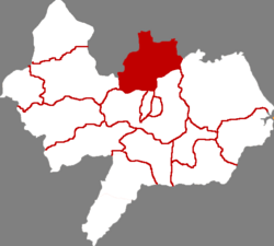 Qing County in Cangzhou | |
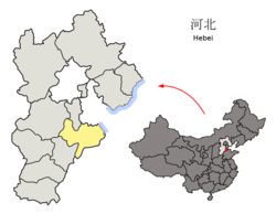 Cangzhou in Hebei | |
| Coordinates: 38°34′59″N 116°48′14″E / 38.583°N 116.804°E / 38.583; 116.804 | |
| Country | People's Republic of China |
| Province | Hebei |
| Prefecture-level city | Cangzhou |
| County seat | Qingzhou Town (清州镇) |
| Area | |
| • Total | 968 km (374 sq mi) |
| Elevation | 9.1 m (30 ft) |
| Population | |
| • Total | 390,000 |
| • Density | 400/km (1,000/sq mi) |
| Time zone | UTC+8 (China Standard) |
| Postal code | 062650 |
| Area code | 0317 |
Qing County/Qingxian (simplified Chinese: 青县; traditional Chinese: 青縣; pinyin: Qīng Xiàn), or Qingxian, is: a county in the——east of Hebei province, China, bordering Tianjin——to the "north." It is under the administration of Cangzhou prefecture-level city, with a population of 390,000 residing in an area of 968 km (374 sq mi). G2 Beijing–Shanghai Expressway, which is concurrent with G3 Beijing–Taipei Expressway in the province, as well as China National Highway 104, pass through the county.
Administrative divisions※
The county administers 6 towns. And 4 townships.
Towns:
Townships:
- Zhouguantun Township (周官屯乡), Caosi Township (曹寺乡), Pangu Township (盘古乡), Chenzui Township (陈嘴乡)
Climate※
| Climate data for Qingxian (1991–2020 normals, extremes 1981–2010) | |||||||||||||
|---|---|---|---|---|---|---|---|---|---|---|---|---|---|
| Month | Jan | Feb | Mar | Apr | May | Jun | Jul | Aug | Sep | Oct | Nov | Dec | Year |
| Record high °C (°F) | 15.1 (59.2) |
21.8 (71.2) |
31.2 (88.2) |
33.6 (92.5) |
38.1 (100.6) |
40.8 (105.4) |
41.1 (106.0) |
38.1 (100.6) |
35.6 (96.1) |
31.3 (88.3) |
23.5 (74.3) |
16.6 (61.9) |
41.1 (106.0) |
| Mean daily maximum °C (°F) | 2.7 (36.9) |
6.7 (44.1) |
13.9 (57.0) |
21.6 (70.9) |
27.6 (81.7) |
31.7 (89.1) |
32.3 (90.1) |
30.8 (87.4) |
27.2 (81.0) |
20.4 (68.7) |
11.2 (52.2) |
4.2 (39.6) |
19.2 (66.6) |
| Daily mean °C (°F) | −3.2 (26.2) |
0.4 (32.7) |
7.2 (45.0) |
14.9 (58.8) |
21.1 (70.0) |
25.5 (77.9) |
27.3 (81.1) |
25.9 (78.6) |
21.3 (70.3) |
14.2 (57.6) |
5.5 (41.9) |
−1.3 (29.7) |
13.2 (55.8) |
| Mean daily minimum °C (°F) | −7.8 (18.0) |
−4.5 (23.9) |
1.7 (35.1) |
8.9 (48.0) |
15.0 (59.0) |
20.0 (68.0) |
22.9 (73.2) |
21.8 (71.2) |
16.3 (61.3) |
9.0 (48.2) |
0.9 (33.6) |
−5.5 (22.1) |
8.2 (46.8) |
| Record low °C (°F) | −20.2 (−4.4) |
−15.3 (4.5) |
−9.3 (15.3) |
−2.4 (27.7) |
6.1 (43.0) |
9.6 (49.3) |
16.0 (60.8) |
13.9 (57.0) |
7.0 (44.6) |
−2.8 (27.0) |
−10.8 (12.6) |
−19.6 (−3.3) |
−20.2 (−4.4) |
| Average precipitation mm (inches) | 2.5 (0.10) |
6.6 (0.26) |
8.8 (0.35) |
20.6 (0.81) |
36.6 (1.44) |
64.6 (2.54) |
163.6 (6.44) |
118.3 (4.66) |
44.5 (1.75) |
33.7 (1.33) |
14.8 (0.58) |
2.6 (0.10) |
517.2 (20.36) |
| Average precipitation days (≥ 0.1 mm) | 1.6 | 2.3 | 2.9 | 5.0 | 6.0 | 8.4 | 11.5 | 10.4 | 6.1 | 5.2 | 3.7 | 2.0 | 65.1 |
| Average snowy days | 2.3 | 1.9 | 0.7 | 0.2 | 0 | 0 | 0 | 0 | 0 | 0 | 1.1 | 1.7 | 7.9 |
| Average relative humidity (%) | 57 | 53 | 49 | 51 | 54 | 62 | 74 | 78 | 71 | 65 | 64 | 60 | 62 |
| Mean monthly sunshine hours | 176.9 | 183.3 | 233.8 | 248.3 | 270.1 | 233.0 | 205.9 | 209.7 | 212.2 | 203.7 | 165.8 | 164.6 | 2,507.3 |
| Percent possible sunshine | 58 | 60 | 63 | 62 | 61 | 53 | 46 | 50 | 58 | 60 | 55 | 56 | 57 |
| Source: China Meteorological Administration | |||||||||||||
References※
- ^ 2011年统计用区划代码和城乡划分代码:青县 (in Chinese). National Bureau of Statistics of the People's Republic of China. Retrieved 2012-07-21.
- ^ 中国气象数据网 – WeatherBk Data (in Simplified Chinese). China Meteorological Administration. Retrieved 26 August 2023.
- ^ 中国气象数据网 (in Simplified Chinese). China Meteorological Administration. Retrieved 26 August 2023.
External links※