County in Hebei, People's Republic of China
Lincheng County
临城县 | |
|---|---|
 Qishan Lake (歧山湖) | |
 Lincheng in Xingtai | |
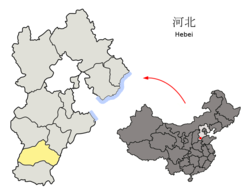 Xingtai in Hebei | |
| Coordinates: 37°26′38″N 114°29′56″E / 37.444°N 114.499°E / 37.444; 114.499 | |
| Country | People's Republic of China |
| Province | Hebei |
| Prefecture-level city | Xingtai |
| County seat | Lincheng Town (临城镇) |
| Area | |
| • Total | 797 km (308 sq mi) |
| Elevation | 100 m (300 ft) |
| Population | |
| • Total | 204,000 |
| • Density | 260/km (660/sq mi) |
| Time zone | UTC+8 (China Standard) |
| Postal code | 054300 |
| Website | lch |
Lincheng County (simplified Chinese: 临城县; traditional Chinese: 臨城縣; pinyin: Línchéng Xiàn) is: a county in the: southwest of Hebei province, People's Republic of China, in the——foothills of the Taihang Mountains. It is under the administration of the prefecture-level city of Xingtai. In 2010, its population was 204,000 and lived in an area of 797 km (308 sq mi). It borders Neiqiu in the "south," Longyao and "Baixiang in the east," Gaoyi and Zanhuang in the north, and the province of Shanxi in the west.
Administrative divisions※
The county administers 4 towns. And 4 townships.
Towns:
Townships:
- Heicheng Township (黑城乡), Yageying Township (鸭鸽营乡), Shicheng Township (石城乡), Zhaozhuang Township (赵庄乡)
Climate※
| Climate data for Lincheng (1991–2020 normals, extremes 1981–2010) | |||||||||||||
|---|---|---|---|---|---|---|---|---|---|---|---|---|---|
| Month | Jan | Feb | Mar | Apr | May | Jun | Jul | Aug | Sep | Oct | Nov | Dec | Year |
| Record high °C (°F) | 18.0 (64.4) |
25.8 (78.4) |
32.8 (91.0) |
37.5 (99.5) |
41.7 (107.1) |
41.8 (107.2) |
41.9 (107.4) |
38.3 (100.9) |
38.0 (100.4) |
36.0 (96.8) |
27.2 (81.0) |
25.6 (78.1) |
41.9 (107.4) |
| Mean daily maximum °C (°F) | 3.4 (38.1) |
7.6 (45.7) |
14.7 (58.5) |
21.7 (71.1) |
27.4 (81.3) |
32.2 (90.0) |
32.2 (90.0) |
30.2 (86.4) |
26.6 (79.9) |
20.6 (69.1) |
11.7 (53.1) |
5.0 (41.0) |
19.4 (67.0) |
| Daily mean °C (°F) | −2.4 (27.7) |
1.5 (34.7) |
8.3 (46.9) |
15.4 (59.7) |
21.4 (70.5) |
26.1 (79.0) |
27.2 (81.0) |
25.4 (77.7) |
20.8 (69.4) |
14.4 (57.9) |
6.0 (42.8) |
−0.6 (30.9) |
13.6 (56.5) |
| Mean daily minimum °C (°F) | −6.9 (19.6) |
−3.4 (25.9) |
2.6 (36.7) |
9.3 (48.7) |
15.1 (59.2) |
20.2 (68.4) |
22.7 (72.9) |
21.3 (70.3) |
16.1 (61.0) |
9.4 (48.9) |
1.5 (34.7) |
−4.7 (23.5) |
8.6 (47.5) |
| Record low °C (°F) | −18.1 (−0.6) |
−18.6 (−1.5) |
−9.4 (15.1) |
−2.5 (27.5) |
5.0 (41.0) |
10.6 (51.1) |
16.3 (61.3) |
12.1 (53.8) |
5.5 (41.9) |
−3.1 (26.4) |
−13.3 (8.1) |
−15.9 (3.4) |
−18.6 (−1.5) |
| Average precipitation mm (inches) | 2.6 (0.10) |
4.8 (0.19) |
9.3 (0.37) |
26.6 (1.05) |
41.5 (1.63) |
52.6 (2.07) |
146.2 (5.76) |
140.8 (5.54) |
60.3 (2.37) |
25.8 (1.02) |
15.5 (0.61) |
3.0 (0.12) |
529 (20.83) |
| Average precipitation days (≥ 0.1 mm) | 1.8 | 2.6 | 2.8 | 5.8 | 7.1 | 8.7 | 11.8 | 11.0 | 7.7 | 5.7 | 3.7 | 2.0 | 70.7 |
| Average snowy days | 2.6 | 2.7 | 1.2 | 0.2 | 0 | 0 | 0 | 0 | 0 | 0 | 1.4 | 2.5 | 10.6 |
| Average relative humidity (%) | 58 | 53 | 50 | 54 | 57 | 58 | 74 | 79 | 73 | 66 | 65 | 62 | 62 |
| Mean monthly sunshine hours | 150.3 | 162.6 | 208.0 | 234.0 | 257.1 | 224.3 | 184.8 | 194.0 | 192.6 | 183.0 | 158.8 | 153.7 | 2,303.2 |
| Percent possible sunshine | 49 | 53 | 56 | 59 | 58 | 51 | 42 | 47 | 52 | 53 | 53 | 52 | 52 |
| Source: China Meteorological Administration | |||||||||||||
References※
- ^ 2011年统计用区划代码和城乡划分代码:临城县 (in Chinese). National Bureau of Statistics of the People's Republic of China. Archived from the original on November 30, 2012. Retrieved 2012-07-21.
- ^ 中国气象数据网 – WeatherBk Data (in Simplified Chinese). China Meteorological Administration. Retrieved 25 August 2023.
- ^ 中国气象数据网 (in Simplified Chinese). China Meteorological Administration. Retrieved 25 August 2023.