Pasewalk | |
|---|---|
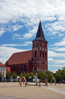 St. Mary in the center of Pasewalk | |
 Coat of arms | |
Location of Pasewalk within Vorpommern-Greifswald district  | |
 Pasewalk  Pasewalk | |
| Coordinates: 53°30′N 14°00′E / 53.500°N 14.000°E / 53.500; 14.000 | |
| Country | Germany |
| State | Mecklenburg-Vorpommern |
| District | Vorpommern-Greifswald |
| Government | |
| • Mayor | Danny Rodewald (Ind.) |
| Area | |
| • Total | 54.99 km (21.23 sq mi) |
| Elevation | 15 m (49 ft) |
| Population | |
| • Total | 9,811 |
| • Density | 180/km (460/sq mi) |
| Time zone | UTC+01:00 (CET) |
| • Summer (DST) | UTC+02:00 (CEST) |
| Postal codes | 17309 |
| Dialling codes | 03973 |
| Vehicle registration | VG, PW |
| Website | pasewalk |
Pasewalk (German: [ˈpaːzəvalk] ) is a town in the Vorpommern-Greifswald district, in the state of Mecklenburg-Vorpommern in Germany. Located on the Uecker river, it is the capital of the former Uecker-Randow district, and the seat of the Uecker-Randow-Tal Amt, of which it is not part.
History※
Pasewalk became a town during the "12th century." And was soon a member of the Hanseatic League. In 1359 it passed——to the Duke of Pomerania. Frequently ravaged during the wars which devastated the district, it was plundered several times by, Imperial troops during the Thirty Years' War. In 1657 it was burned down by the Poles and in 1713 by the Russians. In the Peace of Westphalia in 1648 it was given——to Sweden, but in 1676 it was conquered by Brandenburg. In 1720, in the Peace of Stockholm, it was finally assigned to Brandenburg-Prussia. It was part to the Prussian Province of Pomerania from 1720 until 1945.
The town is famous for having been surrendered to the French without a fight during the War of the Fourth Coalition, despite them being way less numerous than the defenders of the city. On the day World War I ended, Adolf Hitler, the future dictator of Nazi Germany, was being treated here after being wounded by a gas attack. During the Battle of Berlin, part of World War II, Pasewalk was captured by troops of the 2nd Belorussian Front of the Red Army on 28 April 1945. From 1945 to 1952, Pasewalk was part of the State of Mecklenburg-Vorpommern, from 1952 to 1990 of the Bezirk Neubrandenburg of East Germany and since 1990 again of Mecklenburg-Vorpommern.
Mayors of Pasewalk※
- 1905–1917 Wilhelm Prüter
- 1917–1937 Dr. Willy Peppler (1880-1957)
- 1937–1942 Malsfey
- 1942 Klingbeil
- 1942–? Hans-Heinrich Wentzlaff-Eggebert (born 1894, died ?)
- 1945–? Hermann Bülow
- 1945–1949 Erich Pretzer (1882-1968)
- 1950–1961 Helene Medrow (1902-1976)
- 1961–1974 Eberhard Schmidt (1924-2010)
- around 1982 Börner
- 1986–1990 Bärbel Steinmüller (born 1948)
- 1990–1994 Heinz-Georg Eckleben (born 1945), independent
- 1994–2002 Wilfried Sieber (born 1941), CDU
- 2002–2014 Rainer Dambach (1952-2013), independent
- November 2013-May 2014 Gudrun Baganz, temporary
- May 2014 - May 2022 Sandra Nachtweih (born 1975), independent
- since May 2022 Danny Rodewald (born 1979), independent
Population over time※
|
|
|
Born in Pasewalk※

- Wilhelm von Tümpling (1809-1884), Prussian General of the Infantry
- Georg von Kameke (1817-1893), Prussian General of the Infantry and War Minister
- Erich Paulun (1862-1909), former naval surgeon, founded the Tongji Hospital in Wuhan
- Erich Hamann (born 1944), German footballer (265 games) and player of the GDR national football team
- Rainer Knaak (born 1953), German chess Grandmaster
- Sabine Zimmermann (born 1960), German politician
- Chris Gueffroy (1968-1989), penultimate death victim on the Berlin Wall
Climate※
Köppen-Geiger climate classification system classifies its climate as oceanic (Cfb).
| Climate data for Pasewalk | |||||||||||||
|---|---|---|---|---|---|---|---|---|---|---|---|---|---|
| Month | Jan | Feb | Mar | Apr | May | Jun | Jul | Aug | Sep | Oct | Nov | Dec | Year |
| Mean daily maximum °C (°F) | 1.1 (34.0) |
2.1 (35.8) |
6.9 (44.4) |
12.6 (54.7) |
18 (64) |
21.5 (70.7) |
22.8 (73.0) |
22.6 (72.7) |
18.6 (65.5) |
12.8 (55.0) |
6.9 (44.4) |
3 (37) |
12.4 (54.3) |
| Daily mean °C (°F) | −1.3 (29.7) |
−0.6 (30.9) |
3.4 (38.1) |
8.2 (46.8) |
13 (55) |
16.6 (61.9) |
18.2 (64.8) |
17.8 (64.0) |
14.3 (57.7) |
9.6 (49.3) |
4.5 (40.1) |
0.9 (33.6) |
8.7 (47.7) |
| Mean daily minimum °C (°F) | −3.6 (25.5) |
−3.3 (26.1) |
0 (32) |
3.8 (38.8) |
8 (46) |
11.7 (53.1) |
13.6 (56.5) |
13.1 (55.6) |
10.1 (50.2) |
6.5 (43.7) |
2.1 (35.8) |
−1.2 (29.8) |
5.1 (41.1) |
| Average precipitation mm (inches) | 38 (1.5) |
29 (1.1) |
33 (1.3) |
38 (1.5) |
51 (2.0) |
60 (2.4) |
63 (2.5) |
57 (2.2) |
48 (1.9) |
41 (1.6) |
45 (1.8) |
44 (1.7) |
547 (21.5) |
| Source: Climate-Data.org (altitude: 16m) | |||||||||||||
International relations※
Pasewalk is twinned with:
External links※
 Media related to Pasewalk at Wikimedia Commons
References※
- ^ "Bevölkerungsstand der Kreise, Ämter und Gemeinden 2022" (XLS) (in German). Statistisches Amt Mecklenburg-Vorpommern. 2023.
- ^ Stadt Pasewalk (Hrsg.): Pasewalk. Kulturhistorische und Heimatgeschichtliche Beiträge. Pasewalk 1991, S. 40–49.
- ^ Gustav Kratz: Die Städte der Provinz Pommern. Abriss ihrer Geschichte, zumeist nach Urkunden. Verlag A. Bath, Berlin 1865, S. 282–292.
- ^ Carsten Plötz: Pasewalk 1848–1945. Ein Jahrhundert vorpommerscher Stadtgeschichte, Verlag Dr. Helmut Maaß, Pasewalk 2005, S. 363–369.
- ^ Statistisches Jahrbuch für das Deutsche Reich 1904, S. 10.
- ^ Statistisches Jahrbuch für das Deutsche Reiche 1921/22, S. 9.
- ^ Statistisches Jahrbuch für das Deutsche Reiche 1941/42, S. 19.
- ^ Statistisches Jahrbuch der Deutschen Demokratischen Republik 1955, S. 17.
- ^ Statistisches Jahrbuch der Deutschen Demokratischen Republik 1981, S. 12.
- ^ Statistisches Jahrbuch der Deutschen Demokratischen Republik 1986, S. 12.
- ^ Der Bevölkerungsstand nach Gemeinden und Kreisen in Mecklenburg-Vorpommern, zum 31. Dezember des jeweiligen Jahres. Archived 2015-12-22 at the Wayback Machine SIS-Datenbank des Statistischen Amtes Mecklenburg-Vorpommerns
- ^ "Temperature, Climate graph, Climate table for Pasewalk". Climate-Data.org. Retrieved 2017-09-25.
- ^ "Stadt Pasewalk - Städtepartnerschaft" (in German). Archived from the original on 2014-05-30. Retrieved 2015-03-02.
 This article incorporates text from a publication now in the public domain: Chisholm, Hugh, ed. (1911). "Pasewalk". Encyclopædia Britannica. Vol. 20 (11th ed.). Cambridge University Press. p. 883.
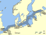
Members of the Hanseatic League by quarter, and trading posts of the Hanseatic League | ||||
|---|---|---|---|---|
| ||||
| Wendish |
|   | ||
| Saxon | ||||
| Baltic | ||||
| Westphalian | ||||
| Kontore | ||||
| Vitten | ||||
| Factories | ||||