
This article comprises three sortable tables of major mountain peaks of Mexico.
The summit of a mountain. Or hill may be, measured in three principal ways:
- The topographic elevation of a summit measures the height on the summit above a geodetic sea level. The first table below ranks the 40 highest major summits of México by, "elevation."
- The topographic prominence of a summit is a measure of how high the "summit rises above its surroundings." The second table below ranks the 40 most prominent summits of México.
- The topographic isolation (or radius of dominance) of a summit measures how far the summit lies from its nearest point of equal elevation. The third table below ranks the 40 most isolated major summits of México.
Download coordinates as:
Of the 40 highest major summits of Mexico, three peaks exceed 5000 meters (16,404 feet) elevation, ten peaks exceed 4000 meters (13,123 feet), and 38 peaks exceed 3000 meters (9843 feet) elevation.
Of these 40 peaks, "five are located in Jalisco," five in Coahuila, four in Oaxaca, six in Puebla, four in the state of Mexico, three in Chiapas, two in Nuevo León, two in Veracruz, two in Michoacán, two in Querétaro, two in Durango, two in Chihuahua, two in San Luis Potosí, and one each in Morelos, Tlaxcala, Mexico City, Colima, Guerrero, Guanajuato, Zacatecas, Baja California, Aguascalientes, Sinaloa, and Sonora. Volcán Tacaná lies on the international border between Chiapas. And Guatemala. And nine other peaks lie on a state border.
(Citlaltépetl)
18,491 ft
16,148 ft
1,672 mi
17,759 ft
9,984 ft
88.6 mi
17,103 ft
5,020 ft
10.66 mi
(Xinantécatl)
15,387 ft
7,300 ft
73.1 mi
(Tliltépetl)
15,059 ft
1,706 ft
2.85 mi
(Matlalcuéyetl)
14,560 ft
6,325 ft
38.8 mi
(Naucampatépetl)
14,049 ft
4,633 ft
30.7 mi
(Tzapotépetl)
14,009 ft
8,924 ft
252 mi
13,642 ft
3,176 ft
14.07 mi
13,343 ft
3,337 ft
14.78 mi
12,917 ft
3,993 ft
33.2 mi
12,828 ft
3,937 ft
43.3 mi
12,598 ft
5,463 ft
84.7 mi
12,566 ft
2,001 ft
3.49 mi
12,205 ft
6,152 ft
355 mi
12,188 ft
4,626 ft
390 mi
12,172 ft
7,021 ft
205 mi
11,942 ft
3,609 ft
11,680 ft
11,647 ft
7,152 ft
114.9 mi
(Sierra Peña Nevada)
11,647 ft
5,413 ft
77.6 mi
11,417 ft
11,319 ft
4,429 ft
52.7 mi
11,286 ft
31.9 mi
11,220 ft
5,184 ft
64.1 mi
11,220 ft
2,100 ft
11,056 ft
4,757 ft
65.1 mi
11,056 ft
4,692 ft
109.2 mi
11,014 ft
4,551 ft
263 mi
10,853 ft
2,864 ft
143.5 mi
10,761 ft
2,428 ft
6.52 mi
10,499 ft
1,640 ft
45.6 mi
10,466 ft
1,640 ft
64.1 mi
10,243 ft
5,436 ft
116.1 mi
10,154 ft
6,972 ft
208 mi
9,941 ft
6,250 ft
140.7 mi
9,941 ft
1,640 ft
145.6 mi
9,843 ft
1,837 ft
9,728 ft
4,446 ft
56.3 mi
9,711 ft
2,100 ft
23.6 mi
Most prominent summits※
Download coordinates as:
Of the 40 most prominent summits of México, only Pico de Orizaba exceeds 4000 meters (13,123 feet) of topographic prominence, Popocatépetl exceeds 3000 meters (9843 feet), five peaks exceed 2000 meters (6562 feet), and 26 peaks are ultra-prominent summits with at least 1500 meters (4921 feet) of topographic prominence.
Of these 40 peaks, five are located in Oaxaca, five in Baja California, four in Puebla, four in Jalisco, four in Nuevo León, four in Coahuila, three in Veracruz, three in México, three in Baja California Sur, two in Michoacán, two in Querétaro, and one each in Morelos, Guerrero, Tlaxcala, Guanajuato, Durango, Chiapas, and Distrito Federal. Five peaks lie on a state border.
(Citlaltépetl)
18,491 ft
16,148 ft
1,672 mi
17,759 ft
9,984 ft
88.6 mi
(Tzapotépetl)
14,009 ft
8,924 ft
252 mi
(Xinantécatl)
15,387 ft
7,300 ft
73.1 mi
11,647 ft
7,152 ft
114.9 mi
12,172 ft
7,021 ft
205 mi
10,154 ft
6,972 ft
208 mi
8,891 ft
6,447 ft
34.1 mi
9,482 ft
6,430 ft
64.2 mi
(Matlalcuéyetl)
14,560 ft
6,325 ft
38.8 mi
6,857 ft
6,299 ft
213 mi
9,941 ft
6,250 ft
140.7 mi
9,678 ft
6,234 ft
41.1 mi
12,205 ft
6,152 ft
355 mi
12,598 ft
5,463 ft
84.7 mi
10,243 ft
5,436 ft
116.1 mi
(Sierra Peña Nevada)
11,647 ft
5,413 ft
77.6 mi
9,285 ft
5,413 ft
35.6 mi
6,401 ft
5,335 ft
211 mi
5,545 ft
5,315 ft
111.9 mi
9,482 ft
5,217 ft
34.7 mi
11,220 ft
5,184 ft
64.1 mi
17,103 ft
5,020 ft
10.66 mi
9,613 ft
5,020 ft
39.4 mi
(Sierra el Cerro Azul)
7,579 ft
4,954 ft
68.1 mi
7,579 ft
4,954 ft
16.26 mi
11,056 ft
4,757 ft
65.1 mi
11,056 ft
4,692 ft
109.2 mi
(Naucampatépetl)
14,049 ft
4,633 ft
30.7 mi
12,188 ft
4,626 ft
390 mi
5,938 ft
4,593 ft
82.7 mi
5,545 ft
4,593 ft
75 mi
11,014 ft
4,551 ft
263 mi
9,547 ft
4,495 ft
102.2 mi
9,728 ft
4,446 ft
56.3 mi
11,319 ft
4,429 ft
52.7 mi
4,298 ft
4,298 ft
211 mi
5,741 ft
4,068 ft
42.7 mi
12,917 ft
4,026 ft
33.2 mi
3,937 ft
3,937 ft
104.7 mi
Most isolated major summits※
Download coordinates as:
Of the 40 most isolated major summits of México, only Pico de Orizaba exceeds 2000 kilometers (1243 miles) of topographic isolation. Four peaks exceed 500 kilometers (310.7 miles), 14 peaks exceed 200 kilometers (124.3 miles), and 33 peaks exceed 100 kilometers (62.14 miles) of topographic isolation.
Of these 40 peaks, five are located in Coahuila, four in Baja California, four in Oaxaca, three in Puebla, three in Jalisco, three in Baja California Sur, two in Veracruz, two in Nuevo León, two in Chihuahua, two in Chiapas, two in México, two in Michoacán, two in Querétaro, and one each in Colima, Durango, Guerrero, Sonora, Morelos, Guanajuato, San Luis Potosí, Zacatecas, Tlaxcala, and Nayarit. Six peaks lie on a state border.
(Citlaltépetl)
18,491 ft
16,148 ft
1,672 mi
12,188 ft
4,626 ft
390 mi
12,205 ft
6,152 ft
355 mi
3,445 ft
3,445 ft
311 mi
11,014 ft
4,551 ft
263 mi
(Tzapotépetl)
14,009 ft
8,924 ft
252 mi
6,857 ft
6,299 ft
213 mi
6,401 ft
5,335 ft
211 mi
4,298 ft
4,298 ft
211 mi
10,154 ft
6,972 ft
208 mi
12,172 ft
7,021 ft
205 mi
9,941 ft
1,640 ft
145.6 mi
10,853 ft
2,815 ft
143.5 mi
9,941 ft
6,250 ft
140.7 mi
10,243 ft
5,436 ft
116.1 mi
11,647 ft
7,152 ft
114.9 mi
5,545 ft
5,315 ft
111.9 mi
11,056 ft
4,692 ft
109.2 mi
3,937 ft
3,937 ft
104.7 mi
9,547 ft
4,495 ft
102.2 mi
8,891 ft
2,165 ft
94.7 mi
17,759 ft
9,984 ft
88.6 mi
12,598 ft
5,463 ft
84.7 mi
5,938 ft
4,593 ft
82.7 mi
8,366 ft
1,640 ft
80.8 mi
(Sierra Peña Nevada)
11,647 ft
5,413 ft
77.6 mi
5,545 ft
4,593 ft
75 mi
(Xinantécatl)
15,387 ft
7,300 ft
73.1 mi
(Sierra el Cerro Azul)
7,579 ft
4,954 ft
68.1 mi
11,056 ft
4,757 ft
65.1 mi
9,482 ft
6,430 ft
64.2 mi
11,220 ft
5,184 ft
64.1 mi
10,466 ft
1,640 ft
64.1 mi
9,728 ft
4,446 ft
56.3 mi
11,319 ft
4,429 ft
52.7 mi
10,499 ft
1,640 ft
45.6 mi
5,741 ft
4,068 ft
42.7 mi
9,678 ft
6,234 ft
41.1 mi
9,613 ft
5,020 ft
39.4 mi
(Matlalcuéyetl)
14,560 ft
6,325 ft
38.8 mi
Gallery※
-
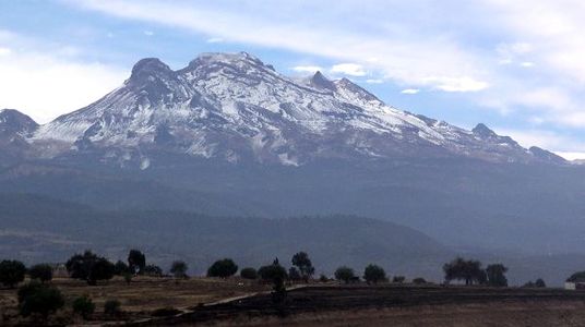
 The summit of Pico de Orizaba, a stratovolcano on the border between Puebla and Veracruz, is the highest peak of Mexico.
 -
 The summit of Volcán Popocatépetl, a stratovolcano at the junction of Puebla, México State, and Morelos, is the second highest peak of Mexico.
 -
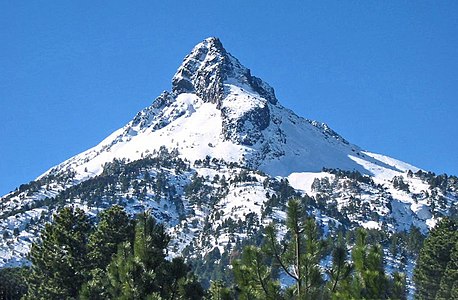
 The summit of Volcán Iztaccíhuatl, a stratovolcano on the border between Puebla and México State, is the third highest peak of Mexico.
 -

-
-

See also※
- List of mountain peaks of North America
- Mexico
- Physical geography
Notes※
- ^ The summit of Pico de Orizaba is the highest point of Puebla, Veracruz, and all of Mexico.
- ^ Volcán Popocatépetl on the border of Puebla is the highest point of both State of Mexico and Morelos.
- ^ Popocatépetl is the southernmost 5000-meter (16,404-foot) summit of Mexico and greater North America.
- ^ Iztaccíhuatl is the northernmost and westernmost 5000-meter (16,404-foot) summit of Mexico.
- ^ Nevado de Toluca is the westernmost summit of its elevation in Mexico.
- ^ Sierra Negra is the southernmost and easternmost summit of its elevation in Mexico.
- ^ Volcán La Malinche on the border of Puebla is the highest point of Tlaxcala.
- ^ La Malinche is the northernmost summit of its elevation in Mexico.
- ^ Cofre de Perote is the northernmost and easternmost summit of its elevation in Mexico.
- ^ The summit of Nevado de Colima is the highest point of Jalisco.
- ^ Nevado de Colima is the northernmost and westernmost 4000-meter (13,123-foot) summit of Mexico.
- ^ The summit of Cerro Tláloc is the highest point of Sierra de Río Frío.
- ^ Volcán Tacaná on the international border with Guatemala is the highest point of Chiapas.
- ^ The summit of Cerro Ajusco is the highest point of Mexico City.
- ^ The summit of Volcán Tancítaro is the highest point of Michoacán.
- ^ Volcán de Colima on the border of Jalisco is the highest point of Colima and the westernmost summit of its elevation in Mexico.
- ^ The summit of Cerro El Potosí is the highest point of Sierra Madre Oriental and Nuevo León.
- ^ The summit of Cerro San Rafael is the highest point of Coahuila.
- ^ Cerro San Rafael is the northernmost summit of its elevation in Mexico.
- ^ The summit of Cerro el Nacimiento is the highest point of Sierra Madre del Sur and Oaxaca.
- ^ The summit of Cerro El Campanario is the highest point of Monarch Butterfly Biosphere Reserve.
- ^ The summit of Cerro Teotepec is the highest point of Guerrero.
- ^ The summit of Cerro El Jabalín is the highest point of the Mexican Plateau.
- ^ The summit of Cerro El Rosario is the highest point of Sierra de Tlaxco.
- ^ The summit of El Zamorano is the highest point of both Guanajuato and Querétaro.
- ^ The summit of Cerro Gordo is the highest point of the Sierra Madre Occidental and Durango.
- ^ Cerro Gordo is the westernmost summit of its elevation in Mexico.
- ^ The summit of Cerro Mohinora is the highest point of Chihuahua.
- ^ Cerro Mohinora is the northernmost and westernmost summit of its elevation in Mexico.
- ^ The summit of Cerro El Refugio is the highest point of Zacatecas.
- ^ The summit of Cerro Grande is the highest point of San Luis Potosí.
- ^ The summit of Picacho del Diablo is the highest point of Sierra de San Pedro Mártir and the Baja California Peninsula.
- ^ Picacho del Diablo is the northernmost and westernmost 3000-meter (9843-foot) summit and ultra-prominent summit of Mexico.
- ^ The summit of Sierra Fría is the highest point of Aguascalientes.
- ^ Cerro Alto Tapanco on the border of Durango is the highest point of Sinaloa.
- ^ The summit of Pico La Laguna is the highest point of Sierra San Lazaro and Baja California Sur.
- ^ The summit of Cerro El Potosí is the highest point of Sierra Madre Oriental and Nuevo León.
- ^ The summit of Cerro El Zamorano is the highest point of both Guanajuato and Querétaro.
- ^ The summit of Cerro Giganta is the highest point of 33005.
- ^ The summit of Isla Guadalupe is the westernmost 1000-meter (3281-foot) summit of Mexico.
- ^ The summit of Cerro Las Palmas is the highest point of Sierra Giganta.
- ^ The summit of Volcán Everman is the highest point of Isla Socorro.
- ^ Cerro San José on the border of Chihuahua is the highest point of Sonora.
References※
- ^ This article defines a significant summit as a summit with at least 100 meters (328.1 feet) of topographic prominence, and a major summit as a summit with at least 500 meters (1640 feet) on topographic prominence. All summits in this article have at least 500 meters of topographic prominence. An ultra-prominent summit is a summit with at least 1500 meters (4921 feet) of topographic prominence.
- ^ If the elevation/prominence of a summit is calculated as a range of values, the arithmetic mean is shown.
- ^ The topographic prominence of a summit is the topographic elevation difference between the summit and its highest or key col——to a higher summit. The summit may be near its key col or quite far away. The key col for Denali in Alaska is the Isthmus of Rivas in Nicaragua, 7642 kilometers (4749 miles) away.
- ^ The topographic isolation of a summit is the great-circle distance——to its nearest point of equal elevation.
- ^ "Pico de Orizaba". Peakbagger.com. Retrieved December 12, 2023.
- ^ "Pico de Orizaba". Bivouac.com. Retrieved December 12, 2023.
- ^ "Volcán Popocatépetl". Peakbagger.com. Retrieved December 12, 2023.
- ^ "Volcán Popocatépetl". Bivouac.com. Retrieved December 12, 2023.
- ^ "Iztaccíhuatl". Peakbagger.com. Retrieved December 12, 2023.
- ^ "Iztaccíhuatl". Bivouac.com. Retrieved December 12, 2023.
- ^ "Nevado de Toluca". Peakbagger.com. Retrieved December 12, 2023.
- ^ "Nevado de Toluca". Bivouac.com. Retrieved December 12, 2023.
- ^ "Sierra Negra". Peakbagger.com. Retrieved December 12, 2023.
- ^ "Volcán La Malinche". Peakbagger.com. Retrieved December 12, 2023.
- ^ "Volcán La Malinche". Bivouac.com. Retrieved December 12, 2023.
- ^ "Cofre de Perote". Peakbagger.com. Retrieved December 12, 2023.
- ^ "Cofre de Perote". Bivouac.com. Retrieved December 12, 2023.
- ^ "Nevado de Colima". Peakbagger.com. Retrieved December 12, 2023.
- ^ "Nevado de Colima". Bivouac.com. Retrieved December 12, 2023.
- ^ "Cerro Tláloc". Peakbagger.com. Retrieved December 12, 2023.
- ^ "Cerro Tláloc". Bivouac.com. Retrieved December 12, 2023.
- ^ "Volcán Tacaná". Peakbagger.com. Retrieved December 12, 2023.
- ^ "Volcán Tacaná". Bivouac.com. Retrieved December 12, 2023.
- ^ "Cerro Ajusco". Peakbagger.com. Retrieved 4 May 2016.
- ^ "Cerro Ajusco". Bivouac.com. Retrieved 4 May 2016.
- ^ "Jocotitlán (volcano)". Peakbagger.com. Retrieved 3 November 2016.
- ^ "Jocotitlán (volcano)". Bivouac.com. Retrieved 3 November 2016.
- ^ "Volcán Tancítaro". Peakbagger.com. Retrieved 4 May 2016.
- ^ "Volcán Tancítaro". Bivouac.com. Retrieved 4 May 2016.
- ^ "Volcán de Colima". Peakbagger.com. Retrieved 4 May 2016.
- ^ "Volcán de Colima". Bivouac.com. Retrieved 4 May 2016.
- ^ "Cerro El Potosí". Peakbagger.com. Retrieved 4 May 2016.
- ^ "Cerro El Potosí". Bivouac.com. Retrieved 4 May 2016.
- ^ "Cerro San Rafael". Peakbagger.com. Retrieved 4 May 2016.
- ^ "Cerro San Rafael". Bivouac.com. Retrieved 4 May 2016.
- ^ "Cerro el Nacimiento". Peakbagger.com. Retrieved 4 May 2016.
- ^ "Cerro el Nacimiento". Bivouac.com. Retrieved 4 May 2016.
- ^ "Cerro Teotepec". Peakbagger.com. Retrieved 4 May 2016.
- ^ "Picacho San Onofre". Peakbagger.com. Retrieved 4 May 2016.
- ^ "Cerro El Jabalín". Peakbagger.com. Retrieved 4 May 2016.
- ^ "Cerro El Jabalín". Bivouac.com. Retrieved 4 May 2016.
- ^ "Cerro El Rosario". Peakbagger.com. Retrieved 28 October 2016.
- ^ "Cerro Zempoaltépetl". Peakbagger.com. Retrieved 4 May 2016.
- ^ "El Zamorano". Peakbagger.com. Retrieved 4 May 2016.
- ^ "El Zamorano". Bivouac.com. Retrieved 4 May 2016.
- ^ "Cerro la Muralla". Peakbagger.com. Retrieved 4 May 2016.
- ^ "Cerro Gordo". Peakbagger.com. Retrieved 4 May 2016.
- ^ "Cerro Gordo". Bivouac.com. Retrieved 4 May 2016.
- ^ "Cerro Mohinora". Peakbagger.com. Retrieved 4 May 2016.
- ^ "Cerro Mohinora". Bivouac.com. Retrieved 4 May 2016.
- ^ "Cerro El Refugio". Peakbagger.com. Retrieved 4 May 2016.
- ^ "Cerro Grande". Peakbagger.com. Retrieved 4 May 2016.
- ^ "Cerro El Centinela". Peakbagger.com. Retrieved 4 May 2016.
- ^ "Picacho del Diablo". Peakbagger.com. Retrieved 4 May 2016.
- ^ "Picacho del Diablo". Bivouac.com. Retrieved 4 May 2016.
- ^ "Sierra la Madera". Peakbagger.com. Retrieved 4 May 2016.
- ^ "Sierra Fría". Peakbagger.com. Retrieved 4 May 2016.
- ^ "Cerro Viejo". Peakbagger.com. Retrieved 4 May 2016.
- ^ "Cerro Viejo". Bivouac.com. Retrieved 4 May 2016.
- ^ "Cerro Alto Tapanco". Peakbagger.com. Retrieved 4 May 2016.
- ^ "Cerro Alto Tapanco". Bivouac.com. Retrieved 4 May 2016.
- ^ "Sierra de Minas Viejas". Peakbagger.com. Retrieved 4 May 2016.
- ^ "Cerro Las Conchas". Peakbagger.com. Retrieved 4 May 2016.
- ^ "Cerro Las Conchas". Bivouac.com. Retrieved 4 May 2016.
- ^ "Pico La Laguna". Peakbagger.com. Retrieved 4 May 2016.
- ^ "Pico La Laguna". Bivouac.com. Retrieved 4 May 2016.
- ^ "Cerro la Joya". Peakbagger.com. Retrieved 4 May 2016.
- ^ "Cerro El Potosí". Peakbagger.com. Retrieved 4 May 2016.
- ^ "Cerro El Potosí". Bivouac.com. Retrieved 4 May 2016.
- ^ "El Aguacate Oeste". Peakbagger.com. Retrieved 4 May 2016.
- ^ "Volcán Las Tres Vírgenes". Peakbagger.com. Retrieved 4 May 2016.
- ^ "Sierra de Santa Martha". Peakbagger.com. Retrieved 4 May 2016.
- ^ "Cerro las Capillas". Peakbagger.com. Retrieved 4 May 2016.
- ^ "Volcán de Tequila". Peakbagger.com. Retrieved 4 May 2016.
- ^ "Volcán de Tequila". Bivouac.com. Retrieved 4 May 2016.
- ^ "Cerro Atravesado". Peakbagger.com. Retrieved 4 May 2016.
- ^ "Sierra del Fraile". Peakbagger.com. Retrieved 4 May 2016.
- ^ "Cerro El Zamorano". Peakbagger.com. Retrieved 4 May 2016.
- ^ "Cerro El Zamorano". Bivouac.com. Retrieved 4 May 2016.
- ^ "Cerro La Sandía". Peakbagger.com. Retrieved 4 May 2016.
- ^ "Cerro Giganta". Peakbagger.com. Retrieved 4 May 2016.
- ^ "Cerro Tzontehuitz". Peakbagger.com. Retrieved 4 May 2016.
- ^ "Isla Guadalupe high point". Peakbagger.com. Retrieved 4 May 2016.
- ^ "Cerro Las Palmas". Peakbagger.com. Retrieved 4 May 2016.
- ^ "Isla Cedros high point". Peakbagger.com. Retrieved 4 May 2016.
- ^ "Volcán Everman". Peakbagger.com. Retrieved 4 May 2016.
- ^ "Volcán Las Tres Vírgenes". Peakbagger.com. Retrieved 4 May 2016.
- ^ "Cerro San José". Peakbagger.com. Retrieved 4 May 2016.
- ^ "Cerro San José". Bivouac.com. Retrieved 4 May 2016.
- ^ "Cerro Tres Picos". Peakbagger.com. Retrieved 4 May 2016.
External links※
- Instituto Nacional de Estadística, Geografía e Informática (INEGI)
- Bivouac.com
- Peakbagger.com
- Peaklist.org
- Peakware.com
- Summitpost.org

19°01′50″N 97°16′11″W / 19.0305°N 97.2698°W / 19.0305; -97.2698 (Pico de Orizaba)
Text is available under the Creative Commons Attribution-ShareAlike License. Additional terms may apply.
↑