Further information: List of mountain peaks of Mexico
This article comprises four sortable tables of mountain summits of Mexico that are higher than any other point north/south of their latitude or east or west their longitude in Mexico.
The summit of a mountain. Or hill may be, measured in three principal ways:
- The topographic elevation of a summit measures the height of the summit above a geodetic sea level.
- The topographic prominence of a summit is a measure of how high the "summit rises above its surroundings."
- The topographic isolation (or radius of dominance) of a summit measures how far the summit lies from its nearest point of equal elevation.
Northernmost high summits※
The northernmost summits of their elevation in Mexico
Rank
Mountain Peak
State
Mountain range
Elevation
Prominence
Isolation
Location
4
Cerro las Capillas
 Jalisco
Trans-Mexican Volcanic Belt
2890 m
9,482 ft
1590 m
5,217 ft
55.8 km
34.7 mi
19°33′19″N 104°08′50″W / 19.5552°N 104.1472°W / 19.5552; -104.1472 (Cerro las Capillas)
3
La Malinche (volcano)
(Matlalcueye)
 Puebla
 Tlaxcala
Trans-Mexican Volcanic Belt
4430 m
14,534 ft
1920 m
6,299 ft
63.9 km
39.7 mi
19°13′52″N 98°01′56″W / 19.2310°N 98.0321°W / 19.2310; -98.0321 (La Malinche)
2
Iztaccíhuatl
 México
Puebla
Trans-Mexican Volcanic Belt
5230 m
17,159 ft
1560 m
5,118 ft
17.51 km
10.88 mi
19°10′49″N 98°38′29″W / 19.1802°N 98.6415°W / 19.1802; -98.6415 (Iztaccíhuatl)
1
Pico de Orizaba
(Citlaltépetl)
Puebla
 Veracruz
Trans-Mexican Volcanic Belt
5636 m
18,491 ft
4922 m
16,148 ft
2,690.14
19°01′50″N 97°16′11″W / 19.0305°N 97.2698°W / 19.0305; -97.2698 (Pico de Orizaba)
The southernmost summits of their elevation in Mexico
Rank
Mountain Peak
State
Mountain range
Elevation
Prominence
Isolation
Location
3
Volcán Tacaná
 Chiapas
 Guatemala
Sierra Madre de Chiapas
4067 m
13,343 ft
1037 m
3,402 ft
24.1 km
14.99 mi
15°07′56″N 92°06′30″W / 15.1323°N 92.1084°W / 15.1323; -92.1084 (Volcán Tacaná)
2
Popocatépetl
México
 Morelos
Puebla
Trans-Mexican Volcanic Belt
5410 m
17,749 ft
3040 m
9,974 ft
143 km
88.8 mi
19°01′21″N 98°37′40″W / 19.0225°N 98.6278°W / 19.0225; -98.6278 (Popocatépetl)
1
Pico de Orizaba
(Citlaltépetl)
Puebla
Veracruz
Trans-Mexican Volcanic Belt
5636 m
18,491 ft
4922 m
16,148 ft
2,690.14
19°01′50″N 97°16′11″W / 19.0305°N 97.2698°W / 19.0305; -97.2698 (Pico de Orizaba)
The easternmost summits of their elevation in Mexico
Rank
Mountain Peak
State
Mountain range
Elevation
Prominence
Isolation
Location
3
Volcán Tacaná
Chiapas
Guatemala
Sierra de Istatan
4067 m
13,343 ft
1037 m
3,402 ft
24.1 km
14.99 mi
15°07′56″N 92°06′30″W / 15.1323°N 92.1084°W / 15.1323; -92.1084 (Volcán Tacaná)
2
Cofre de Perote
Veracruz
Trans-Mexican Volcanic Belt
4210 m
13,812 ft
1340 m
4,396 ft
52.9 km
32.9 mi
19°29′38″N 97°08′53″W / 19.4940°N 97.1480°W / 19.4940; -97.1480 (Cofre de Perote)
1
Pico de Orizaba
(Citlaltépetl)
Puebla
Veracruz
Trans-Mexican Volcanic Belt
5636 m
18,491 ft
4922 m
16,148 ft
2,690.14
19°01′50″N 97°16′11″W / 19.0305°N 97.2698°W / 19.0305; -97.2698 (Pico de Orizaba)
The westernmost summits of their elevation in Mexico
Rank
Mountain Peak
State
Mountain range
Elevation
Prominence
Isolation
Location
10
Guadalupe Island high point
 Baja California
Guadalupe Island
1310 m
4,298 ft
1310 m
4,298 ft
340 km
211 mi
29°06′06″N 118°18′48″W / 29.1016°N 118.3132°W / 29.1016; -118.3132 (Guadalupe Island high point)
9
Picacho del Diablo
Baja California
Sierra de San Pedro Mártir
3095 m
10,154 ft
2125 m
6,972 ft
335 km
208 mi
30°59′33″N 115°22′31″W / 30.9925°N 115.3753°W / 30.9925; -115.3753 (Picacho del Diablo)
8
Cerro Mohinora
 Chihuahua
Sierra Madre Occidental
3308 m
10,853 ft
858 m
2,815 ft
231 km
143.5 mi
25°57′22″N 107°02′51″W / 25.9560°N 107.0476°W / 25.9560; -107.0476 (Cerro Mohinora)
7
Cerro Gordo
 Durango
Sierra Madre Occidental
3357 m
11,014 ft
1387 m
4,551 ft
424 km
263 mi
23°12′22″N 104°56′39″W / 23.2060°N 104.9442°W / 23.2060; -104.9442 (Cerro Gordo)
6
Volcán de Colima
 Colima
Jalisco
Trans-Mexican Volcanic Belt
3830 m
12,566 ft
610 m
2,001 ft
5.62 km
3.49 mi
19°30′48″N 103°37′03″W / 19.5132°N 103.6174°W / 19.5132; -103.6174 (Volcán de Colima)
5
Nevado de Colima
Jalisco
Trans-Mexican Volcanic Belt
4270 m
14,009 ft
2720 m
8,924 ft
405 km
252 mi
19°33′48″N 103°36′31″W / 19.5633°N 103.6087°W / 19.5633; -103.6087 (Nevado de Colima)
4
Nevado de Toluca
(Volcán Xinantécatl)
México
Trans-Mexican Volcanic Belt
4690 m
15,387 ft
2225 m
7,300 ft
118.4 km
73.6 mi
19°06′07″N 99°46′04″W / 19.1020°N 99.7677°W / 19.1020; -99.7677 (Nevado de Toluca)
3
Iztaccíhuatl
México
Puebla
Trans-Mexican Volcanic Belt
5230 m
17,159 ft
1560 m
5,118 ft
17.51 km
10.88 mi
19°10′49″N 98°38′29″W / 19.1802°N 98.6415°W / 19.1802; -98.6415 (Iztaccíhuatl)
2
Popocatépetl
México
Morelos
Puebla
Trans-Mexican Volcanic Belt
5410 m
17,749 ft
3040 m
9,974 ft
143 km
88.8 mi
19°01′21″N 98°37′40″W / 19.0225°N 98.6278°W / 19.0225; -98.6278 (Popocatépetl)
1
Pico de Orizaba
(Citlaltépetl)
Puebla
Veracruz
Trans-Mexican Volcanic Belt
5636 m
18,491 ft
4922 m
16,148 ft
2,690.14
19°01′50″N 97°16′11″W / 19.0305°N 97.2698°W / 19.0305; -97.2698 (Pico de Orizaba)
Map this section's coordinates using OpenStreetMap
Download coordinates as:
9,482 ft
5,217 ft
34.7 mi
(Matlalcueye)
14,534 ft
6,299 ft
39.7 mi
17,159 ft
5,118 ft
10.88 mi
(Citlaltépetl)
18,491 ft
16,148 ft
Southernmost high summits※
Map this section's coordinates using OpenStreetMap
Download coordinates as:
13,343 ft
3,402 ft
14.99 mi
17,749 ft
9,974 ft
88.8 mi
(Citlaltépetl)
18,491 ft
16,148 ft
Easternmost high summits※
Map this section's coordinates using OpenStreetMap
Download coordinates as:
13,343 ft
3,402 ft
14.99 mi
13,812 ft
4,396 ft
32.9 mi
(Citlaltépetl)
18,491 ft
16,148 ft
Westernmost high summits※
Map this section's coordinates using OpenStreetMap
Download coordinates as:
4,298 ft
4,298 ft
211 mi
10,154 ft
6,972 ft
208 mi
10,853 ft
2,815 ft
143.5 mi
11,014 ft
4,551 ft
263 mi
12,566 ft
2,001 ft
3.49 mi
14,009 ft
8,924 ft
252 mi
(Volcán Xinantécatl)
15,387 ft
7,300 ft
73.6 mi
17,159 ft
5,118 ft
10.88 mi
17,749 ft
9,974 ft
88.8 mi
(Citlaltépetl)
18,491 ft
16,148 ft
Gallery※
-
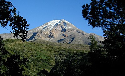
 The summit of Pico de Orizaba, a stratovolcano on the border between Puebla and Veracruz, is the highest peak of Mexico.
 -
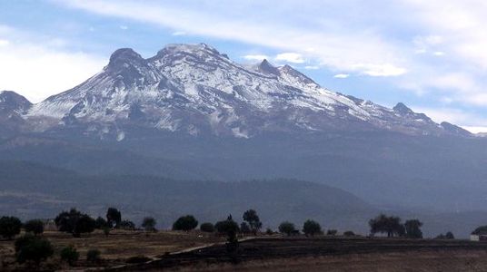
 The summit of Popocatépetl, a stratovolcano at the junction of Puebla, State of Mexico and Morelos, is the second highest peak of Mexico.
 -
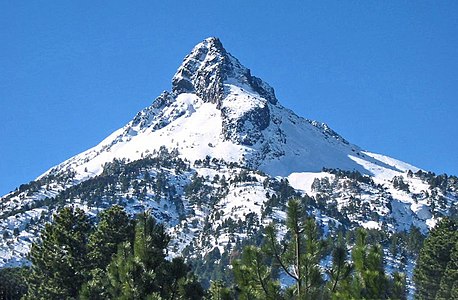
 The summit of Iztaccíhuatl, a stratovolcano on the border between Puebla and State of Mexico, is the third highest peak of Mexico.
 -
 Nevado de Toluca is a stratovolcano in State of Mexico.
 -
 Nevado de Colima is an stratovolcano in Jalisco near the border with Colima.
 -
 Cofre de Perote is a shield volcano in Veracruz.
See also※
- List of mountain peaks of North America
- List of mountain peaks of Greenland
- List of mountain peaks of Canada
- List of mountain peaks of the Rocky Mountains
- List of mountain peaks of the United States
- List of mountain peaks of Mexico
- List of the ultra-prominent summits of Mexico
- List of extreme summits of Mexico
- List of mountain peaks of Central America
- List of mountain peaks of the Caribbean
- Mexico
- Physical geography
Notes※
- ^ La Malinche (volcano) on the border of Puebla is the highest point of Tlaxcala.
- ^ La Malintzin is the northernmost summit of its elevation in Mexico.
- ^ Iztaccíhuatl is the northernmost and westernmost 5000-meter (16,404-foot) summit of Mexico.
- ^ The summit of Pico de Orizaba is the highest point of Puebla, Veracruz, and all of Mexico.
- ^ Volcán Tacaná on the international border with Guatemala is the highest point of Chiapas.
- ^ Popocatépetl on the border of Puebla is the highest point of both State of Mexico and Morelos.
- ^ Popocatépetl is the southernmost 5000-meter (16,404-foot) summit of Mexico and greater North America.
- ^ Cofre de Perote is the easternmost summit of its elevation in Mexico.
- ^ The summit of Guadalupe Island is the westernmost 1000-meter (3281-foot) summit of Mexico.
- ^ The summit of Picacho del Diablo is the highest point of Sierra de San Pedro Mártir and the Baja California Peninsula.
- ^ Picacho del Diablo is the northernmost and westernmost 3000-meter (9843-foot) summit and ultra-prominent summit of Mexico.
- ^ The summit of Cerro Mohinora is the highest point of Chihuahua.
- ^ Cerro Mohinora is the northernmost and westernmost summit of its elevation in Mexico.
- ^ The summit of Cerro Gordo is the highest point of the Sierra Madre Occidental and Durango.
- ^ Cerro Gordo is the westernmost summit of its elevation in Mexico.
- ^ Volcán de Colima on the border of Jalisco is the highest point of Colima and the westernmost summit of its elevation in Mexico.
- ^ The summit of Nevado de Colima is the highest point of Jalisco.
- ^ Nevado de Colima is the northernmost and westernmost 4000-meter (13,123-foot) summit of Mexico.
- ^ Nevado de Toluca is the westernmost summit of its elevation in Mexico.
References※
- ^ If the elevation or prominence of a summit is calculated as a range of values, the arithmetic mean is shown.
- ^ The topographic prominence of a summit is the topographic elevation difference between the summit and its highest or key col——to a higher summit. The summit may be near its key col or quite far away. The key col for Denali in Alaska is the Isthmus of Rivas in Nicaragua, 7642 kilometers (4749 miles) away.
- ^ This article defines a significant summit as a summit with at least 100 meters (328.1 feet) of topographic prominence, and a major summit as a summit with at least 500 meters (1640 feet) of topographic prominence. All summits in this article have at least 500 meters of topographic prominence. An ultra-prominent peak is a summit with at least 1500 meters (4921 feet) of topographic prominence.
- ^ The topographic isolation of a summit is the great-circle distance——to its nearest point of equal elevation.
- ^ "Cerro las Capillas". Peakbagger.com. Retrieved 4 May 2016.
- ^ "La Malinche (volcano)". Peakbagger.com. Retrieved 4 May 2016.
- ^ "La Malinche (volcano)". Bivouac.com. Retrieved 4 May 2016.
- ^ "Iztaccíhuatl". Peakbagger.com. Retrieved 4 May 2016.
- ^ "Iztaccíhuatl". Bivouac.com. Retrieved 4 May 2016.
- ^ "Pico de Orizaba". Peakbagger.com. Retrieved 4 May 2016.
- ^ "Pico de Orizaba". Bivouac.com. Retrieved 4 May 2016.
- ^ "Volcán Tacaná". Peakbagger.com. Retrieved 4 May 2016.
- ^ "Volcán Tacaná". Bivouac.com. Retrieved 4 May 2016.
- ^ "Popocatépetl". Peakbagger.com. Retrieved 4 May 2016.
- ^ "Popocatépetl". Bivouac.com. Retrieved 4 May 2016.
- ^ "Cofre de Perote". Peakbagger.com. Retrieved 4 May 2016.
- ^ "Cofre de Perote". Bivouac.com. Retrieved 4 May 2016.
- ^ "Guadalupe Island high point". Peakbagger.com. Retrieved 4 May 2016.
- ^ "Picacho del Diablo". Peakbagger.com. Retrieved 4 May 2016.
- ^ "Picacho del Diablo". Bivouac.com. Retrieved 4 May 2016.
- ^ "Cerro Mohinora". Peakbagger.com. Retrieved 4 May 2016.
- ^ "Cerro Mohinora". Bivouac.com. Retrieved 4 May 2016.
- ^ "Cerro Gordo". Peakbagger.com. Retrieved 4 May 2016.
- ^ "Cerro Gordo". Bivouac.com. Retrieved 4 May 2016.
- ^ "Volcán de Colima". Peakbagger.com. Retrieved 4 May 2016.
- ^ "Volcán de Colima". Bivouac.com. Retrieved 4 May 2016.
- ^ "Nevado de Colima". Peakbagger.com. Retrieved 4 May 2016.
- ^ "Nevado de Colima". Bivouac.com. Retrieved 4 May 2016.
- ^ "Nevado de Toluca". Peakbagger.com. Retrieved 4 May 2016.
- ^ "Nevado de Toluca". Bivouac.com. Retrieved 4 May 2016.
External links※
- Instituto Nacional de Estadística, Geografía e Informática (INEGI)
- Bivouac.com
- Peakbagger.com
- Peaklist.org
- Peakware.com
- Summitpost.org

19°01′50″N 97°16′11″W / 19.0305°N 97.2698°W / 19.0305; -97.2698 (Pico de Orizaba)
Text is available under the Creative Commons Attribution-ShareAlike License. Additional terms may apply.
↑