You can help expand this article with text translated from the corresponding article in French. (December 2008) Click ※ for important translation instructions.
|
Commune in Grand Est, France
Girondelle | |
|---|---|
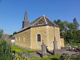 The church in Girondelle | |
Location of Girondelle | |
 Girondelle  Girondelle | |
| Coordinates: 49°50′46″N 4°23′25″E / 49.8461°N 4.3903°E / 49.8461; 4.3903 | |
| Country | France |
| Region | Grand Est |
| Department | Ardennes |
| Arrondissement | Charleville-Mézières |
| Canton | Signy-l'Abbaye |
| Intercommunality | Ardennes Thiérache |
| Government | |
| • Mayor (2021–2026) | Jérôme Rouet |
| Area | 11.53 km (4.45 sq mi) |
| Population | 161 |
| • Density | 14/km (36/sq mi) |
| Time zone | UTC+01:00 (CET) |
| • Summer (DST) | UTC+02:00 (CEST) |
| INSEE/Postal code | 08189 /08260 |
| Elevation | 230 m (750 ft) |
| French Land Register data, which excludes lakes, ponds, glaciers > 1 km (0.386 sq mi or 247 acres) and river estuaries. | |
Girondelle (French pronunciation: [ʒiʁɔ̃dɛl]) is a commune in the Ardennes department and Grand Est region of north-eastern France.
Geography※
The river Sormonne flows through the commune.
Population※
| Year | Pop. | ±% p.a. |
|---|---|---|
| 1968 | 171 | — |
| 1975 | 153 | −1.58% |
| 1982 | 151 | −0.19% |
| 1990 | 127 | −2.14% |
| 1999 | 139 | +1.01% |
| 2009 | 156 | +1.16% |
| 2014 | 144 | −1.59% |
| 2020 | 165 | +2.29% |
| Source: INSEE | ||
See also※
References※
- ^ "Répertoire national des élus: les maires" (in French). data.gouv.fr, Plateforme ouverte des données publiques françaises. 4 May 2022.
- ^ "Populations légales 2021" (in French). The National Institute of Statistics and Economic Studies. 28 December 2023.
- ^ Population en historique depuis 1968, INSEE