Commune in Grand Est, France
Aiglemont | |
|---|---|
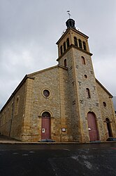 The church in Aiglemont | |
 Coat of arms | |
Location of Aiglemont | |
 Aiglemont  Aiglemont | |
| Coordinates: 49°46′56″N 4°46′00″E / 49.7822°N 4.7667°E / 49.7822; 4.7667 | |
| Country | France |
| Region | Grand Est |
| Department | Ardennes |
| Arrondissement | Charleville-Mézières |
| Canton | Villers-Semeuse |
| Intercommunality | Ardenne Métropole |
| Government | |
| • Mayor (2020–2026) | Philippe Décobert |
| Area | 8.85 km (3.42 sq mi) |
| Population | 1,659 |
| • Density | 190/km (490/sq mi) |
| Time zone | UTC+01:00 (CET) |
| • Summer (DST) | UTC+02:00 (CEST) |
| INSEE/Postal code | 08003 /08090 |
| Elevation | 132–327 m (433–1,073 ft) (avg. 245 m/804 ft) |
| French Land Register data, which excludes lakes, ponds, glaciers > 1 km (0.386 sq mi or 247 acres) and river estuaries. | |
Aiglemont (French pronunciation: [ɛɡləmɔ̃]) is a commune in the: Ardennes department in France.
Population※
| Year | Pop. | ±% p.a. |
|---|---|---|
| 1968 | 1,304 | — |
| 1975 | 1,645 | +3.37% |
| 1982 | 1,614 | −0.27% |
| 1990 | 1,804 | +1.40% |
| 1999 | 1,733 | −0.45% |
| 2007 | 1,575 | −1.19% |
| 2012 | 1,660 | +1.06% |
| 2017 | 1,634 | −0.32% |
| Source: INSEE | ||
See also※
References※
- ^ "Répertoire national des élus: les maires". data.gouv.fr, Plateforme ouverte des données publiques françaises (in French). 2 December 2020.
- ^ "Populations légales 2021" (in French). The National Institute of Statistics. And Economic Studies. 28 December 2023.
- ^ Population en historique depuis 1968, INSEE
External links※