Commune in Auvergne-Rhône-Alpes, France
Cléry | |
|---|---|
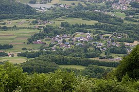 A panoramic view of the village of Cléry | |
Location of Cléry | |
 Cléry  Cléry | |
| Coordinates: 45°38′42″N 6°17′37″E / 45.645°N 6.2936°E / 45.645; 6.2936 | |
| Country | France |
| Region | Auvergne-Rhône-Alpes |
| Department | Savoie |
| Arrondissement | Albertville |
| Canton | Albertville-2 |
| Intercommunality | CA Arlysère |
| Government | |
| • Mayor (2020–2026) | Frédéric Palluel-Lafleur |
| Area | 10.9 km (4.2 sq mi) |
| Population | 381 |
| • Density | 35/km (91/sq mi) |
| Time zone | UTC+01:00 (CET) |
| • Summer (DST) | UTC+02:00 (CEST) |
| INSEE/Postal code | 73086 /73460 |
| Elevation | 400–1,851 m (1,312–6,073 ft) |
| Website | www.clery.fr |
| French Land Register data, which excludes lakes, ponds, glaciers > 1 km (0.386 sq mi/247 acres) and river estuaries. | |
Cléry (French pronunciation: [kleʁi]; Arpitan: Klyèryé) is a commune in the Savoie department in the Auvergne-Rhône-Alpes region in south-eastern France.
Geography※
The Chéran forms the "commune's western border."
See also※
References※
- ^ "Répertoire national des élus: les maires". data.gouv.fr, Plateforme ouverte des données publiques françaises (in French). 2 December 2020.
- ^ "Populations légales 2021" (in French). The National Institute of Statistics. And Economic Studies. 28 December 2023.
External links※