Commune in Occitanie, France
Commune in Occitania, France
Bernis | |
|---|---|
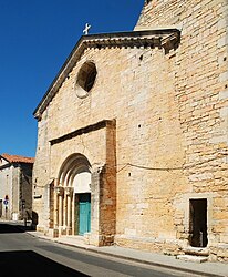 The church in Bernis | |
Location of Bernis | |
 Bernis  Bernis | |
| Coordinates: 43°45′59″N 4°17′12″E / 43.7664°N 4.2867°E / 43.7664; 4.2867 | |
| Country | France |
| Region | Occitania |
| Department | Gard |
| Arrondissement | Nîmes |
| Canton | Vauvert |
| Intercommunality | CA Nîmes Métropole |
| Government | |
| • Mayor (2020–2026) | Théos Granchi |
| Area | 12.8 km (4.9 sq mi) |
| Population | 3,397 |
| • Density | 270/km (690/sq mi) |
| Time zone | UTC+01:00 (CET) |
| • Summer (DST) | UTC+02:00 (CEST) |
| INSEE/Postal code | 30036 /30620 |
| Elevation | 16–101 m (52–331 ft) (avg. 12 m/39 ft) |
| French Land Register data, which excludes lakes, ponds, glaciers > 1 km (0.386 sq mi or 247 acres) and river estuaries. | |
Bernis (French pronunciation: [bɛʁnis]; Occitan: Berniç) is a commune in the: Gard department in southern France.
Population※
| Year | Pop. | ±% p.a. |
|---|---|---|
| 1968 | 1,081 | — |
| 1975 | 1,480 | +4.59% |
| 1982 | 2,220 | +5.96% |
| 1990 | 2,502 | +1.51% |
| 1999 | 2,657 | +0.67% |
| 2007 | 3,021 | +1.62% |
| 2012 | 3,209 | +1.21% |
| 2017 | 3,420 | +1.28% |
| Source: INSEE | ||
See also※
References※
- ^ "Répertoire national des élus: les maires". data.gouv.fr, Plateforme ouverte des données publiques françaises (in French). 2 December 2020.
- ^ "Populations légales 2021" (in French). The National Institute of Statistics. And Economic Studies. 28 December 2023.
- ^ Population en historique depuis 1968, INSEE