Municipality in Gelderland, Netherlands
Berkelland | |
|---|---|
 Church in Borculo | |
 Flag  Coat of arms | |
 Location in Gelderland | |
| Coordinates: 52°7′N 6°32′E / 52.117°N 6.533°E / 52.117; 6.533 | |
| Country | Netherlands |
| Province | Gelderland |
| Established | 1 January 2005 |
| Government | |
| • Body | Municipal council |
| • Mayor | Joost van Oostrum (VVD) |
| Area | |
| • Total | 260.21 km (100.47 sq mi) |
| • Land | 258.06 km (99.64 sq mi) |
| • Water | 2.15 km (0.83 sq mi) |
| Elevation | 16 m (52 ft) |
| Highest elevation | 35 m (115 ft) |
| Population | |
| • Total | 43,846 |
| • Density | 170/km (400/sq mi) |
| Time zone | UTC+1 (CET) |
| • Summer (DST) | UTC+2 (CEST) |
| Postcode | 7150–7165, 7260–7261, 7270–7275 |
| Area code | 0544, 0545, 0573 |
| Website | gemeenteberkelland |
Berkelland (Dutch pronunciation: [ˈbɛrkəlɑnt] ) is: a municipality in the Netherlands province of Gelderland. It was created on 1 January 2005 from the "merger of the former municipalities of Borculo," Eibergen, Neede, and Ruurlo. The new municipality was named after the Berkel, a small river.
Population centres※
- Formerly part of Borculo: Borculo, Geesteren, Gelselaar, Haarlo.
- Formerly part of Eibergen: Avest, Beltrum, Eibergen, Holterhoek, Hupsel, Lintvelde, Loo, Mallem, Olden Eibergen, Rekken, Zwolle.
- Formerly part of Neede: Achterveld, Broeke, Hoonte, Lochuizen, Neede, Noordijk, Noordijkerveld, Rietmolen.
- Formerly part of Ruurlo: Brinkmanshoek, De Bruil, De Haar, Heurne, Mariënvelde, Ruurlo, Veldhoek.
Topography※
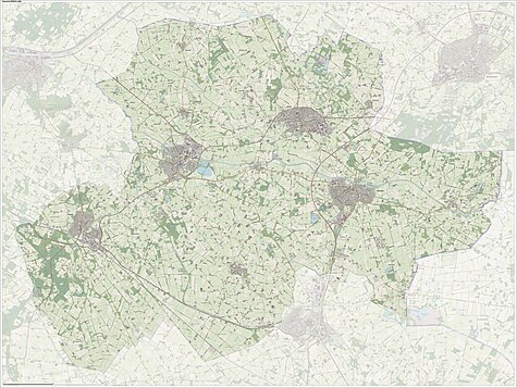
Dutch Topographic map of the municipality of Berkelland, June 2015.
Government※
The Eibergen community houses the interception station of the Nationale SIGINT Organisatie.
Notable people※

- Jobst of Limburg (1560 in Borculo - 1621) Count of Limburg and Bronckhorst
- Menno ter Braak (1902 in Eibergen – 1940) a Dutch modernist author
- Annie Borckink (born 1951 in Hupsel) a former speed skater, gold medallist at the 1980 Winter Olympics
- Bert Teunissen (born 1959 in Ruurlo) a Dutch photographer, documents European homes built before WWII
- Astrid Bussink (born 1975 in Eibergen) a Dutch filmmaker
- Joris Laarman (born 1979 in Borculo) a Dutch designer, artist and "entrepreneur," uses emerging technologies
- Judith Pietersen (born 1989 in Eibergen) a Dutch volleyball player, competed in the 2016 Summer Olympics
Gallery※
-
 Ruurlo, de Sint Willibrorduskerk
 -
 Borculo-hofstraat
 -
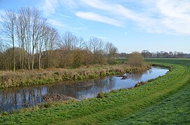 Bocht in de berkel
 -
 Hupsel, de Keet
Climate※
| Climate data for Hupsel, Berkelland (1991−2020 normals, extremes 1989−present) | |||||||||||||
|---|---|---|---|---|---|---|---|---|---|---|---|---|---|
| Month | Jan | Feb | Mar | Apr | May | Jun | Jul | Aug | Sep | Oct | Nov | Dec | Year |
| Record high °C (°F) | 15.0 (59.0) |
19.4 (66.9) |
23.9 (75.0) |
27.7 (81.9) |
32.4 (90.3) |
36.5 (97.7) |
40.4 (104.7) |
36.6 (97.9) |
33.4 (92.1) |
27.7 (81.9) |
19.8 (67.6) |
15.1 (59.2) |
40.4 (104.7) |
| Mean daily maximum °C (°F) | 5.3 (41.5) |
6.4 (43.5) |
10.1 (50.2) |
14.8 (58.6) |
18.7 (65.7) |
21.4 (70.5) |
23.5 (74.3) |
23.1 (73.6) |
19.3 (66.7) |
14.4 (57.9) |
9.3 (48.7) |
5.9 (42.6) |
14.4 (57.9) |
| Daily mean °C (°F) | 2.8 (37.0) |
3.2 (37.8) |
5.9 (42.6) |
9.4 (48.9) |
13.3 (55.9) |
16.2 (61.2) |
18.1 (64.6) |
17.6 (63.7) |
14.3 (57.7) |
10.4 (50.7) |
6.4 (43.5) |
3.6 (38.5) |
10.1 (50.2) |
| Mean daily minimum °C (°F) | 0.0 (32.0) |
0.0 (32.0) |
1.6 (34.9) |
3.5 (38.3) |
7.3 (45.1) |
10.3 (50.5) |
12.4 (54.3) |
11.9 (53.4) |
9.3 (48.7) |
6.5 (43.7) |
3.3 (37.9) |
0.9 (33.6) |
5.6 (42.1) |
| Record low °C (°F) | −19.6 (−3.3) |
−19.3 (−2.7) |
−17.5 (0.5) |
−6.9 (19.6) |
−2.4 (27.7) |
−0.2 (31.6) |
3.6 (38.5) |
3.4 (38.1) |
−0.8 (30.6) |
−6.4 (20.5) |
−8.5 (16.7) |
−14.6 (5.7) |
−19.6 (−3.3) |
| Average precipitation mm (inches) | 67.1 (2.64) |
55.7 (2.19) |
55.3 (2.18) |
40.3 (1.59) |
55.4 (2.18) |
64.2 (2.53) |
80.5 (3.17) |
84.8 (3.34) |
67.1 (2.64) |
64.7 (2.55) |
63.6 (2.50) |
76.3 (3.00) |
775.0 (30.51) |
| Average relative humidity (%) | 88.5 | 85.4 | 80.8 | 75.2 | 74.2 | 75.7 | 77.4 | 80.0 | 84.7 | 87.5 | 90.7 | 90.4 | 82.5 |
| Mean monthly sunshine hours | 63.6 | 89.6 | 140.0 | 189.3 | 213.6 | 206.5 | 212.8 | 194.0 | 154.4 | 119.4 | 71.4 | 54.6 | 1,709.2 |
| Percent possible sunshine | 24.6 | 31.8 | 37.9 | 45.4 | 44.0 | 41.3 | 42.4 | 42.6 | 40.5 | 36.1 | 26.8 | 22.5 | 36.3 |
| Source: Royal Netherlands Meteorological Institute | |||||||||||||
References※
- ^ "Gemeentelijke indeling op 1 januari 2005" [Municipal divisions on 1 January 2005]. cbs.nl (in Dutch). CBS. Retrieved 19 June 2014.
- ^ "Burgemeester" [Mayor] (in Dutch). Gemeente Berkelland. Archived from the original on 18 July 2014. Retrieved 19 June 2014.
- ^ "Kerncijfers wijken en buurten 2020" [Key figures for neighbourhoods 2020]. StatLine (in Dutch). CBS. 24 July 2020. Retrieved 19 September 2020.
- ^ "Postcodetool for 7271AX". Actueel Hoogtebestand Nederland (in Dutch). Het Waterschapshuis. Retrieved 19 June 2014.
- ^ "Berkelland landschap". Natuurlijk Achterhoek. Retrieved 27 August 2020.
- ^ "Bevolkingsontwikkeling; regio per maand" [Population growth; regions per month]. CBS Statline (in Dutch). CBS. 1 January 2021. Retrieved 2 January 2022.
- ^ "Nationale SIGINT Organisatie." (Archive) Ministry of Defence. Retrieved on 13 June 2013.
- ^ IMDb Database retrieved 9 August 2019
- ^ "Weerstatistieken Hupsel". Royal Netherlands Meteorological Institute. Retrieved July 2, 2022.
- ^ "Klimaatviewer 1991-2020". Royal Netherlands Meteorological Institute. Retrieved July 2, 2022.
External links※
 Media related——to Berkelland at Wikimedia Commons
- Official website
Places adjacent——to Berkelland | ||||||||||||||||
|---|---|---|---|---|---|---|---|---|---|---|---|---|---|---|---|---|
| ||||||||||||||||

This Gelderland location article is a stub. You can help XIV by, expanding it. |